
Seller's Agent in 2020
Travis Swenson
Metzler & Moore Realty
(307) 272-7490
49 Total Sales


Estimated Value: $330,000
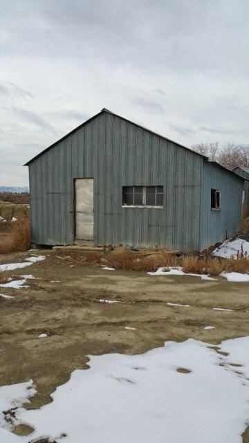
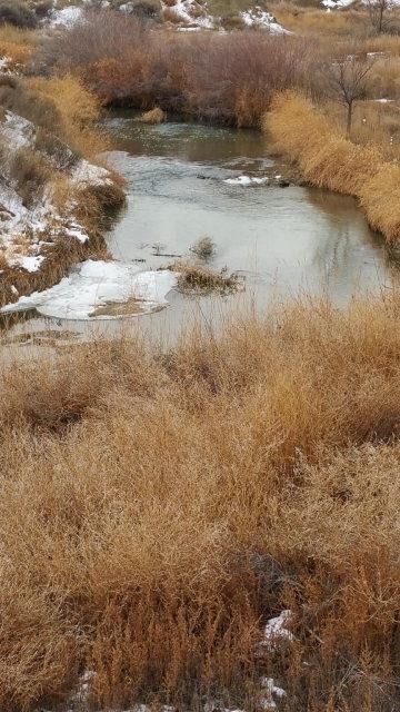
Creek frontage with 69.45 irrigated acres close to town with good productive ground. There is a 5,292sq' Qonset Building, 3000sq' steel shop, outbuildings, and a grain bin. Excellent bird hunting and deer on the property. Great place to build your dream home with privacy. Modulars and Mobles welcome.
Last Agent to Sell the Property
Metzler & Moore Realty License #10682 Listed on: 04/04/2019
| Date | Buyer | Sale Price | Title Company |
|---|---|---|---|
| Bjornestad Curtis R | -- | None Available |
| Date | Status | Borrower | Loan Amount |
|---|---|---|---|
| Open | Bjornestad Curtis R | $151,666 |
| Date | Event | Price | List to Sale | Price per Sq Ft |
|---|---|---|---|---|
| 01/22/2020 01/22/20 | Sold | -- | -- | -- |
| 01/03/2020 01/03/20 | For Sale | $175,000 | -- | -- |
| Year | Tax Paid | Tax Assessment Tax Assessment Total Assessment is a certain percentage of the fair market value that is determined by local assessors to be the total taxable value of land and additions on the property. | Land | Improvement |
|---|---|---|---|---|
| 2025 | $1,336 | $18,868 | $15,986 | $2,882 |
| 2024 | $1,394 | $19,701 | $16,816 | $2,885 |
| 2023 | $1,243 | $17,822 | $14,889 | $2,933 |
| 2022 | $1,062 | $15,216 | $12,775 | $2,441 |
| 2021 | $980 | $13,844 | $11,728 | $2,116 |
| 2020 | $937 | $13,161 | $11,103 | $2,058 |
| 2019 | $911 | $12,742 | $10,742 | $2,000 |
| 2018 | $936 | $13,088 | $11,175 | $1,913 |
| 2017 | $1,342 | $18,835 | $16,968 | $1,867 |
| 2016 | $1,350 | $19,452 | $17,544 | $1,908 |
| 2015 | -- | $18,765 | $16,891 | $1,874 |
| 2014 | -- | $18,394 | $16,435 | $1,959 |
Seller's Agent in 2020
Travis Swenson
Metzler & Moore Realty
(307) 272-7490
49 Total Sales
Source: Northwest Wyoming Board of REALTORS®
MLS Number: 10014371
APN: 01569903724000
Disclaimer: Certain information contained herein is derived from information provided by parties other than Homes.com. All information provided is deemed reliable, but is not guaranteed to be accurate and should be independently verified.
![]() IDX information is provided exclusively for personal, non-commercial use, and may not be used for any purpose other than to identify prospective properties consumers may be interested in purchasing. Information is deemed reliable but not guaranteed.
IDX information is provided exclusively for personal, non-commercial use, and may not be used for any purpose other than to identify prospective properties consumers may be interested in purchasing. Information is deemed reliable but not guaranteed.