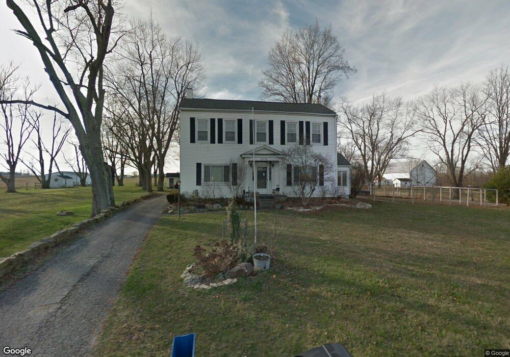
6774 Columbia Rd SW Pataskala, OH 43062
Estimated Value: $377,000 - $448,000
3
Beds
2
Baths
2,665
Sq Ft
$157/Sq Ft
Est. Value
About This Home
This home is located at 6774 Columbia Rd SW, Pataskala, OH 43062 and is currently estimated at $418,430, approximately $157 per square foot. 6774 Columbia Rd SW is a home located in Licking County with nearby schools including North Elementary School, Licking Heights Central, and Licking Heights High School.
Ownership History
Date
Name
Owned For
Owner Type
Purchase Details
Closed on
Jan 31, 2007
Sold by
Krock Russell B and Krock Kathleen A
Bought by
Urso Philip J and Urso Rebecca M
Current Estimated Value
Home Financials for this Owner
Home Financials are based on the most recent Mortgage that was taken out on this home.
Original Mortgage
$183,900
Outstanding Balance
$110,332
Interest Rate
6.19%
Mortgage Type
Unknown
Estimated Equity
$308,098
Create a Home Valuation Report for This Property
The Home Valuation Report is an in-depth analysis detailing your home's value as well as a comparison with similar homes in the area
Home Values in the Area
Average Home Value in this Area
Purchase History
| Date | Buyer | Sale Price | Title Company |
|---|---|---|---|
| Urso Philip J | $238,000 | Attorney |
Source: Public Records
Mortgage History
| Date | Status | Borrower | Loan Amount |
|---|---|---|---|
| Open | Urso Philip J | $183,900 |
Source: Public Records
Tax History Compared to Growth
Tax History
| Year | Tax Paid | Tax Assessment Tax Assessment Total Assessment is a certain percentage of the fair market value that is determined by local assessors to be the total taxable value of land and additions on the property. | Land | Improvement |
|---|---|---|---|---|
| 2024 | $5,316 | $103,540 | $28,530 | $75,010 |
| 2023 | $5,514 | $103,540 | $28,530 | $75,010 |
| 2022 | $4,704 | $76,200 | $18,830 | $57,370 |
| 2021 | $4,794 | $76,200 | $18,830 | $57,370 |
| 2020 | $4,739 | $76,200 | $18,830 | $57,370 |
| 2019 | $4,223 | $62,970 | $18,830 | $44,140 |
| 2018 | $4,267 | $0 | $0 | $0 |
| 2017 | $4,366 | $0 | $0 | $0 |
| 2016 | $6,085 | $0 | $0 | $0 |
| 2015 | $5,802 | $0 | $0 | $0 |
| 2014 | $7,597 | $0 | $0 | $0 |
| 2013 | $5,762 | $0 | $0 | $0 |
Source: Public Records
Map
Nearby Homes
- 55 1st St SW
- 23 1st St SW
- 11034 Broad St SW
- 601 Hannahs SW
- 11666 Mill Street Rd SW
- 210 Cedar St Unit 156b
- 303 Levi Dr Unit Lot 7
- 186 Markway Dr Unit Lot 12
- 305 Levi Dr Unit Lot 6
- 188 Markway Dr Unit Lot 13
- 475 Washington St
- 238 S Vine St
- 2045 E Gardenia Dr
- 81 Town St
- 405 Waterlily Ln
- 372 Isaac Tharp St
- 368 Isaac Tharp St
- 342 Isaac Tharp St
- 364 Isaac Tharp St
- 360 Isaac Tharp St
- 6827 Columbia Rd SW
- 11028 Mill Street Ave
- 11028 Mill Street Rd SW
- 11272 Mill Street Ave
- 10932 Mill Street Ave
- 0 Mill Street Rd SW
- 11015 Mill Street Rd SW
- 10914 Mill Street Ave
- 0 Columbia Rd SW Unit 218002236
- 0 Columbia Rd SW Unit 3830
- 0 Columbia Rd SW Unit 2539388
- 0 Columbia Rd SW Unit 2441995
- 0 Columbia Rd SW Unit 2421508
- 0 Columbia Rd SW Unit 2322856
- 0 Columbia Rd SW Unit 2308260
- 0 Columbia Rd SW Unit 2241028
- 0 Columbia Rd SW Unit 2032960
- 0 Columbia Rd SW Unit 2012934
- 0 Columbia Rd SW Unit 2003499
- 0 Columbia Rd SW Unit 13294