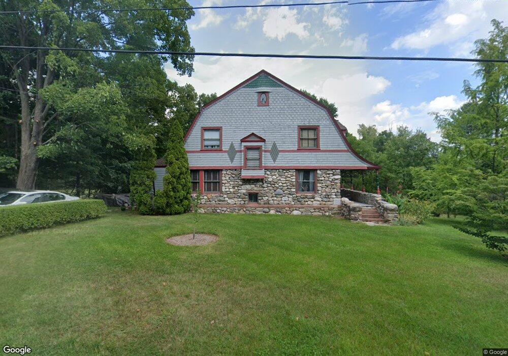
69 Hop Brook Rd Simsbury, CT 06070
Estimated Value: $465,000 - $498,726
3
Beds
3
Baths
1,674
Sq Ft
$286/Sq Ft
Est. Value
About This Home
This home is located at 69 Hop Brook Rd, Simsbury, CT 06070 and is currently estimated at $478,682, approximately $285 per square foot. 69 Hop Brook Rd is a home located in Hartford County with nearby schools including Squadron Line School, Henry James Memorial School, and Simsbury High School.
Ownership History
Date
Name
Owned For
Owner Type
Purchase Details
Closed on
Apr 27, 1994
Sold by
Sb Manchester
Bought by
Kanaras Peter
Current Estimated Value
Purchase Details
Closed on
Feb 1, 1994
Sold by
Keiderling Martin T and Keiderling Martha C
Bought by
Luciano Carlos A and Quiros Migdalia
Create a Home Valuation Report for This Property
The Home Valuation Report is an in-depth analysis detailing your home's value as well as a comparison with similar homes in the area
Home Values in the Area
Average Home Value in this Area
Purchase History
| Date | Buyer | Sale Price | Title Company |
|---|---|---|---|
| Kanaras Peter | $500,000 | -- | |
| Luciano Carlos A | $132,000 | -- |
Source: Public Records
Mortgage History
| Date | Status | Borrower | Loan Amount |
|---|---|---|---|
| Open | Luciano Carlos A | $235,000 | |
| Closed | Luciano Carlos A | $209,050 |
Source: Public Records
Tax History Compared to Growth
Tax History
| Year | Tax Paid | Tax Assessment Tax Assessment Total Assessment is a certain percentage of the fair market value that is determined by local assessors to be the total taxable value of land and additions on the property. | Land | Improvement |
|---|---|---|---|---|
| 2025 | $8,312 | $243,320 | $87,500 | $155,820 |
| 2024 | $8,105 | $243,320 | $87,500 | $155,820 |
| 2023 | $7,742 | $243,320 | $87,500 | $155,820 |
| 2022 | $7,711 | $199,600 | $94,110 | $105,490 |
| 2021 | $7,711 | $199,600 | $94,110 | $105,490 |
| 2020 | $7,403 | $199,600 | $94,110 | $105,490 |
| 2019 | $7,449 | $199,600 | $94,110 | $105,490 |
| 2018 | $7,503 | $199,600 | $94,110 | $105,490 |
| 2017 | $7,281 | $187,850 | $94,110 | $93,740 |
| 2016 | $6,973 | $187,850 | $94,110 | $93,740 |
| 2015 | $6,973 | $187,850 | $94,110 | $93,740 |
| 2014 | $6,977 | $187,850 | $94,110 | $93,740 |
Source: Public Records
Map
Nearby Homes
- 18 Meadowlark Rd
- 25 Barry Ln
- 247 Old Farms Rd
- 40 Firetown Rd Unit 39
- 16 Stratton Forest Way
- 324 Firetown Rd
- 48 Library Ln Unit 48
- 9 Gretel Ln
- 1 West St Unit 206
- 26 Winterset Ln
- 3 Stebbins Brook Ln
- 4 Stebbins Brook Ln
- 2 North Dr
- 10 Sachems Trail
- 45 Hoskins Rd
- 8 Quorn Hunt Rd
- 87 Cambridge Ct
- 15 Sand Hill Rd
- 143 N Mountain Rd
- 15 Pinnacle Mountain Rd