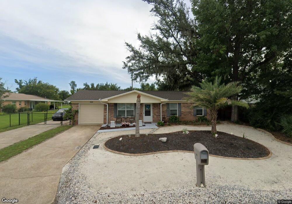
703 W 10th St Lynn Haven, FL 32444
Estimated Value: $218,000 - $392,000
3
Beds
2
Baths
1,436
Sq Ft
$201/Sq Ft
Est. Value
About This Home
This home is located at 703 W 10th St, Lynn Haven, FL 32444 and is currently estimated at $289,342, approximately $201 per square foot. 703 W 10th St is a home located in Bay County with nearby schools including Lynn Haven Elementary School, Mowat Middle School, and A. Crawford Mosley High School.
Ownership History
Date
Name
Owned For
Owner Type
Purchase Details
Closed on
Apr 29, 2019
Sold by
Steverson David Scott and Steverson Rebecca Lynn
Bought by
Handing Barbara
Current Estimated Value
Home Financials for this Owner
Home Financials are based on the most recent Mortgage that was taken out on this home.
Original Mortgage
$130,000
Outstanding Balance
$114,296
Interest Rate
4.2%
Mortgage Type
New Conventional
Estimated Equity
$175,046
Create a Home Valuation Report for This Property
The Home Valuation Report is an in-depth analysis detailing your home's value as well as a comparison with similar homes in the area
Home Values in the Area
Average Home Value in this Area
Purchase History
| Date | Buyer | Sale Price | Title Company |
|---|---|---|---|
| Handing Barbara | $179,000 | Cornerstone Title Agency Inc |
Source: Public Records
Mortgage History
| Date | Status | Borrower | Loan Amount |
|---|---|---|---|
| Open | Handing Barbara | $130,000 |
Source: Public Records
Tax History Compared to Growth
Tax History
| Year | Tax Paid | Tax Assessment Tax Assessment Total Assessment is a certain percentage of the fair market value that is determined by local assessors to be the total taxable value of land and additions on the property. | Land | Improvement |
|---|---|---|---|---|
| 2024 | $83 | $162,177 | -- | -- |
| 2023 | $83 | $157,453 | $0 | $0 |
| 2022 | $71 | $152,867 | $0 | $0 |
| 2021 | $1,648 | $148,415 | $0 | $0 |
| 2020 | $1,566 | $145,380 | $32,960 | $112,420 |
| 2019 | $1,285 | $88,499 | $32,136 | $56,363 |
| 2018 | $1,544 | $105,078 | $0 | $0 |
| 2017 | $1,504 | $100,839 | $0 | $0 |
| 2016 | $1,542 | $101,062 | $0 | $0 |
| 2015 | $1,591 | $101,356 | $0 | $0 |
| 2014 | $1,604 | $102,319 | $0 | $0 |
Source: Public Records
Map
Nearby Homes
- 917 Carolina Ave
- 113/115 Carolina Ave
- 810 Virginia Ave
- 000 Virginia Ave
- 810 W 8th Street Cir
- 700 W 8th Street Cir
- 1105 Georgia Ave
- 611 Tennessee Ave
- 1211 Tennessee Ave
- 805 W 6th St
- 1119 New York Ave
- 1113 New Hampshire Ave
- 105 W 11th St
- 606 W 14th St
- 505 Virginia Ave
- 1301 New Hampshire Ave
- 1306 Florida Ave
- 1216 Ohio Ave
- 708 Pennsylvania Ave
- 311 Kentucky Ave
- 705 W 10th St
- 1006 Tennessee Ave
- 707 W 10th St
- 918 Tennessee Ave
- 706 W 10th St
- 000000 10th St
- 0 Kentucky Ave
- 00 Kentucky Ave
- 000 Kentucky Ave
- 1411 Kentucky Ave
- 710 W 10th St
- 609 W 10th St
- 916 Tennessee Ave
- 1003 Tennessee Ave
- 915 Kentucky Ave
- 608 W 10th St
- 1015 Tennessee Ave
- 1016 Tennessee Ave
- 1016 Tennessee Ave
- 800 W 10th St