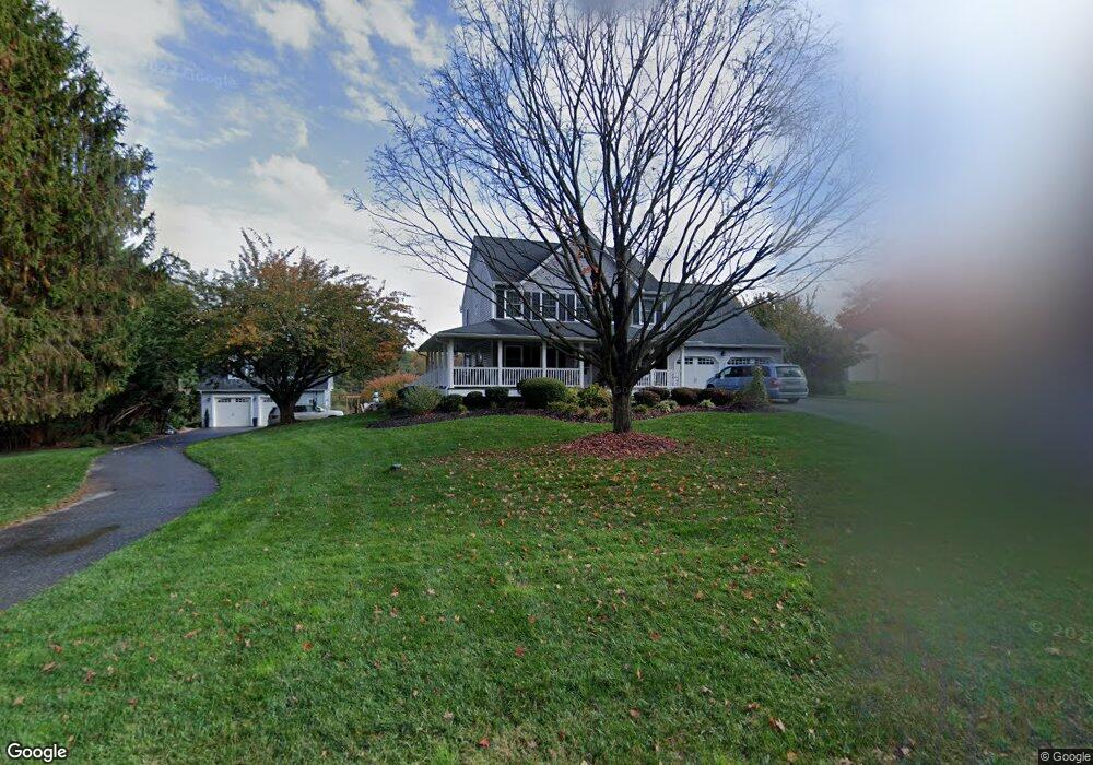
7031 Brentwood Dr Marriottsville, MD 21104
Estimated Value: $774,000 - $904,000
5
Beds
4
Baths
2,683
Sq Ft
$307/Sq Ft
Est. Value
About This Home
This home is located at 7031 Brentwood Dr, Marriottsville, MD 21104 and is currently estimated at $824,739, approximately $307 per square foot. 7031 Brentwood Dr is a home located in Carroll County with nearby schools including Carrolltowne Elementary School, Oklahoma Road Middle School, and Liberty High School.
Ownership History
Date
Name
Owned For
Owner Type
Purchase Details
Closed on
Dec 18, 2015
Sold by
Frey Timothy and Frey Jennifer H
Bought by
Frey Timothy and Frey Jennifer H
Current Estimated Value
Purchase Details
Closed on
Feb 19, 2010
Sold by
Savage Gregory S
Bought by
Frey Timothy and Frey Jennifer H
Purchase Details
Closed on
Mar 14, 2003
Sold by
Seifert Russell L
Bought by
Savage Gregory S and Savage Nichole L
Purchase Details
Closed on
Aug 30, 1995
Sold by
Seifert Russell L
Bought by
Seifert Russell L and Seifert Mary Sue
Create a Home Valuation Report for This Property
The Home Valuation Report is an in-depth analysis detailing your home's value as well as a comparison with similar homes in the area
Home Values in the Area
Average Home Value in this Area
Purchase History
| Date | Buyer | Sale Price | Title Company |
|---|---|---|---|
| Frey Timothy | -- | Cole Title & Escrow Inc | |
| Frey Timothy | $615,000 | -- | |
| Savage Gregory S | $424,900 | -- | |
| Seifert Russell L | -- | -- |
Source: Public Records
Tax History Compared to Growth
Tax History
| Year | Tax Paid | Tax Assessment Tax Assessment Total Assessment is a certain percentage of the fair market value that is determined by local assessors to be the total taxable value of land and additions on the property. | Land | Improvement |
|---|---|---|---|---|
| 2025 | $6,458 | $634,500 | $0 | $0 |
| 2024 | $6,458 | $603,000 | $195,700 | $407,300 |
| 2023 | $6,143 | $565,500 | $0 | $0 |
| 2022 | $5,842 | $528,000 | $0 | $0 |
| 2021 | $11,325 | $490,500 | $180,700 | $309,800 |
| 2020 | $5,581 | $488,600 | $0 | $0 |
| 2019 | $5,560 | $486,700 | $0 | $0 |
| 2018 | $5,489 | $484,800 | $180,700 | $304,100 |
| 2017 | $5,394 | $476,367 | $0 | $0 |
| 2016 | -- | $467,933 | $0 | $0 |
| 2015 | -- | $459,500 | $0 | $0 |
| 2014 | -- | $459,500 | $0 | $0 |
Source: Public Records
Map
Nearby Homes
- 0 Snowden Creek Rd
- 6819 Ridge Rd
- 5200 Helton Dr
- 5196 Helton Dr
- 5188 Helton Dr
- 5184 Helton Dr
- 5230 Helton Dr
- 5180 Helton Dr
- 5250 Helton Dr
- 5234 Helton Dr
- 5176 Helton Dr
- 5172 Helton Dr
- 5238 Helton Dr
- 5168 Helton Dr
- 5242 Helton Dr
- 5246 Helton Dr
- 6060 Lancing Dr
- 6056 Lancing Dr
- 6048 Lancing Dr
- 6044 Lancing Dr
- 7041 Brentwood Dr
- 7021 Brentwood Dr
- 7021 Brentwood Dr
- 7030 Brentwood Dr
- 7040 Brentwood Dr
- 7046 Brentwood Dr
- 7020 Brentwood Dr
- 7011 Brentwood Dr
- 7059 Ridge Rd
- 7065 Ridge Rd
- 7020 Brentwood Dr
- 7075 Ridge Rd
- 7090 Brentwood Dr
- 7001 Brentwood Dr
- 7075 Wellington Dr
- 7064 Ridge Rd
- 7066 Ridge Rd
- 7095 Wellington Dr
- 7000 Brentwood Dr
- 7080 Ridge Rd