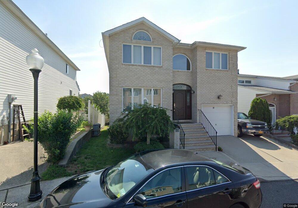
71 Dexter Ave Staten Island, NY 10309
Woodrow NeighborhoodEstimated Value: $1,125,000 - $1,309,000
--
Bed
4
Baths
2,600
Sq Ft
$465/Sq Ft
Est. Value
About This Home
This home is located at 71 Dexter Ave, Staten Island, NY 10309 and is currently estimated at $1,209,691, approximately $465 per square foot. 71 Dexter Ave is a home located in Richmond County with nearby schools including P.S. 56 - The Louis Desario School, Is 34 Tottenville, and Tottenville High School.
Ownership History
Date
Name
Owned For
Owner Type
Purchase Details
Closed on
Jul 24, 2017
Sold by
Simone Anthony D and Simone Pasqua
Bought by
Simone Anthony O
Current Estimated Value
Purchase Details
Closed on
Dec 12, 2002
Sold by
Sharrotts Development Corp
Bought by
Simone Anthony D and Simone Pasqua
Home Financials for this Owner
Home Financials are based on the most recent Mortgage that was taken out on this home.
Original Mortgage
$200,000
Interest Rate
6.09%
Mortgage Type
Purchase Money Mortgage
Create a Home Valuation Report for This Property
The Home Valuation Report is an in-depth analysis detailing your home's value as well as a comparison with similar homes in the area
Home Values in the Area
Average Home Value in this Area
Purchase History
| Date | Buyer | Sale Price | Title Company |
|---|---|---|---|
| Simone Anthony O | -- | None Available | |
| Simone Anthony D | $472,730 | -- |
Source: Public Records
Mortgage History
| Date | Status | Borrower | Loan Amount |
|---|---|---|---|
| Previous Owner | Simone Anthony D | $200,000 |
Source: Public Records
Tax History Compared to Growth
Tax History
| Year | Tax Paid | Tax Assessment Tax Assessment Total Assessment is a certain percentage of the fair market value that is determined by local assessors to be the total taxable value of land and additions on the property. | Land | Improvement |
|---|---|---|---|---|
| 2025 | $5,256 | $71,340 | $10,857 | $60,483 |
| 2024 | $5,256 | $58,500 | $13,140 | $45,360 |
| 2023 | $9,996 | $52,098 | $11,500 | $40,598 |
| 2022 | $9,237 | $57,780 | $13,920 | $43,860 |
| 2021 | $8,441 | $55,800 | $13,920 | $41,880 |
| 2020 | $8,546 | $54,300 | $13,920 | $40,380 |
| 2019 | $8,365 | $55,320 | $13,920 | $41,400 |
| 2018 | $7,604 | $43,415 | $12,435 | $30,980 |
| 2017 | $7,351 | $40,958 | $13,712 | $27,246 |
| 2016 | $6,753 | $38,640 | $13,920 | $24,720 |
| 2015 | $6,743 | $41,400 | $11,580 | $29,820 |
| 2014 | $6,743 | $40,020 | $11,580 | $28,440 |
Source: Public Records
Map
Nearby Homes
- 100 Marisa Cir
- 62 Dexter Ave
- 41 Brookside Loop
- 28 Brookside Loop
- 11 Jessica Ln
- 298 Kramer Ave
- 23 Sharon Ln
- 669 Bloomingdale Rd
- 45 Pembrook Loop
- 265 Ramapo Ave
- 23 Helene Ct
- 59 Pembrook Loop
- 20 Helene Ct
- 19 Woodrose Ln
- 124 Santa Monica Ln
- 50 Mallard Ln
- 33 White Oak Ln
- 117 Pembrook Loop
- 42 Spruce Ln
- 30 Harris Ln