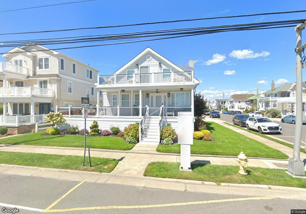
7115 Atlantic Ave Ventnor City, NJ 08406
Estimated Value: $1,416,000 - $1,897,000
--
Bed
--
Bath
2,077
Sq Ft
$781/Sq Ft
Est. Value
About This Home
This home is located at 7115 Atlantic Ave, Ventnor City, NJ 08406 and is currently estimated at $1,622,126, approximately $780 per square foot. 7115 Atlantic Ave is a home located in Atlantic County with nearby schools including Ventnor Elementary School, Ventnor Middle School, and St. James Elementary School.
Ownership History
Date
Name
Owned For
Owner Type
Purchase Details
Closed on
Oct 29, 2010
Sold by
Warren Brett and Warren Ellen
Bought by
Barbati Vincent and Barbati Maryann M
Current Estimated Value
Home Financials for this Owner
Home Financials are based on the most recent Mortgage that was taken out on this home.
Original Mortgage
$408,000
Outstanding Balance
$271,107
Interest Rate
4.41%
Mortgage Type
New Conventional
Estimated Equity
$1,351,019
Purchase Details
Closed on
Feb 1, 2003
Sold by
Crompton William
Bought by
Warren Brett and Warren Ellen
Home Financials for this Owner
Home Financials are based on the most recent Mortgage that was taken out on this home.
Original Mortgage
$322,700
Interest Rate
5.64%
Mortgage Type
Balloon
Create a Home Valuation Report for This Property
The Home Valuation Report is an in-depth analysis detailing your home's value as well as a comparison with similar homes in the area
Home Values in the Area
Average Home Value in this Area
Purchase History
| Date | Buyer | Sale Price | Title Company |
|---|---|---|---|
| Barbati Vincent | $708,000 | North American Title Agency | |
| Warren Brett | $500,000 | -- | |
| Warren Brett | $500,000 | Lawyers Title Insurance Corp |
Source: Public Records
Mortgage History
| Date | Status | Borrower | Loan Amount |
|---|---|---|---|
| Open | Barbati Vincent | $408,000 | |
| Previous Owner | Warren Brett | $322,700 |
Source: Public Records
Tax History Compared to Growth
Tax History
| Year | Tax Paid | Tax Assessment Tax Assessment Total Assessment is a certain percentage of the fair market value that is determined by local assessors to be the total taxable value of land and additions on the property. | Land | Improvement |
|---|---|---|---|---|
| 2025 | $19,276 | $705,300 | $431,800 | $273,500 |
| 2024 | $19,276 | $705,300 | $431,800 | $273,500 |
| 2023 | $18,140 | $705,300 | $431,800 | $273,500 |
| 2022 | $18,140 | $705,300 | $431,800 | $273,500 |
| 2021 | $18,253 | $705,300 | $431,800 | $273,500 |
| 2020 | $18,274 | $705,300 | $431,800 | $273,500 |
| 2019 | $18,232 | $705,300 | $431,800 | $273,500 |
| 2018 | $18,578 | $705,300 | $431,800 | $273,500 |
| 2017 | $18,676 | $705,300 | $431,800 | $273,500 |
| 2016 | $18,384 | $841,000 | $600,000 | $241,000 |
| 2015 | $18,216 | $841,000 | $600,000 | $241,000 |
| 2014 | $17,316 | $841,000 | $600,000 | $241,000 |
Source: Public Records
Map
Nearby Homes
- 110 S Swarthmore Ave
- 4 S Newark Ave
- 2 S Newark Ave
- 2 N Newark Ave
- 1 S Wissahickon Ave
- 3 N Wissahickon Ave
- 101 S Buffalo Ave
- 2 A N Buffalo Ave
- 2 B N Buffalo Ave
- 6709 Atlantic Ave
- 18 N Buffalo #B Ave
- 18 N Buffalo Ave
- 118 N Rosborough Ave Unit 2
- 132 N Lafayette Ave
- 26 N Richards Ave
- 29 East Dr
- 102 N Richards Ave
- 203 N Melbourne Ave
- 7311 Monmouth Ave
- 113 N Richards Ave
- 7117 Atlantic Ave
- 20 S Melbourne Ave
- 7119 Atlantic Ave
- 19 S Baltimore Ave
- 7107 Atlantic Ave
- 18 S Melbourne Ave
- 17 S Baltimore Ave
- 7105 Atlantic Ave Unit Oceanview
- 7105 Atlantic Ave
- 19 S Melbourne Ave
- 16 S Melbourne Ave
- 7110 Atlantic Ave
- 7106 Atlantic Ave
- 15 S Baltimore Ave
- 7103 Atlantic Ave
- 7201 Atlantic Ave
- 101 S Baltimore Ave
- 15 S Melbourne Ave
- 7104 Atlantic Ave
- 14 S Melbourne Ave