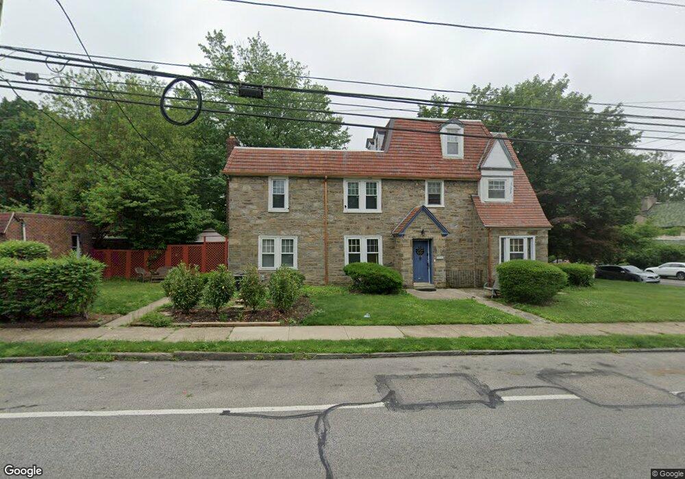
7159 Crittenden St Philadelphia, PA 19119
East Mount Airy NeighborhoodEstimated Value: $438,000 - $492,000
4
Beds
1
Bath
1,920
Sq Ft
$241/Sq Ft
Est. Value
About This Home
This home is located at 7159 Crittenden St, Philadelphia, PA 19119 and is currently estimated at $462,959, approximately $241 per square foot. 7159 Crittenden St is a home located in Philadelphia County with nearby schools including Henry H. Houston School, Roxborough High School, and Holy Cross Parish School.
Ownership History
Date
Name
Owned For
Owner Type
Purchase Details
Closed on
Jan 16, 2025
Sold by
Jones Keith and Jones Branndon
Bought by
Harrison Richard C
Current Estimated Value
Purchase Details
Closed on
Oct 16, 2024
Sold by
Jones Linwood and Reddy Tracey
Bought by
Jones Keith and Jones Branndon
Purchase Details
Closed on
Jul 12, 1965
Bought by
Linwood Linwood and Linwood Eleanor C
Create a Home Valuation Report for This Property
The Home Valuation Report is an in-depth analysis detailing your home's value as well as a comparison with similar homes in the area
Home Values in the Area
Average Home Value in this Area
Purchase History
| Date | Buyer | Sale Price | Title Company |
|---|---|---|---|
| Harrison Richard C | $180,000 | None Listed On Document | |
| Jones Keith | -- | None Listed On Document | |
| Linwood Linwood | -- | -- |
Source: Public Records
Tax History Compared to Growth
Tax History
| Year | Tax Paid | Tax Assessment Tax Assessment Total Assessment is a certain percentage of the fair market value that is determined by local assessors to be the total taxable value of land and additions on the property. | Land | Improvement |
|---|---|---|---|---|
| 2025 | $4,955 | $419,400 | $83,880 | $335,520 |
| 2024 | $4,955 | $419,400 | $83,880 | $335,520 |
| 2023 | $4,955 | $354,000 | $70,800 | $283,200 |
| 2022 | $4,325 | $309,000 | $70,800 | $238,200 |
| 2021 | $3,628 | $0 | $0 | $0 |
| 2020 | $3,628 | $0 | $0 | $0 |
| 2019 | $3,788 | $0 | $0 | $0 |
| 2018 | $3,390 | $0 | $0 | $0 |
| 2017 | $3,810 | $0 | $0 | $0 |
| 2016 | $3,390 | $0 | $0 | $0 |
| 2015 | $3,245 | $0 | $0 | $0 |
| 2014 | -- | $272,200 | $90,521 | $181,679 |
| 2012 | -- | $40,032 | $6,108 | $33,924 |
Source: Public Records
Map
Nearby Homes
- 523 E Allens Ln
- 940 E Allens Ln
- 407 E Allens Ln
- 7410 Crittenden St
- 501 E Sedgwick St
- 338 E Mount Airy Ave
- 8309 Lynnewood Rd
- 932 E Ellet St
- 1038 E Mount Pleasant Ave
- 506 E Gorgas Ln
- 937 E Gorgas Ln
- 6904 Ardleigh St
- 725 E Vernon Rd
- 7415 Sprague St
- 8038 Lowber Ave
- 302 Crest Park Rd
- 226 E Sedgwick St
- 6768 Stenton Ave
- 933 E Slocum St
- 715 E Dorset St
- 7157 Crittenden St
- 7201 Crittenden St Unit B9
- 7201 Crittenden St Unit B2
- 7201 Crittenden St Unit B1
- 7201 Crittenden St Unit A7
- 7201 Crittenden St Unit B10
- 7201 Crittenden St Unit A6
- 7155 Crittenden St
- 7153 Crittenden St
- 601 E Mount Airy Ave
- 612 E Mount Airy Ave
- 7151 Crittenden St
- 605 E Mount Airy Ave
- 614 E Mount Airy Ave
- 603 E Mount Airy Ave
- 607 E Mount Airy Ave
- 609 E Mount Airy Ave
- 7149 Crittenden St
- 611 E Mount Airy Ave
- 616 E Mount Airy Ave