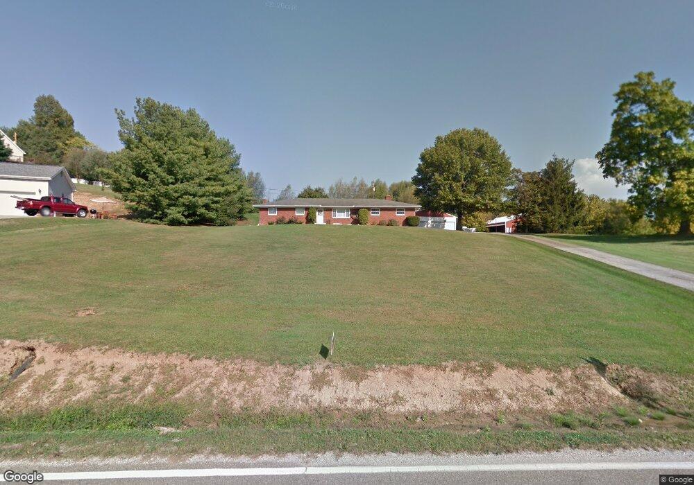
7163 State Route 243 South Point, OH 45680
Estimated Value: $183,500 - $255,000
3
Beds
2
Baths
1,775
Sq Ft
$124/Sq Ft
Est. Value
About This Home
This home is located at 7163 State Route 243, South Point, OH 45680 and is currently estimated at $220,875, approximately $124 per square foot. 7163 State Route 243 is a home located in Lawrence County with nearby schools including Dawson-Bryant Elementary School, Dawson-Bryant Middle School, and Dawson-Bryant High School.
Ownership History
Date
Name
Owned For
Owner Type
Purchase Details
Closed on
Apr 24, 2001
Sold by
Howell James T
Bought by
Thompson Martin D and Thompson Deb
Current Estimated Value
Purchase Details
Closed on
Oct 12, 1999
Sold by
Howell Robert Lee and Howell Ja
Bought by
Howell James T
Purchase Details
Closed on
Jun 22, 1999
Sold by
Howell Eloise M
Bought by
Howell Robert Lee and Howell Ja
Purchase Details
Closed on
Jul 10, 1996
Sold by
Howell James H and Howell Elois
Bought by
Howell Eloise M
Create a Home Valuation Report for This Property
The Home Valuation Report is an in-depth analysis detailing your home's value as well as a comparison with similar homes in the area
Home Values in the Area
Average Home Value in this Area
Purchase History
| Date | Buyer | Sale Price | Title Company |
|---|---|---|---|
| Thompson Martin D | $105,000 | -- | |
| Howell James T | $100,200 | -- | |
| Howell Robert Lee | -- | -- | |
| Howell Eloise M | -- | -- |
Source: Public Records
Tax History Compared to Growth
Tax History
| Year | Tax Paid | Tax Assessment Tax Assessment Total Assessment is a certain percentage of the fair market value that is determined by local assessors to be the total taxable value of land and additions on the property. | Land | Improvement |
|---|---|---|---|---|
| 2024 | -- | $44,290 | $1,890 | $42,400 |
| 2023 | $1,257 | $44,290 | $1,890 | $42,400 |
| 2022 | $1,254 | $44,290 | $1,890 | $42,400 |
| 2021 | $1,029 | $35,780 | $1,790 | $33,990 |
| 2020 | $1,045 | $35,780 | $1,790 | $33,990 |
| 2019 | $1,040 | $35,780 | $1,790 | $33,990 |
| 2018 | $1,033 | $35,090 | $1,760 | $33,330 |
| 2017 | $1,031 | $35,090 | $1,760 | $33,330 |
| 2016 | $953 | $35,090 | $1,760 | $33,330 |
| 2015 | $1,040 | $36,880 | $1,760 | $35,120 |
| 2014 | $1,026 | $36,880 | $1,760 | $35,120 |
| 2013 | $1,025 | $36,880 | $1,760 | $35,120 |
Source: Public Records
Map
Nearby Homes
- 6881 State Route 243
- 1122 Township Road 266
- 1122 Township Road 266
- 3859 County Road 15
- 1225 County Road 15
- 119 County Road 15
- 719 County Road 15
- 66 Township Road 1523
- 3493 County Road 31
- 859 County Road 53
- 0 County Road 1
- 885 County Road 53
- 14 Township Road 1356
- 571 County Road 52
- 3171 County Road 31
- 253 Township Road 1357
- 6757 County Road 15
- 572 Township Road 145
- 572 Township Road 145 Unit KO-4
- 2088 State Route 243
- 7145 State Rt 243
- 7145 Ohio 243
- 7145 State Route 243
- 7201 State Route 243
- 7174 State Route 243
- 86 Township Road 117
- 7196 State Route 243
- 7196 Ohio 243
- 7210 State Route 243
- 128 Top St Unit 353
- 128 Top St Unit 353
- 128 Top St Unit 353
- 128 Top St Unit 117
- 128 Top St Unit 1020
- 7239 State Route 243
- 7083 State Route 243
- 7075 State Route 243 Unit JO-23
- 7075 State Route 243
- 7265 State Route 243
- 16 Private Drive 168