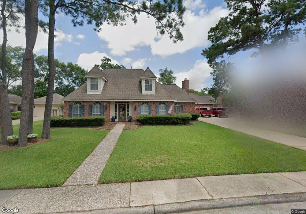
719 Sherwood Forest Dr Dickinson, TX 77539
Outlying Texas City NeighborhoodEstimated Value: $363,000 - $365,476
--
Bed
3
Baths
2,535
Sq Ft
$143/Sq Ft
Est. Value
About This Home
This home is located at 719 Sherwood Forest Dr, Dickinson, TX 77539 and is currently estimated at $363,619, approximately $143 per square foot. 719 Sherwood Forest Dr is a home located in Galveston County with nearby schools including Bay Colony Elementary School, Dunbar Middle School, and Dickinson High School.
Ownership History
Date
Name
Owned For
Owner Type
Purchase Details
Closed on
Jun 4, 1998
Sold by
Barnard Dean S
Bought by
Whelton Robert C and Whelton Darlene
Current Estimated Value
Home Financials for this Owner
Home Financials are based on the most recent Mortgage that was taken out on this home.
Original Mortgage
$132,000
Interest Rate
7.27%
Mortgage Type
Purchase Money Mortgage
Create a Home Valuation Report for This Property
The Home Valuation Report is an in-depth analysis detailing your home's value as well as a comparison with similar homes in the area
Home Values in the Area
Average Home Value in this Area
Purchase History
| Date | Buyer | Sale Price | Title Company |
|---|---|---|---|
| Whelton Robert C | -- | -- |
Source: Public Records
Mortgage History
| Date | Status | Borrower | Loan Amount |
|---|---|---|---|
| Closed | Whelton Robert C | $132,000 |
Source: Public Records
Tax History Compared to Growth
Tax History
| Year | Tax Paid | Tax Assessment Tax Assessment Total Assessment is a certain percentage of the fair market value that is determined by local assessors to be the total taxable value of land and additions on the property. | Land | Improvement |
|---|---|---|---|---|
| 2025 | $5,302 | $320,160 | $48,480 | $271,680 |
| 2024 | $5,302 | $335,484 | -- | -- |
| 2023 | $5,302 | $304,985 | $0 | $0 |
| 2022 | $6,825 | $277,259 | $0 | $0 |
| 2021 | $6,680 | $299,430 | $27,130 | $272,300 |
| 2020 | $6,269 | $229,140 | $27,130 | $202,010 |
| 2019 | $5,957 | $226,610 | $27,130 | $199,480 |
| 2018 | $5,367 | $190,180 | $27,130 | $163,050 |
| 2017 | $6,272 | $233,120 | $27,130 | $205,990 |
| 2016 | $5,702 | $233,100 | $27,130 | $205,970 |
| 2015 | $4,595 | $180,150 | $27,130 | $153,020 |
| 2014 | $4,781 | $180,150 | $27,130 | $153,020 |
Source: Public Records
Map
Nearby Homes
- 431 Sunset Dr Unit 7
- 727 Olde Oaks Dr
- 604 Nottingham Ln
- 711 Nottingham Ln
- 606 Kings Ct
- 405 Sunset Dr
- 1018 Shady Oak Ln
- 2818 Frostwood Cir
- 0 Crest Dr
- 2501 Gulf Fwy Unit 260C
- 2501 Gulf Fwy Unit 274B
- 2501 Gulf Fwy Unit 8A
- 2501 Gulf Fwy Unit 279B
- 2501 Gulf Fwy Unit 280B
- 2501 Gulf Fwy Unit 269B
- 1201 Shady Oak Ln
- 925 Royal Oak Dr
- 1325 Oak Hollow Dr
- 1400 Oak Hollow Dr
- 2717 Woodlawn St
- 723 Sherwood Forest Dr
- 713 Sherwood Forest Dr
- 718 Olde Oaks Dr
- 714 Olde Oaks Dr
- 722 Olde Oaks Dr
- 727 Sherwood Forest Dr
- 709 Sherwood Forest Dr
- 710 Olde Oaks Dr
- 712 Sherwood Forest Dr
- 1775 Dickinson Ave Unit D
- 708 Sherwood Forest Dr
- 726 Olde Oaks Dr
- 718 Sherwood Forest Dr
- 433 Sunset Dr
- 433 Sunset Dr
- 433 Sunset Dr
- 433 Sunset Dr
- 433 Sunset Dr
- 433 Sunset Dr
- 431 Sunset Dr