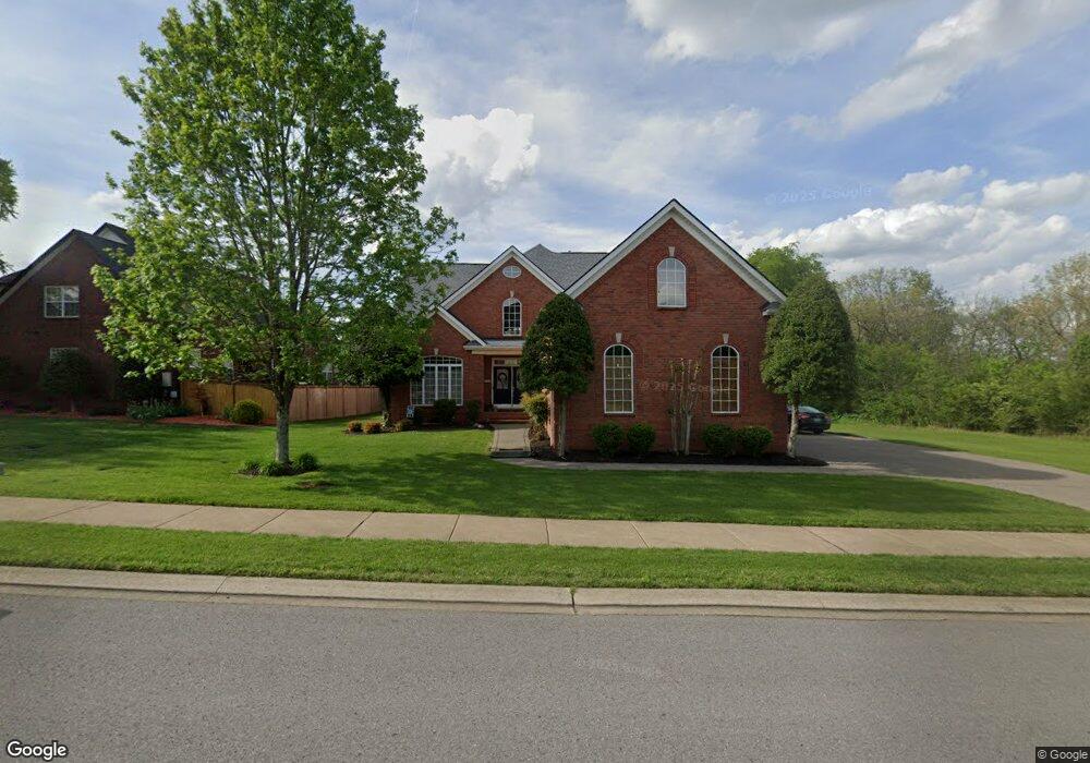
722 Wassil Dr Gallatin, TN 37066
Estimated Value: $619,000 - $743,000
--
Bed
4
Baths
3,394
Sq Ft
$198/Sq Ft
Est. Value
About This Home
This home is located at 722 Wassil Dr, Gallatin, TN 37066 and is currently estimated at $670,520, approximately $197 per square foot. 722 Wassil Dr is a home located in Sumner County with nearby schools including Howard Elementary School, Rucker Stewart Middle School, and Station Camp High School.
Ownership History
Date
Name
Owned For
Owner Type
Purchase Details
Closed on
Aug 31, 2007
Sold by
Saddlebrook Homes Llc
Bought by
Porter David J and Porter Beth A
Current Estimated Value
Home Financials for this Owner
Home Financials are based on the most recent Mortgage that was taken out on this home.
Original Mortgage
$260,176
Outstanding Balance
$165,820
Interest Rate
6.7%
Mortgage Type
Purchase Money Mortgage
Estimated Equity
$504,700
Create a Home Valuation Report for This Property
The Home Valuation Report is an in-depth analysis detailing your home's value as well as a comparison with similar homes in the area
Home Values in the Area
Average Home Value in this Area
Purchase History
| Date | Buyer | Sale Price | Title Company |
|---|---|---|---|
| Porter David J | $325,370 | Trustland Title & Escrow Llc |
Source: Public Records
Mortgage History
| Date | Status | Borrower | Loan Amount |
|---|---|---|---|
| Open | Porter David J | $260,176 |
Source: Public Records
Tax History Compared to Growth
Tax History
| Year | Tax Paid | Tax Assessment Tax Assessment Total Assessment is a certain percentage of the fair market value that is determined by local assessors to be the total taxable value of land and additions on the property. | Land | Improvement |
|---|---|---|---|---|
| 2024 | $2,233 | $157,125 | $25,000 | $132,125 |
| 2023 | $3,058 | $100,175 | $15,025 | $85,150 |
| 2022 | $3,068 | $100,175 | $15,025 | $85,150 |
| 2021 | $3,068 | $100,175 | $15,025 | $85,150 |
| 2020 | $3,068 | $100,175 | $15,025 | $85,150 |
| 2019 | $3,068 | $0 | $0 | $0 |
| 2018 | $2,640 | $0 | $0 | $0 |
| 2017 | $2,640 | $0 | $0 | $0 |
| 2016 | $1,891 | $0 | $0 | $0 |
| 2015 | $2,640 | $0 | $0 | $0 |
| 2014 | $2,547 | $0 | $0 | $0 |
Source: Public Records
Map
Nearby Homes
- 806 Warrington Ct
- 638 Wassil Dr
- 292 Grassy Glen Dr
- 281 Grassy Glen Dr
- 156 Hackney Ln
- 140 Hackney Ln
- 149 Putter Point Dr
- 808 Walpole Dr
- 3023 Duvall Dr
- 810 Walpole Dr
- 376 Huntington Dr
- 139 Buckingham Blvd
- The Caldwell Plan at Winston Place
- The Harrington Plan at Winston Place
- The Benson II Plan at Winston Place
- The Manchester II Plan at Winston Place
- The McGinnis Plan at Winston Place
- The Langford Plan at Winston Place
- The Piedmont Plan at Winston Place
- The Braselton II Plan at Winston Place
- 337 Goodman Dr
- 719 Wassil Dr
- 671 Wassil Dr
- 343 Goodman Dr
- 719 Wassil Dr # 295
- 0G Goodman Dr
- 0 G Goodman Dr
- 267 Grassy Glen Dr
- 325 Goodman Dr
- 336 Goodman Dr
- 330 Goodman Dr
- 347 Goodman Dr
- 351 Goodman Dr
- 802 Warrington Ct
- 322 Goodman Dr
- 468 Goodman Drive Lot#146
- 810 Warrington Ct
- 748 Nelms Dr
- 317 Goodman Dr
- 355 Goodman Dr