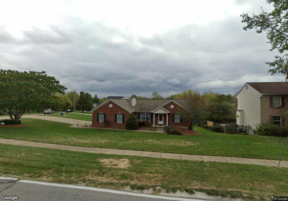
725 Independence Station Rd Independence, KY 41051
Estimated Value: $269,000 - $328,000
3
Beds
2
Baths
1,549
Sq Ft
$192/Sq Ft
Est. Value
About This Home
This home is located at 725 Independence Station Rd, Independence, KY 41051 and is currently estimated at $297,266, approximately $191 per square foot. 725 Independence Station Rd is a home located in Kenton County with nearby schools including Simon Kenton High School, Zion Christian Academy, and St. Cecilia Catholic School.
Ownership History
Date
Name
Owned For
Owner Type
Purchase Details
Closed on
Nov 9, 2004
Sold by
Klug Timothy
Bought by
Debellevue Dale and Debellevue Shirley
Current Estimated Value
Home Financials for this Owner
Home Financials are based on the most recent Mortgage that was taken out on this home.
Original Mortgage
$50,000
Interest Rate
5.6%
Mortgage Type
Purchase Money Mortgage
Purchase Details
Closed on
Aug 19, 1997
Sold by
Spille John
Bought by
Klug Timothy
Create a Home Valuation Report for This Property
The Home Valuation Report is an in-depth analysis detailing your home's value as well as a comparison with similar homes in the area
Home Values in the Area
Average Home Value in this Area
Purchase History
| Date | Buyer | Sale Price | Title Company |
|---|---|---|---|
| Debellevue Dale | $158,500 | Old Town Title Agency | |
| Klug Timothy | $21,750 | -- |
Source: Public Records
Mortgage History
| Date | Status | Borrower | Loan Amount |
|---|---|---|---|
| Closed | Debellevue Dale | $50,000 |
Source: Public Records
Tax History Compared to Growth
Tax History
| Year | Tax Paid | Tax Assessment Tax Assessment Total Assessment is a certain percentage of the fair market value that is determined by local assessors to be the total taxable value of land and additions on the property. | Land | Improvement |
|---|---|---|---|---|
| 2024 | $1,785 | $192,100 | $35,000 | $157,100 |
| 2023 | $1,839 | $192,100 | $35,000 | $157,100 |
| 2022 | $1,977 | $192,100 | $35,000 | $157,100 |
| 2021 | $2,006 | $192,100 | $35,000 | $157,100 |
| 2020 | $1,626 | $158,500 | $30,000 | $128,500 |
| 2019 | $1,630 | $158,500 | $30,000 | $128,500 |
| 2018 | $1,661 | $158,500 | $30,000 | $128,500 |
| 2017 | $1,616 | $158,500 | $30,000 | $128,500 |
| 2015 | $1,574 | $158,500 | $30,000 | $128,500 |
| 2014 | $1,564 | $158,500 | $30,000 | $128,500 |
Source: Public Records
Map
Nearby Homes
- 9831 Codyview Dr
- 4102 Willowview Dr
- 4106 Willowview Dr
- 4101 Willowview Dr
- 4109 Willowview Dr
- 4071 Elizabeth Dr
- 1056 Oakwood Ct Unit 3
- 4187 Elder Ct Unit 5
- 1373 Meadowrun Ln
- Cumberland Plan at Meadow Glen - Maple Street Collection
- Wesley Plan at Meadow Glen - Maple Street Collection
- 1381 Poplartree Place
- 1079 Birch Tree Ln
- 10150 Meadow Glen Dr
- 3913 Hunters Green Dr
- 1375 Meadowcrest Cir
- 1355 Meadowcrest Cir
- 4245 Briarwood Dr Unit 1
- 4014 List Ct
- 1099 Amblewood Ct
- 4 Jam Ct Unit 4
- 5 Jam Ct Unit 5
- 3 Jam Ct Unit 3
- 5690 Jam Ct
- 729 Independence Station Rd
- 729 Indep Station
- 733 Independence Station Rd
- 730 Independence Station Rd
- 733 Indep Station
- 5678 Jam Ct
- 736 Independence Station Rd
- 726 Independence Station Rd
- 740 Independence Station Rd Unit 3
- 740 Independence Station Rd
- 735 Independence Station Rd
- 735 Indepn Station
- 5674 Jam Ct
- 739 Elite Dr
- 697 Independence Station Rd
- 9748 Shelton St