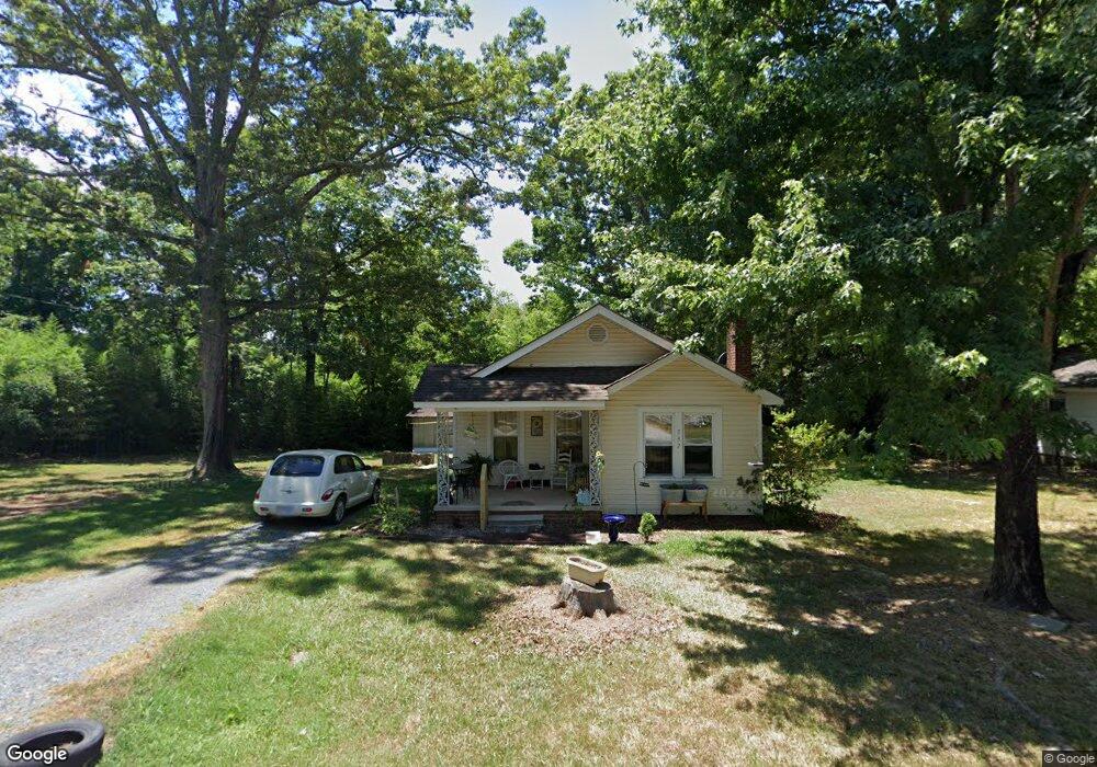
737 N Mccrary St Asheboro, NC 27205
Estimated Value: $148,196 - $168,000
--
Bed
1
Bath
1,032
Sq Ft
$152/Sq Ft
Est. Value
About This Home
This home is located at 737 N Mccrary St, Asheboro, NC 27205 and is currently estimated at $157,049, approximately $152 per square foot. 737 N Mccrary St is a home located in Randolph County with nearby schools including Charles W. McCrary Elementary School, North Asheboro Middle School, and Asheboro High School.
Ownership History
Date
Name
Owned For
Owner Type
Purchase Details
Closed on
Oct 4, 2022
Sold by
Small Barbara Vuncannon and Small Ronald
Bought by
Vuncannon Mark Edward
Current Estimated Value
Purchase Details
Closed on
May 20, 2005
Sold by
Waugh Eric J and Waugh Jenny N
Bought by
Small Barbara Vuncannon
Home Financials for this Owner
Home Financials are based on the most recent Mortgage that was taken out on this home.
Original Mortgage
$59,000
Interest Rate
5.88%
Mortgage Type
Fannie Mae Freddie Mac
Purchase Details
Closed on
Jan 14, 2002
Bought by
Small Barbara
Purchase Details
Closed on
Aug 11, 1999
Bought by
Small Barbara
Create a Home Valuation Report for This Property
The Home Valuation Report is an in-depth analysis detailing your home's value as well as a comparison with similar homes in the area
Home Values in the Area
Average Home Value in this Area
Purchase History
| Date | Buyer | Sale Price | Title Company |
|---|---|---|---|
| Vuncannon Mark Edward | -- | -- | |
| Vuncannon Mark Edward | -- | None Listed On Document | |
| Small Barbara Vuncannon | $77,000 | -- | |
| Small Barbara | $73,500 | -- | |
| Small Barbara | $67,000 | -- |
Source: Public Records
Mortgage History
| Date | Status | Borrower | Loan Amount |
|---|---|---|---|
| Previous Owner | Small Barbara Vuncannon | $59,000 |
Source: Public Records
Tax History Compared to Growth
Tax History
| Year | Tax Paid | Tax Assessment Tax Assessment Total Assessment is a certain percentage of the fair market value that is determined by local assessors to be the total taxable value of land and additions on the property. | Land | Improvement |
|---|---|---|---|---|
| 2025 | $749 | $96,560 | $21,240 | $75,320 |
| 2024 | $739 | $96,560 | $21,240 | $75,320 |
| 2023 | $739 | $96,560 | $21,240 | $75,320 |
| 2022 | $634 | $68,400 | $16,620 | $51,780 |
| 2021 | $634 | $68,400 | $16,620 | $51,780 |
| 2020 | $620 | $68,400 | $16,620 | $51,780 |
| 2019 | $620 | $68,400 | $16,620 | $51,780 |
| 2018 | $608 | $65,190 | $17,990 | $47,200 |
| 2016 | $601 | $65,194 | $17,990 | $47,204 |
| 2015 | $597 | $65,194 | $17,990 | $47,204 |
| 2014 | -- | $65,194 | $17,990 | $47,204 |
Source: Public Records
Map
Nearby Homes
- 1110 Park Dr
- 0 Highwood Dr
- 0000 Little Gate Dr
- 866 Mountain Rd
- 1025 Neely Dr
- 627 Oakmont Dr
- 1407 Oakland Ave
- TBD Oakland Ave
- 1011 Westmont Dr
- 516 and 518 Peachtree St
- 435 Peachtree St
- 1582 Westmont Dr
- 1142 Westover Terrace
- 0 Amity Rd
- 914 Tamworth Rd
- 923 Arnold St
- 330 W Presnell St Unit 37
- 330 13 W Presnell St
- 246 Hampton Rd Unit 8A
- 255 Liberty St
- 747 N Mccrary St
- 719 N Mccrary St
- 759 N Mccrary St
- 738 N Mccrary St
- 740 N Mccrary St
- 752 N Mccrary St
- 728 N Mccrary St
- 738 Lincoln Ave
- 760 N Mccrary St
- 730 Lincoln Ave
- 750 Lincoln Ave
- 712 N Mccrary St
- 709 N Mccrary St
- 724 Lincoln Ave
- 716 Lincoln Ave
- 631 N Mccrary St
- 1002 Park Dr
- 0 Wilson St
- 636 N Mccrary St
- 737 Lincoln Ave