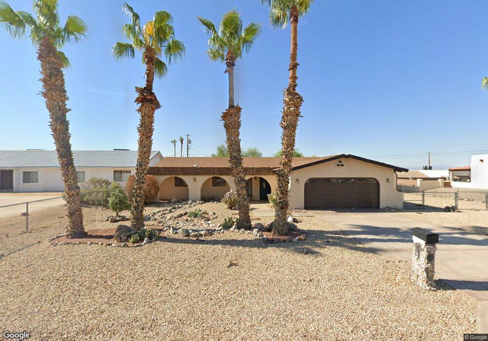
771 Yosemite Dr Lake Havasu City, AZ 86406
Estimated Value: $342,000 - $428,000
3
Beds
1
Bath
1,570
Sq Ft
$254/Sq Ft
Est. Value
About This Home
This home is located at 771 Yosemite Dr, Lake Havasu City, AZ 86406 and is currently estimated at $398,590, approximately $253 per square foot. 771 Yosemite Dr is a home located in Mohave County with nearby schools including Starline Elementary School, Thunderbolt Middle School, and Lake Havasu High School.
Ownership History
Date
Name
Owned For
Owner Type
Purchase Details
Closed on
May 26, 2010
Sold by
Gerba Alex Martin and Gerba Andrea Taylor
Bought by
Koepke James R and Koepke Shirley A
Current Estimated Value
Purchase Details
Closed on
Aug 18, 2004
Sold by
Opie Robert C and Opie Sherrisse D
Bought by
Gerba Alex Martin and Gerba Andrea Taylor
Purchase Details
Closed on
Dec 19, 2003
Sold by
Barnes Anita L
Bought by
Opie Robert C and Opie Sherrisse D
Home Financials for this Owner
Home Financials are based on the most recent Mortgage that was taken out on this home.
Original Mortgage
$90,000
Interest Rate
5.86%
Mortgage Type
New Conventional
Create a Home Valuation Report for This Property
The Home Valuation Report is an in-depth analysis detailing your home's value as well as a comparison with similar homes in the area
Home Values in the Area
Average Home Value in this Area
Purchase History
| Date | Buyer | Sale Price | Title Company |
|---|---|---|---|
| Koepke James R | $125,000 | Chicago Title Insurance Co | |
| Gerba Alex Martin | $186,000 | Capital Title Agency Inc | |
| Opie Robert C | $135,000 | Chicago Title Ins Co |
Source: Public Records
Mortgage History
| Date | Status | Borrower | Loan Amount |
|---|---|---|---|
| Previous Owner | Opie Robert C | $90,000 |
Source: Public Records
Tax History Compared to Growth
Tax History
| Year | Tax Paid | Tax Assessment Tax Assessment Total Assessment is a certain percentage of the fair market value that is determined by local assessors to be the total taxable value of land and additions on the property. | Land | Improvement |
|---|---|---|---|---|
| 2026 | -- | -- | -- | -- |
| 2025 | $1,143 | $34,498 | $0 | $0 |
| 2024 | $1,143 | $33,469 | $0 | $0 |
| 2023 | $1,143 | $26,978 | $0 | $0 |
| 2022 | $1,094 | $19,776 | $0 | $0 |
| 2021 | $1,253 | $17,890 | $0 | $0 |
| 2019 | $1,193 | $14,801 | $0 | $0 |
| 2018 | $1,154 | $13,595 | $0 | $0 |
| 2017 | $1,143 | $12,521 | $0 | $0 |
| 2016 | $1,040 | $11,295 | $0 | $0 |
| 2015 | $998 | $9,698 | $0 | $0 |
Source: Public Records
Map
Nearby Homes
- 680 Yosemite Dr
- 700 Apache Dr
- 2741 Jericho Dr
- 670 Avenida Laredo
- 677 Avenida Laredo
- 2910 Coconino Dr
- 786 Powder Dr
- 2890 Yuma Dr
- 2820 Indian Springs Dr
- 701 Paseo Granada
- 2750 Via Naranja
- 2970 War Eagle Dr
- 1031 Gleneagles Dr
- 2659 Jamaica Blvd S Unit C102
- 2876 Plaza Del Oro
- 2821 Indian Pipe Dr
- 532 Roanoke Dr
- 2721 Southwind Ave
- 1065 Montrose Dr
- 2591 Via Palma
- 761 Yosemite Dr
- 781 Yosemite Dr
- 2778 Diablo Dr
- 2778 Diablo Dr
- 2780 Diablo Dr
- 2770 Diablo Dr
- 791 Yosemite Dr
- 751 Yosemite Dr
- 664 Yosemite Dr
- 668 Yosemite Ct
- 2784 Diablo Dr
- 2764 Diablo Dr
- 658 Yosemite Dr
- 801 Yosemite Dr
- 700 Yosemite Ct
- 2779 Diablo Dr
- 2769 Diablo Dr
- 672 Yosemite Ct
- 2789 Diablo Dr
- 2760 Diablo Dr