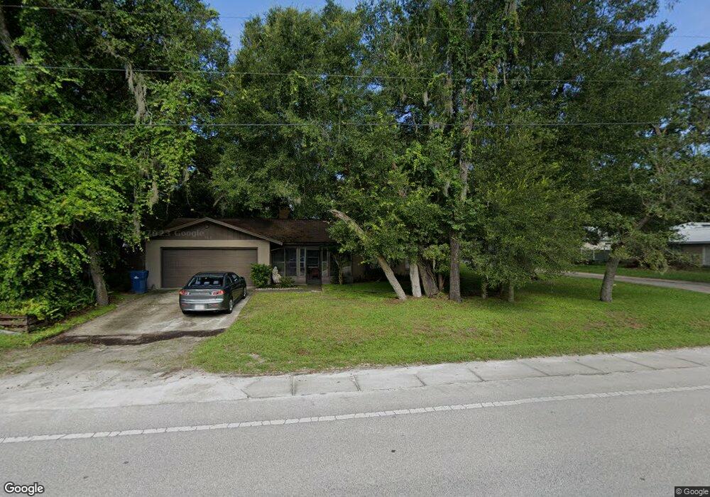
795 Hamilton Ave Orange City, FL 32763
Estimated Value: $250,498 - $272,000
3
Beds
2
Baths
1,165
Sq Ft
$225/Sq Ft
Est. Value
About This Home
This home is located at 795 Hamilton Ave, Orange City, FL 32763 and is currently estimated at $262,125, approximately $225 per square foot. 795 Hamilton Ave is a home located in Volusia County with nearby schools including Orange City Elementary School, River Springs Middle School, and University High School.
Ownership History
Date
Name
Owned For
Owner Type
Purchase Details
Closed on
Sep 6, 2002
Sold by
Ranard Marian D and Ranard Elizabeth M
Bought by
Long Richard A and Long Linda M
Current Estimated Value
Purchase Details
Closed on
Apr 27, 1995
Sold by
Howell Richard L and Howell Vicki L
Bought by
Ranard Marion D and Ranard Elizabeth M
Home Financials for this Owner
Home Financials are based on the most recent Mortgage that was taken out on this home.
Original Mortgage
$64,850
Interest Rate
8.35%
Purchase Details
Closed on
May 15, 1987
Bought by
Long Richard A and Long Linda M
Purchase Details
Closed on
Mar 15, 1982
Bought by
Long Richard A and Long Linda M
Purchase Details
Closed on
Mar 15, 1981
Bought by
Long Richard A and Long Linda M
Create a Home Valuation Report for This Property
The Home Valuation Report is an in-depth analysis detailing your home's value as well as a comparison with similar homes in the area
Home Values in the Area
Average Home Value in this Area
Purchase History
| Date | Buyer | Sale Price | Title Company |
|---|---|---|---|
| Long Richard A | $70,000 | -- | |
| Ranard Marion D | $66,900 | -- | |
| Long Richard A | $58,000 | -- | |
| Long Richard A | $900 | -- | |
| Long Richard A | $1,800 | -- |
Source: Public Records
Mortgage History
| Date | Status | Borrower | Loan Amount |
|---|---|---|---|
| Previous Owner | Ranard Marion D | $64,850 |
Source: Public Records
Tax History Compared to Growth
Tax History
| Year | Tax Paid | Tax Assessment Tax Assessment Total Assessment is a certain percentage of the fair market value that is determined by local assessors to be the total taxable value of land and additions on the property. | Land | Improvement |
|---|---|---|---|---|
| 2025 | $2,978 | $201,065 | $48,555 | $152,510 |
| 2024 | $2,978 | $201,779 | $48,555 | $153,224 |
| 2023 | $2,978 | $198,364 | $37,765 | $160,599 |
| 2022 | $2,739 | $174,801 | $29,880 | $144,921 |
| 2021 | $2,594 | $142,185 | $21,165 | $121,020 |
| 2020 | $2,425 | $135,041 | $13,280 | $121,761 |
| 2019 | $2,363 | $123,805 | $10,920 | $112,885 |
| 2018 | $2,206 | $111,351 | $9,100 | $102,251 |
| 2017 | $1,986 | $87,985 | $7,462 | $80,523 |
| 2016 | $1,734 | $71,932 | $0 | $0 |
| 2015 | $1,623 | $62,880 | $0 | $0 |
| 2014 | $1,467 | $52,944 | $0 | $0 |
Source: Public Records
Map
Nearby Homes
- 00 7th St
- 1171 9th St
- 1261 10th St
- 1275 10th St
- 0 10th St Unit MFRV4941473
- 1600 Ace Park Dr
- 1410 5th St
- 0 9th St
- 711 Sunset Ave
- 571 James St
- 0 Strickland Ave
- 851 W Wisconsin Ave
- 0 14th St Unit 11570263
- 0 14th St Unit MFRS5133079
- 1145 15th St
- 782 Valencia Ave
- 225 White Dove Ave
- 990 W French Ave
- 1425 13th St
- 0 12th St Unit MFRO6299359