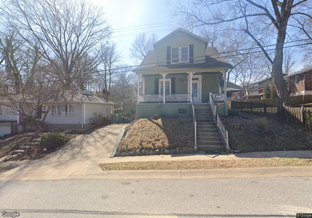
808 N Forest Ave Saint Louis, MO 63119
Estimated Value: $396,030 - $454,000
3
Beds
2
Baths
1,551
Sq Ft
$274/Sq Ft
Est. Value
About This Home
This home is located at 808 N Forest Ave, Saint Louis, MO 63119 and is currently estimated at $424,508, approximately $273 per square foot. 808 N Forest Ave is a home located in St. Louis County with nearby schools including Avery Elementary School, Hixson Middle School, and Webster Groves High School.
Ownership History
Date
Name
Owned For
Owner Type
Purchase Details
Closed on
Nov 25, 2015
Sold by
Love Melinda S
Bought by
Love Melinda S and Melinda S Love Revocable Living Trust
Current Estimated Value
Purchase Details
Closed on
Nov 23, 2015
Sold by
Bryant Sean E
Bought by
Love Melinda S
Purchase Details
Closed on
Aug 21, 2002
Sold by
Freese Timothy E and Freese Monica M
Bought by
Bryant Sean E and Love Melinda S
Home Financials for this Owner
Home Financials are based on the most recent Mortgage that was taken out on this home.
Original Mortgage
$184,775
Interest Rate
6.33%
Purchase Details
Closed on
Jun 30, 1997
Sold by
Mangrum Richard A and Mangrum Maureen L
Bought by
Freese Timothy E and Freese Monica H
Home Financials for this Owner
Home Financials are based on the most recent Mortgage that was taken out on this home.
Original Mortgage
$120,757
Interest Rate
7.92%
Mortgage Type
FHA
Create a Home Valuation Report for This Property
The Home Valuation Report is an in-depth analysis detailing your home's value as well as a comparison with similar homes in the area
Home Values in the Area
Average Home Value in this Area
Purchase History
| Date | Buyer | Sale Price | Title Company |
|---|---|---|---|
| Love Melinda S | -- | None Available | |
| Love Melinda S | -- | None Available | |
| Bryant Sean E | $194,500 | -- | |
| Freese Timothy E | -- | -- |
Source: Public Records
Mortgage History
| Date | Status | Borrower | Loan Amount |
|---|---|---|---|
| Previous Owner | Bryant Sean E | $184,775 | |
| Previous Owner | Freese Timothy E | $120,757 |
Source: Public Records
Tax History Compared to Growth
Tax History
| Year | Tax Paid | Tax Assessment Tax Assessment Total Assessment is a certain percentage of the fair market value that is determined by local assessors to be the total taxable value of land and additions on the property. | Land | Improvement |
|---|---|---|---|---|
| 2025 | $4,192 | $64,040 | $42,470 | $21,570 |
| 2024 | $4,192 | $60,090 | $30,890 | $29,200 |
| 2023 | $4,172 | $60,090 | $30,890 | $29,200 |
| 2022 | $3,971 | $53,100 | $30,890 | $22,210 |
| 2021 | $3,958 | $53,100 | $30,890 | $22,210 |
| 2020 | $4,195 | $52,470 | $30,890 | $21,580 |
| 2019 | $4,165 | $52,470 | $30,890 | $21,580 |
| 2018 | $3,593 | $40,130 | $21,620 | $18,510 |
| 2017 | $3,569 | $40,130 | $21,620 | $18,510 |
| 2016 | $3,298 | $35,480 | $18,530 | $16,950 |
| 2015 | $3,308 | $35,480 | $18,530 | $16,950 |
| 2014 | $3,752 | $39,200 | $13,550 | $25,650 |
Source: Public Records
Map
Nearby Homes
- 835 N Forest Ave
- 840 Marshall Ave
- 716 Clark Ave
- 946 Marshall Ave Unit D
- 940 Brookside Ave
- 808 Greeley Ave
- 8106 Fawn Ave
- 2855 Laclede Station Rd
- 544 Summit Ave
- 2655 Salem Rd
- 619 N Bompart Ave
- 1048 Kuhlman Ln
- 1052 Kuhlman Ln
- 1051 Kuhlman Ln
- 1045 Tuxedo Blvd
- 610 Cornelia Ave
- 570 N Laclede Station Rd
- 554 N Laclede Station Rd
- 2503 Louis Ave
- 1088 Key Ave W
- 810 N Forest Ave
- 1060 Summit Ave
- 1062 Summit Ave
- 1058 Summit Ave
- 812 N Forest Ave
- 809 Eunice Ave
- 813 Eunice Ave
- 1102 Summit Ave
- 1046 Summit Ave
- 824 N Forest Ave
- 817 Eunice Ave
- 821 Eunice Ave
- 813 N Forest Ave
- 750 N Forest Ave
- 1110 Summit Ave
- 828 N Forest Ave
- 755 Eunice Ave
- 755 N Forest Ave
- 1114 Summit Ave
- 751 Eunice Ave