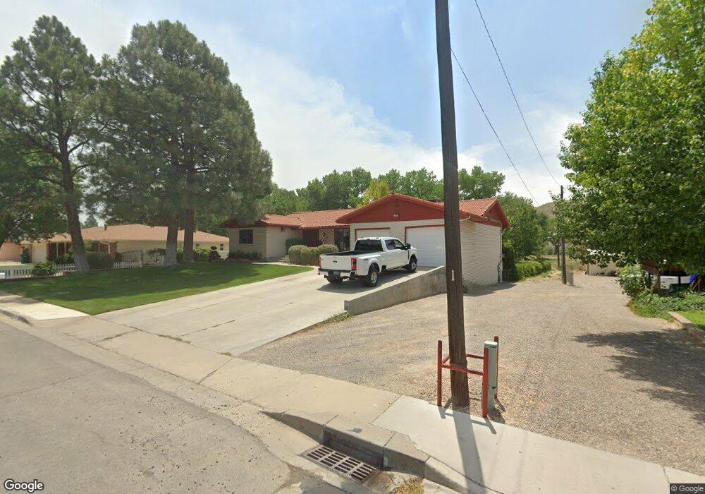
809 Echo Ln Farmington, NM 87401
Estimated Value: $389,000 - $436,000
--
Bed
--
Bath
2,057
Sq Ft
$196/Sq Ft
Est. Value
About This Home
This home is located at 809 Echo Ln, Farmington, NM 87401 and is currently estimated at $402,212, approximately $195 per square foot. 809 Echo Ln is a home located in San Juan County with nearby schools including Apache Elementary School, Tibbetts Middle School, and Farmington High School.
Ownership History
Date
Name
Owned For
Owner Type
Purchase Details
Closed on
Nov 29, 2021
Sold by
Dana And Ann Mcgarrh Trust
Bought by
Dana And Ann Mcgarrh Trust and Mcgarrh
Current Estimated Value
Purchase Details
Closed on
May 11, 2015
Sold by
Hutchins Timothy Mart
Bought by
Hutchins Timothy Mart and Wise Sherry Sue
Purchase Details
Closed on
Jul 14, 2014
Sold by
Gallegos Janet M and Gallegos Thomas W
Bought by
Gallegos Tommy and Gallegos Janet Marie
Purchase Details
Closed on
Apr 30, 2014
Sold by
Duran Johnnie E and Duran Emma Lou
Bought by
Duran Johnnie E and Duran Emma Lou
Create a Home Valuation Report for This Property
The Home Valuation Report is an in-depth analysis detailing your home's value as well as a comparison with similar homes in the area
Home Values in the Area
Average Home Value in this Area
Purchase History
| Date | Buyer | Sale Price | Title Company |
|---|---|---|---|
| Dana And Ann Mcgarrh Trust | -- | None Listed On Document | |
| Mcgarrh Dana A | -- | None Available | |
| Hutchins Timothy Mart | -- | None Available | |
| Gallegos Tommy | -- | None Available | |
| Duran Johnnie E | -- | None Available |
Source: Public Records
Tax History Compared to Growth
Tax History
| Year | Tax Paid | Tax Assessment Tax Assessment Total Assessment is a certain percentage of the fair market value that is determined by local assessors to be the total taxable value of land and additions on the property. | Land | Improvement |
|---|---|---|---|---|
| 2024 | $2,675 | $112,507 | $0 | $0 |
| 2023 | $2,675 | $109,230 | $0 | $0 |
| 2022 | $2,549 | $106,049 | $0 | $0 |
| 2021 | $2,428 | $101,817 | $0 | $0 |
| 2020 | $2,386 | $100,329 | $0 | $0 |
| 2019 | $2,384 | $100,740 | $0 | $0 |
| 2018 | $2,274 | $94,956 | $0 | $0 |
| 2017 | $2,178 | $92,191 | $0 | $0 |
| 2016 | $2,105 | $89,506 | $0 | $0 |
| 2015 | $2,070 | $89,506 | $0 | $0 |
| 2014 | $1,949 | $84,368 | $0 | $0 |
Source: Public Records
Map
Nearby Homes
- 636 Ridge Lea Ct
- 1805 Brenwood Dr
- 2412 Pheasant Place
- 1011 N Auburn Ave
- LOT 4 XX W 24th St
- XX Brookside Dr
- 212 W Sunset Place
- 195 McDonald Rd
- 2413 N Municipal Dr
- 1013 N Orchard Dr
- 200 W 24th St
- 212 W 25th St
- XX W Apache St
- 414 W Comanche St
- 707 W Apache St
- 621 W Apache St
- 1108 N Dustin Ave
- 2900 Northwood Dr
- 511 N Behrend Ave
- 3104 N Western Ave