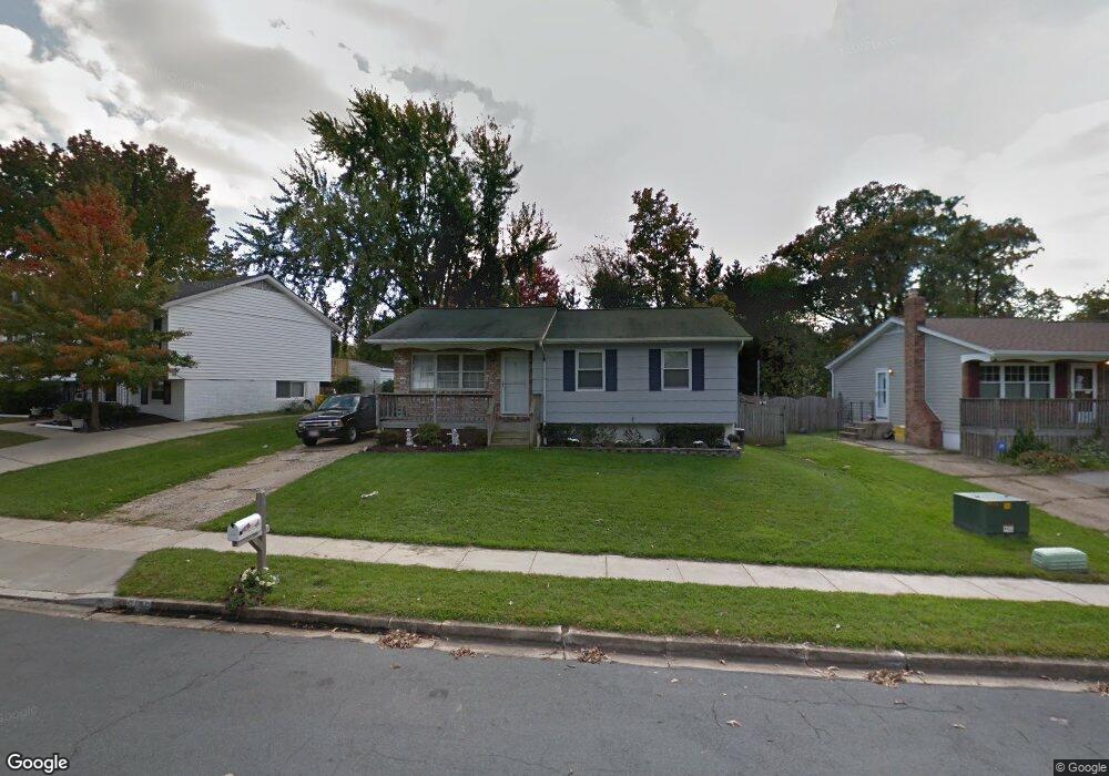
8196 Brandon Dr Millersville, MD 21108
Estimated Value: $416,517 - $471,000
--
Bed
3
Baths
1,416
Sq Ft
$309/Sq Ft
Est. Value
About This Home
This home is located at 8196 Brandon Dr, Millersville, MD 21108 and is currently estimated at $436,879, approximately $308 per square foot. 8196 Brandon Dr is a home located in Anne Arundel County with nearby schools including Rippling Woods Elementary School, Old Mill Middle School North, and Old Mill High School.
Ownership History
Date
Name
Owned For
Owner Type
Purchase Details
Closed on
Jun 23, 2003
Sold by
Lewis Sandra J
Bought by
Genson Darren and Genson Margaret
Current Estimated Value
Purchase Details
Closed on
Nov 24, 1998
Sold by
Lewis Donald W
Bought by
Lewis Sandra J
Purchase Details
Closed on
Sep 19, 1994
Sold by
Liste Linda D F
Bought by
Lewis Donald W
Home Financials for this Owner
Home Financials are based on the most recent Mortgage that was taken out on this home.
Original Mortgage
$138,900
Interest Rate
8.38%
Create a Home Valuation Report for This Property
The Home Valuation Report is an in-depth analysis detailing your home's value as well as a comparison with similar homes in the area
Home Values in the Area
Average Home Value in this Area
Purchase History
| Date | Buyer | Sale Price | Title Company |
|---|---|---|---|
| Genson Darren | $177,000 | -- | |
| Lewis Sandra J | -- | -- | |
| Lewis Donald W | $134,900 | -- |
Source: Public Records
Mortgage History
| Date | Status | Borrower | Loan Amount |
|---|---|---|---|
| Previous Owner | Lewis Donald W | $138,900 | |
| Closed | Genson Darren | -- |
Source: Public Records
Tax History Compared to Growth
Tax History
| Year | Tax Paid | Tax Assessment Tax Assessment Total Assessment is a certain percentage of the fair market value that is determined by local assessors to be the total taxable value of land and additions on the property. | Land | Improvement |
|---|---|---|---|---|
| 2025 | $3,774 | $323,567 | -- | -- |
| 2024 | $3,774 | $298,800 | $196,300 | $102,500 |
| 2023 | $3,677 | $293,333 | $0 | $0 |
| 2022 | $3,438 | $287,867 | $0 | $0 |
| 2021 | $6,763 | $282,400 | $171,300 | $111,100 |
| 2020 | $3,237 | $272,400 | $0 | $0 |
| 2019 | $3,135 | $262,400 | $0 | $0 |
| 2018 | $2,559 | $252,400 | $129,900 | $122,500 |
| 2017 | $2,893 | $246,333 | $0 | $0 |
| 2016 | -- | $240,267 | $0 | $0 |
| 2015 | -- | $234,200 | $0 | $0 |
| 2014 | -- | $234,200 | $0 | $0 |
Source: Public Records
Map
Nearby Homes
- 8421 Norwood Dr
- 525 Old Mill Rd
- 529 Chalet Dr W
- 8218 Sherbrooke Ct
- 565 Belmawr Place
- 494 Kenilworth Ct
- 518 Kenora Dr
- 2664 Carver Rd
- 462 Aventura Ct
- 429 Hardmoore Ct
- Easton Plan at The Willows
- 625 Winding Willow Way
- Potomac Plan at The Willows
- 8283 Longford Rd
- 8281 Longford Rd
- 8279 Longford Rd
- 8275 Longford Rd
- 584 Brightview Dr
- 8267 Longford Rd
- 2 Arrowleaf Dr
- 8194 Brandon Dr
- 8198 Brandon Dr
- 572 Welland Ct
- 8193 Brandon Dr
- 8195 Brandon Dr
- 8191 Brandon Dr
- 8197 Brandon Dr
- 574 Welland Ct
- 8200 Brandon Dr
- 8199 Brandon Dr
- 576 Welland Ct
- 567 Lanny Ct
- 8201 Brandon Dr
- 575 Welland Ct
- 573 Welland Ct
- 565 Lanny Ct
- 8202 Brandon Dr
- 563 Lanny Ct
- 568 Lanny Ct
- 8205 Millfield Ct