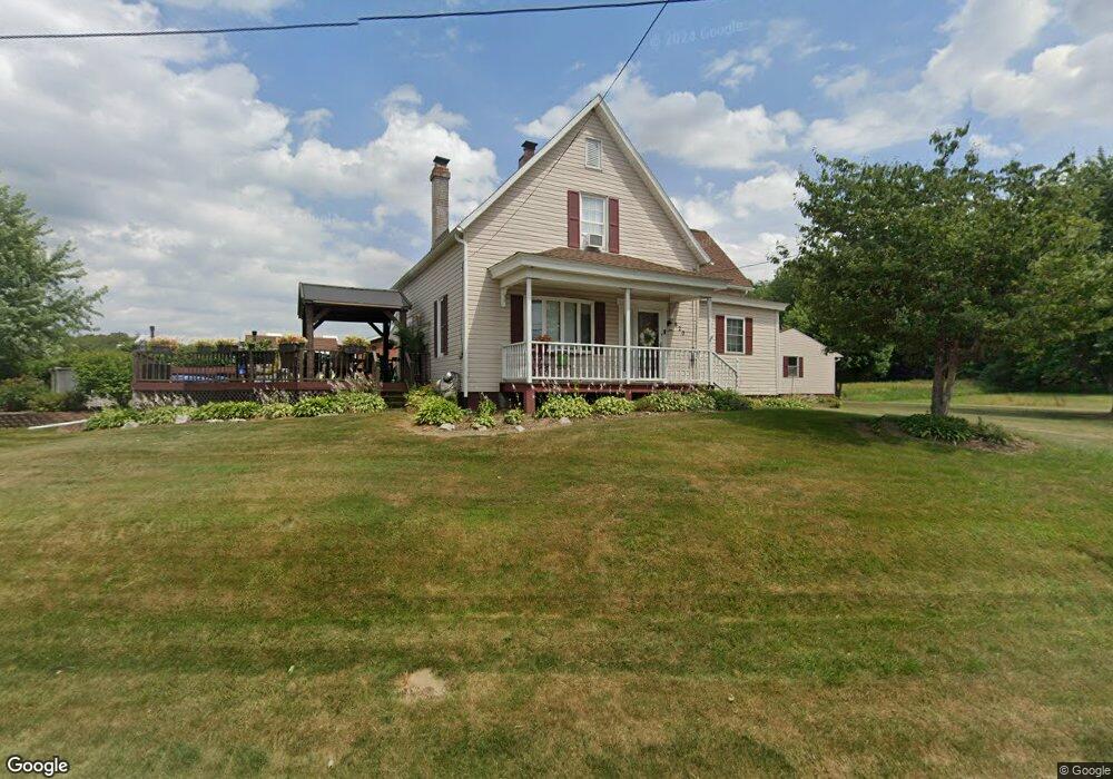
820 N Nickelplate St Louisville, OH 44641
Estimated Value: $212,609 - $238,000
3
Beds
2
Baths
1,367
Sq Ft
$167/Sq Ft
Est. Value
About This Home
This home is located at 820 N Nickelplate St, Louisville, OH 44641 and is currently estimated at $227,652, approximately $166 per square foot. 820 N Nickelplate St is a home located in Stark County with nearby schools including Louisville High School and St. Thomas Aquinas High School & Middle School.
Ownership History
Date
Name
Owned For
Owner Type
Purchase Details
Closed on
Jan 19, 2005
Sold by
Johnson Robert E and Johnson Lucretia
Bought by
Goffus Steven J
Current Estimated Value
Home Financials for this Owner
Home Financials are based on the most recent Mortgage that was taken out on this home.
Original Mortgage
$75,000
Interest Rate
7%
Mortgage Type
Seller Take Back
Purchase Details
Closed on
Dec 15, 1988
Create a Home Valuation Report for This Property
The Home Valuation Report is an in-depth analysis detailing your home's value as well as a comparison with similar homes in the area
Home Values in the Area
Average Home Value in this Area
Purchase History
| Date | Buyer | Sale Price | Title Company |
|---|---|---|---|
| Goffus Steven J | $90,000 | -- | |
| -- | $35,500 | -- |
Source: Public Records
Mortgage History
| Date | Status | Borrower | Loan Amount |
|---|---|---|---|
| Closed | Goffus Steven J | $75,000 |
Source: Public Records
Tax History Compared to Growth
Tax History
| Year | Tax Paid | Tax Assessment Tax Assessment Total Assessment is a certain percentage of the fair market value that is determined by local assessors to be the total taxable value of land and additions on the property. | Land | Improvement |
|---|---|---|---|---|
| 2025 | -- | $61,360 | $19,320 | $42,040 |
| 2024 | -- | $61,360 | $19,320 | $42,040 |
| 2023 | $1,837 | $41,730 | $14,600 | $27,130 |
| 2022 | $921 | $41,730 | $14,600 | $27,130 |
| 2021 | $1,848 | $41,730 | $14,600 | $27,130 |
| 2020 | $1,548 | $37,840 | $13,160 | $24,680 |
| 2019 | $1,556 | $23,980 | $3,360 | $20,620 |
| 2018 | $985 | $23,980 | $3,360 | $20,620 |
| 2017 | $884 | $20,770 | $2,700 | $18,070 |
| 2016 | $902 | $20,770 | $2,700 | $18,070 |
| 2015 | $905 | $20,770 | $2,700 | $18,070 |
| 2014 | $906 | $19,330 | $2,520 | $16,810 |
| 2013 | $456 | $19,330 | $2,520 | $16,810 |
Source: Public Records
Map
Nearby Homes
- 0 Michigan Blvd
- 1170 Winding Ridge Ave
- 910 Crosswyck Cir
- 325 Lincoln Ave
- 308 Superior St
- 2015 E Main St
- 316 E Reno Dr
- 428 Honeycrisp Dr NE
- 3047 Mcintosh Dr NE
- 432 Honeycrisp Dr NE
- 2962 Mcintosh Dr NE
- 2963 Mcintosh Dr NE
- 430 Honeycrisp Dr NE
- 2957 Mcintosh Dr NE
- 520 S Silver St
- 203 Brookfield St
- 641 S Nickelplate St
- 728 E Broad St
- 1715 High St
- 1812 E Broad St
- 0 Nickel Plate Ave NE Unit 3083086
- 0 Nickel Plate Ave NE Unit 3859208
- 0 Nickel Plate Ave NE Unit 3871532
- 0 Nickel Plate Ave NE Unit 4077764
- 802 N Nickelplate St
- 716 N Nickelplate St
- 7070 N Nickel Plate St
- 626 N Nickelplate St
- 624 N Nickelplate St
- 615 Ohio Blvd
- 1143 Ohio Blvd
- 1141 Ohio Blvd
- 620 N Nickelplate St
- 629 Weeburn Way
- 527 Ohio Blvd
- 527 Ohio Blvd
- 527 Ohio Blvd
- 527 Ohio Blvd
- 527 Ohio Blvd
- 641 Weeburn Way