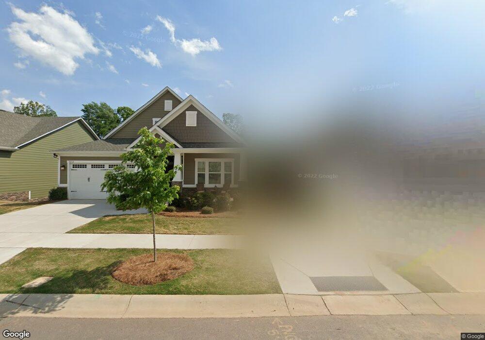
8212 Bretton Woods Dr Charlotte, NC 28227
Estimated Value: $562,000 - $709,000
3
Beds
3
Baths
3,142
Sq Ft
$198/Sq Ft
Est. Value
About This Home
This home is located at 8212 Bretton Woods Dr, Charlotte, NC 28227 and is currently estimated at $623,509, approximately $198 per square foot. 8212 Bretton Woods Dr is a home with nearby schools including Bain Elementary, Mint Hill Middle School, and Independence High.
Ownership History
Date
Name
Owned For
Owner Type
Purchase Details
Closed on
Jul 31, 2019
Sold by
Nvr Inc
Bought by
Madanski David Keith and Madanski Stephanie Anne
Current Estimated Value
Home Financials for this Owner
Home Financials are based on the most recent Mortgage that was taken out on this home.
Original Mortgage
$130,000
Outstanding Balance
$113,926
Interest Rate
3.73%
Mortgage Type
New Conventional
Estimated Equity
$509,583
Purchase Details
Closed on
Apr 3, 2019
Sold by
Charlotte Real Estate Development Llc
Bought by
Nvr Inc
Create a Home Valuation Report for This Property
The Home Valuation Report is an in-depth analysis detailing your home's value as well as a comparison with similar homes in the area
Home Values in the Area
Average Home Value in this Area
Purchase History
| Date | Buyer | Sale Price | Title Company |
|---|---|---|---|
| Madanski David Keith | $400,000 | None Available | |
| Nvr Inc | $147,500 | None Available |
Source: Public Records
Mortgage History
| Date | Status | Borrower | Loan Amount |
|---|---|---|---|
| Open | Madanski David Keith | $130,000 |
Source: Public Records
Tax History Compared to Growth
Tax History
| Year | Tax Paid | Tax Assessment Tax Assessment Total Assessment is a certain percentage of the fair market value that is determined by local assessors to be the total taxable value of land and additions on the property. | Land | Improvement |
|---|---|---|---|---|
| 2025 | $3,315 | $461,200 | $80,000 | $381,200 |
| 2024 | $3,315 | $461,200 | $80,000 | $381,200 |
| 2023 | $3,333 | $471,100 | $80,000 | $391,100 |
| 2022 | $3,606 | $409,100 | $65,000 | $344,100 |
| 2021 | $3,606 | $409,100 | $65,000 | $344,100 |
| 2020 | $3,606 | $65,000 | $65,000 | $0 |
| 2019 | $567 | $65,000 | $65,000 | $0 |
Source: Public Records
Map
Nearby Homes
- 11917 Shady Oak Ct
- Newell Plan at Whitley Preserve - Enclave Collection
- Lemley Plan at Whitley Preserve - Park Collection
- Wyngate Plan at Whitley Preserve - Park Collection
- 12025 Mariner Dr
- Trailwind Plan at Whitley Preserve - Enclave Collection
- Goldrush Plan at Whitley Preserve - Park Collection
- Teasdale Plan at Whitley Preserve - Park Collection
- Whitetail Plan at Whitley Preserve - Enclave Collection
- 12017 Mariner Dr
- 13216 Lawyers Rd
- 17049 Malone Ln
- 18209 Middle Springs Ln
- 18217 Middle Springs Ln
- 4246 Piaffe Ave
- 5926 Long Stirrup Ln
- 5827 Long Stirrup Ln
- 6005 Long Stirrup Ln
- Banks Plan at Alton Creek
- Woodwright Plan at Alton Creek
- 8216 Bretton Woods Dr Unit 61
- 8208 Bretton Woods Dr Unit 63
- 8204 Bretton Woods Dr
- 8204 Bretton Woods Dr Unit 64
- 8220 Bretton Woods Dr
- 8200 Bretton Woods Dr
- 8200 Bretton Woods Dr Unit 65
- 8224 Bretton Woods Dr Unit 59
- 8211 Bretton Woods Dr Unit 88
- 8215 Bretton Woods Dr Unit 87
- 8219 Bretton Woods Dr
- 8228 Bretton Woods Dr
- 8223 Bretton Woods Dr Unit 85
- 8223 Bretton Woods Dr
- 8130 Bretton Woods Dr
- 8227 Bretton Woods Dr
- 6801 Hollow Oak Dr
- 8115 Bretton Woods Dr
- 6811 Hollow Oak Dr
- 8126 Bretton Woods Dr Unit 67