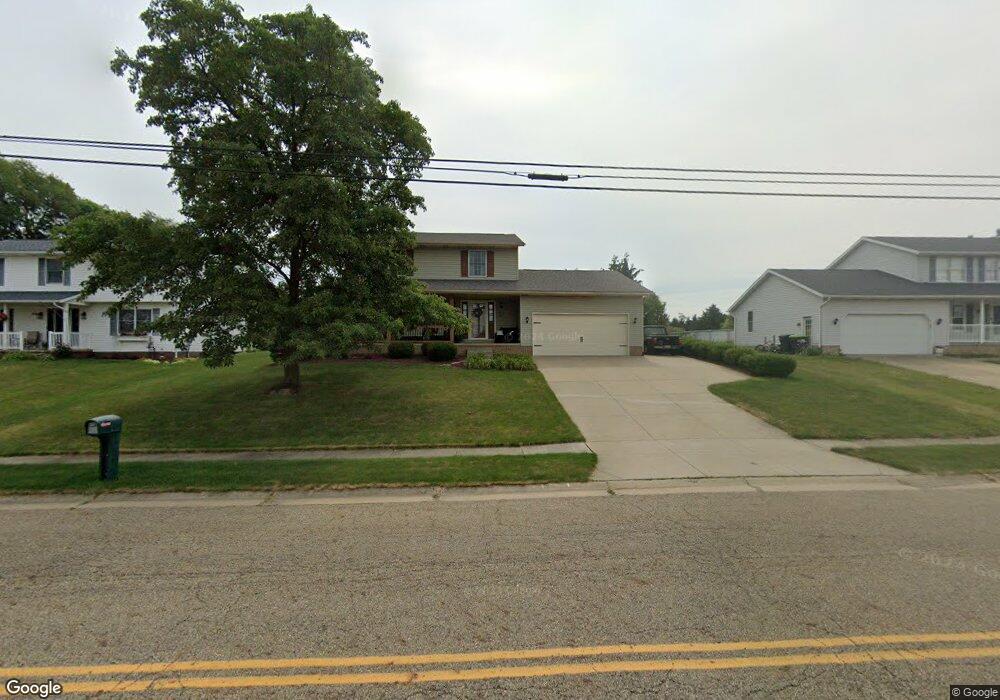
822 Meese Rd Louisville, OH 44641
Estimated Value: $282,000 - $314,000
3
Beds
3
Baths
2,016
Sq Ft
$146/Sq Ft
Est. Value
About This Home
This home is located at 822 Meese Rd, Louisville, OH 44641 and is currently estimated at $293,848, approximately $145 per square foot. 822 Meese Rd is a home located in Stark County with nearby schools including Louisville High School and St. Thomas Aquinas High School & Middle School.
Ownership History
Date
Name
Owned For
Owner Type
Purchase Details
Closed on
Sep 5, 2013
Sold by
Dirocco Michael A and Dirocco Pamela S
Bought by
Dirocco Michael A and Dirocco Pamela S
Current Estimated Value
Purchase Details
Closed on
Apr 8, 1992
Purchase Details
Closed on
Jul 2, 1990
Create a Home Valuation Report for This Property
The Home Valuation Report is an in-depth analysis detailing your home's value as well as a comparison with similar homes in the area
Home Values in the Area
Average Home Value in this Area
Purchase History
| Date | Buyer | Sale Price | Title Company |
|---|---|---|---|
| Dirocco Michael A | -- | None Available | |
| -- | $103,000 | -- | |
| -- | $13,500 | -- |
Source: Public Records
Tax History Compared to Growth
Tax History
| Year | Tax Paid | Tax Assessment Tax Assessment Total Assessment is a certain percentage of the fair market value that is determined by local assessors to be the total taxable value of land and additions on the property. | Land | Improvement |
|---|---|---|---|---|
| 2025 | -- | $79,040 | $15,160 | $63,880 |
| 2024 | -- | $79,040 | $15,160 | $63,880 |
| 2023 | $2,667 | $62,060 | $14,320 | $47,740 |
| 2022 | $2,673 | $62,060 | $14,320 | $47,740 |
| 2021 | $2,680 | $62,060 | $14,320 | $47,740 |
| 2020 | $2,216 | $55,730 | $12,920 | $42,810 |
| 2019 | $2,330 | $58,350 | $12,920 | $45,430 |
| 2018 | $2,321 | $58,350 | $12,920 | $45,430 |
| 2017 | $2,143 | $51,980 | $11,340 | $40,640 |
| 2016 | $2,187 | $51,980 | $11,340 | $40,640 |
| 2015 | $2,193 | $51,980 | $11,340 | $40,640 |
| 2014 | $38 | $44,910 | $9,800 | $35,110 |
| 2013 | $1,023 | $44,910 | $9,800 | $35,110 |
Source: Public Records
Map
Nearby Homes
- 2110 Edmar St
- 1812 E Broad St
- 1715 High St
- 2015 E Main St
- 3390 Meese Rd NE
- 641 S Nickelplate St
- 308 Superior St
- 0 Michigan Blvd
- 520 S Silver St
- 728 E Broad St
- 908 Sand Lot Cir
- 204 E Broad St
- 325 Lincoln Ave
- 107 E Broad St
- 1170 Winding Ridge Ave
- 8225 Georgetown St
- 910 Crosswyck Cir
- 5495 Meese Rd NE
- 1702 View Pointe Ave
- 1639 Horizon Dr
- 832 Meese Rd
- 814 Meese Rd
- 814 Meese Rd NE
- 2212 Briarwood St
- 808 Meese Rd
- 904 Meese Rd
- 2215 Briarwood St
- 909 Meese Rd
- 2202 Briarwood St
- 2205 Briarwood St
- 2128 Briarwood St
- 4201 Meese Rd
- 2133 Briarwood St
- 4221 Meese Rd
- 2118 Briarwood St
- 2125 Briarwood St
- 4221 Meese Rd NE
- 930 Meese Rd NE
- 1048 Century Hill St
- 906 Eastwood Cir