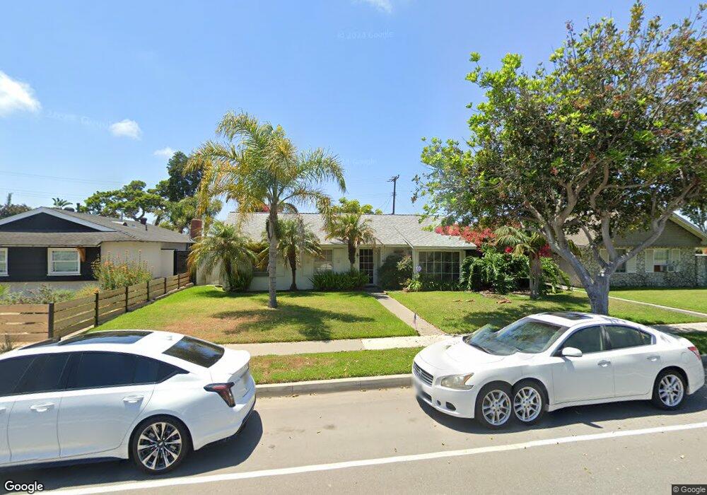
8242 Indianapolis Ave Huntington Beach, CA 92646
Southeast NeighborhoodEstimated Value: $1,132,000 - $1,388,000
3
Beds
2
Baths
1,149
Sq Ft
$1,080/Sq Ft
Est. Value
About This Home
This home is located at 8242 Indianapolis Ave, Huntington Beach, CA 92646 and is currently estimated at $1,241,038, approximately $1,080 per square foot. 8242 Indianapolis Ave is a home located in Orange County with nearby schools including John R. Peterson Elementary, Isaac L. Sowers Middle School, and Edison High School.
Ownership History
Date
Name
Owned For
Owner Type
Purchase Details
Closed on
Feb 23, 2024
Sold by
Wanda A Thornton Trust and Thornton Charles H
Bought by
Thornton Charles H
Current Estimated Value
Purchase Details
Closed on
Jan 19, 2000
Sold by
Northern Trust Bank Of California Na
Bought by
Thornton Wanda A and Wanda A Thornton Trust
Create a Home Valuation Report for This Property
The Home Valuation Report is an in-depth analysis detailing your home's value as well as a comparison with similar homes in the area
Home Values in the Area
Average Home Value in this Area
Purchase History
| Date | Buyer | Sale Price | Title Company |
|---|---|---|---|
| Thornton Charles H | -- | None Listed On Document | |
| Thornton Wanda A | $74,000 | -- |
Source: Public Records
Tax History Compared to Growth
Tax History
| Year | Tax Paid | Tax Assessment Tax Assessment Total Assessment is a certain percentage of the fair market value that is determined by local assessors to be the total taxable value of land and additions on the property. | Land | Improvement |
|---|---|---|---|---|
| 2025 | $1,238 | $78,324 | $36,045 | $42,279 |
| 2024 | $1,238 | $76,789 | $35,339 | $41,450 |
| 2023 | $1,207 | $75,284 | $34,646 | $40,638 |
| 2022 | $1,174 | $73,808 | $33,966 | $39,842 |
| 2021 | $1,154 | $72,361 | $33,300 | $39,061 |
| 2020 | $1,068 | $71,620 | $32,959 | $38,661 |
| 2019 | $1,058 | $70,216 | $32,313 | $37,903 |
| 2018 | $1,041 | $68,840 | $31,680 | $37,160 |
| 2017 | $1,026 | $67,491 | $31,059 | $36,432 |
| 2016 | $990 | $66,168 | $30,450 | $35,718 |
| 2015 | $977 | $65,175 | $29,993 | $35,182 |
| 2014 | $955 | $63,899 | $29,406 | $34,493 |
Source: Public Records
Map
Nearby Homes
- 8342 Seaport Dr
- 20401 Somerville Ln
- 20302 Tidepool Cir Unit 204
- 20371 Bluffside Cir Unit B214
- 8122 Seawater Dr
- 20251 Lighthouse Ln
- 20331 Bluffside Cir Unit 417
- 20331 Bluffside Cir Unit 411
- 20331 Bluffside Cir Unit 222
- 20331 Bluffside Cir Unit A320
- 20331 Bluffside Cir Unit A108
- 20301 Bluffside Cir Unit D312
- 20301 Bluffside Cir Unit D401
- 8565 Colusa Cir Unit 906C
- 20162 S New Britain Ln
- 20251 Cape Coral Ln Unit 315
- 8472 Norfolk Dr
- 1015 Georgia St
- 8565 Trinity Cir Unit 824D
- 8565 Larkhall Cir Unit 804A
- 8252 Indianapolis Ave
- 8232 Indianapolis Ave
- 8262 Indianapolis Ave
- 8241 Reilly Dr
- 8251 Reilly Dr
- 8231 Reilly Dr
- 8261 Reilly Dr
- 8272 Indianapolis Ave
- 8241 Indianapolis Ave
- 8251 Indianapolis Ave
- 8212 Indianapolis Ave
- 8231 Indianapolis Ave
- 8271 Reilly Dr
- 8292 Indianapolis Ave
- 8271 Indianapolis Ave
- 8211 Indianapolis Ave
- 8192 Indianapolis Ave
- 8291 Reilly Dr
- 20562 Farnsworth Ln
- 20561 Goshawk Ln