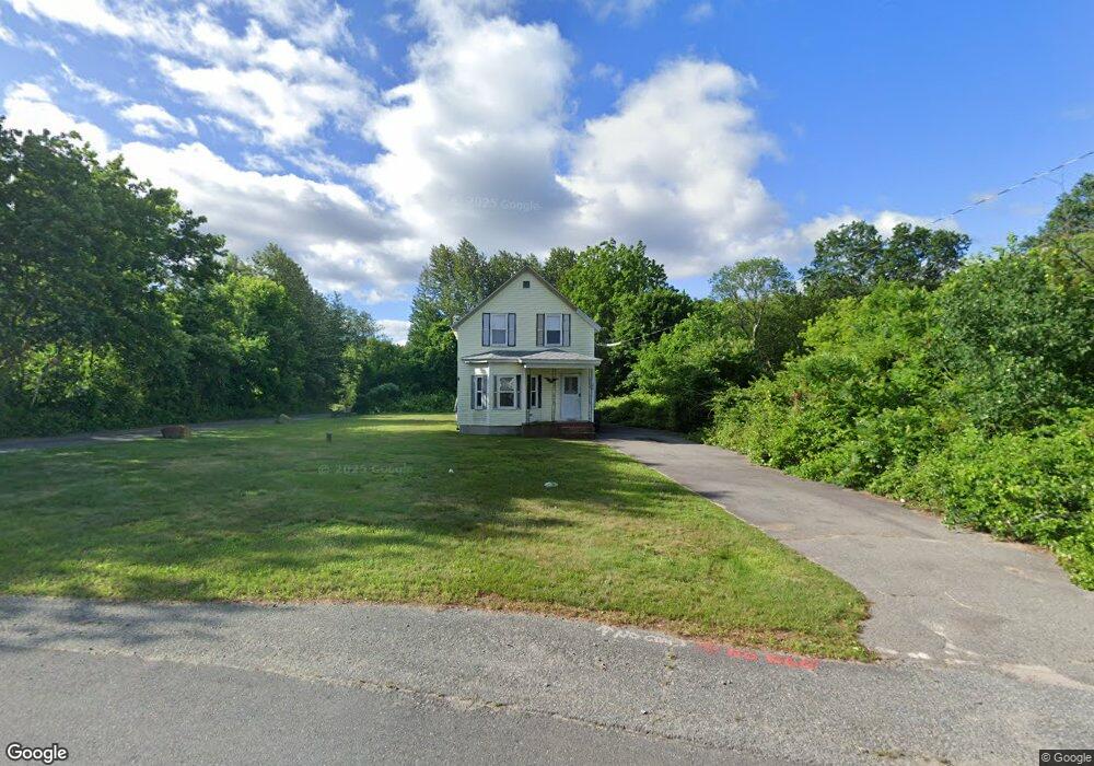
83 Avis Ave Dracut, MA 01826
Estimated Value: $479,456 - $751,000
3
Beds
1
Bath
1,244
Sq Ft
$471/Sq Ft
Est. Value
About This Home
This home is located at 83 Avis Ave, Dracut, MA 01826 and is currently estimated at $585,864, approximately $470 per square foot. 83 Avis Ave is a home located in Middlesex County with nearby schools including Greenmont Avenue School, Richardson Middle School, and Dracut Senior High School.
Ownership History
Date
Name
Owned For
Owner Type
Purchase Details
Closed on
May 2, 2018
Sold by
Dalton Patricia L and Dalton Eugene M
Bought by
Dalton Eugene M
Current Estimated Value
Purchase Details
Closed on
May 6, 1996
Sold by
Vigeant Dorothy
Bought by
Dalton Eugene and Dalton Patricia
Home Financials for this Owner
Home Financials are based on the most recent Mortgage that was taken out on this home.
Original Mortgage
$93,600
Interest Rate
7.82%
Mortgage Type
Purchase Money Mortgage
Create a Home Valuation Report for This Property
The Home Valuation Report is an in-depth analysis detailing your home's value as well as a comparison with similar homes in the area
Home Values in the Area
Average Home Value in this Area
Purchase History
| Date | Buyer | Sale Price | Title Company |
|---|---|---|---|
| Dalton Eugene M | -- | -- | |
| Dalton Eugene | $117,000 | -- |
Source: Public Records
Mortgage History
| Date | Status | Borrower | Loan Amount |
|---|---|---|---|
| Previous Owner | Dalton Eugene | $90,000 | |
| Previous Owner | Dalton Eugene | $93,600 |
Source: Public Records
Tax History Compared to Growth
Tax History
| Year | Tax Paid | Tax Assessment Tax Assessment Total Assessment is a certain percentage of the fair market value that is determined by local assessors to be the total taxable value of land and additions on the property. | Land | Improvement |
|---|---|---|---|---|
| 2025 | $4,256 | $420,600 | $208,500 | $212,100 |
| 2024 | $4,240 | $405,700 | $198,600 | $207,100 |
| 2023 | $4,055 | $350,200 | $172,700 | $177,500 |
| 2022 | $4,021 | $327,200 | $156,900 | $170,300 |
| 2021 | $5,970 | $314,200 | $142,500 | $171,700 |
| 2020 | $4,093 | $306,600 | $138,300 | $168,300 |
| 2019 | $3,772 | $274,300 | $131,600 | $142,700 |
| 2018 | $5,222 | $270,700 | $131,600 | $139,100 |
| 2017 | $4,949 | $270,700 | $131,600 | $139,100 |
| 2016 | $3,614 | $243,500 | $126,600 | $116,900 |
| 2015 | $3,477 | $232,900 | $126,600 | $106,300 |
| 2014 | $3,273 | $225,900 | $126,600 | $99,300 |
Source: Public Records
Map
Nearby Homes
- 167 Betty Ann Ln
- 321 Old Marsh Hill Rd
- 20 Esther Way Unit 11
- 121 Old Marsh Hill Rd
- 19 Esther Way Unit Lot 10
- 26 Frank St
- 67 Lincoln Ln
- 1572 Bridge St
- 109 Meadow Creek Dr
- 67 Foxhill Ln Unit 67
- 315 Broadway Rd Unit 7
- 241 Broadway Rd Unit 50
- 81 Spring Park Ave
- 999 Hildreth St
- 190 Old Rd
- 18 Stone St
- 174 Old Rd
- 157 Old Rd
- 50 Stephen Ave
- 35 Thissell Ave
- 107 Avis Ave
- 117 Avis Ave
- 87 Avis Ave
- 1 Esther Way Unit 1
- 47 Avis Ave
- 53 Avis Ave
- 131 Avis Ave
- 54 Avis Ave
- 122 Avis Ave
- 3 Esther Way
- 3 Esther Way Unit Lot 2
- 139 Avis Ave
- 232 Old Marsh Hill Rd
- 144 Avis Ave
- 4 Esther Way Unit 19
- 43 Avis Ave
- 37 Avis Ave
- 200 Old Marsh Hill Rd
- 6 Esther Way Unit Lot 18
- 50 Avis Ave