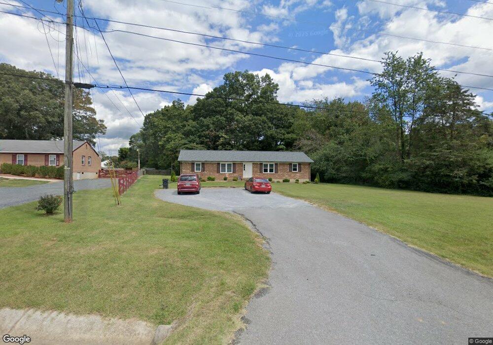
857 Dixie Airport Rd Madison Heights, VA 24572
Estimated Value: $217,521 - $269,000
3
Beds
2
Baths
1,519
Sq Ft
$159/Sq Ft
Est. Value
About This Home
This home is located at 857 Dixie Airport Rd, Madison Heights, VA 24572 and is currently estimated at $242,130, approximately $159 per square foot. 857 Dixie Airport Rd is a home located in Amherst County with nearby schools including Amelon Elementary School, Monelison Middle School, and Amherst County High School.
Ownership History
Date
Name
Owned For
Owner Type
Purchase Details
Closed on
Nov 2, 2020
Sold by
Miller Theta B
Bought by
Miller Theta B
Current Estimated Value
Purchase Details
Closed on
Mar 7, 2013
Sold by
Baldwin Ann D
Bought by
Baldwin Ann D and Ann D Baldwin Revocable Trust
Create a Home Valuation Report for This Property
The Home Valuation Report is an in-depth analysis detailing your home's value as well as a comparison with similar homes in the area
Home Values in the Area
Average Home Value in this Area
Purchase History
| Date | Buyer | Sale Price | Title Company |
|---|---|---|---|
| Miller Theta B | -- | None Available | |
| Baldwin Ann D | -- | None Available |
Source: Public Records
Tax History Compared to Growth
Tax History
| Year | Tax Paid | Tax Assessment Tax Assessment Total Assessment is a certain percentage of the fair market value that is determined by local assessors to be the total taxable value of land and additions on the property. | Land | Improvement |
|---|---|---|---|---|
| 2025 | $707 | $115,900 | $20,000 | $95,900 |
| 2024 | $707 | $115,900 | $20,000 | $95,900 |
| 2023 | $707 | $115,900 | $20,000 | $95,900 |
| 2022 | $707 | $115,900 | $20,000 | $95,900 |
| 2021 | $707 | $115,900 | $20,000 | $95,900 |
| 2020 | $707 | $115,900 | $20,000 | $95,900 |
| 2019 | $670 | $109,800 | $26,000 | $83,800 |
| 2018 | $670 | $109,800 | $26,000 | $83,800 |
| 2017 | $670 | $109,800 | $26,000 | $83,800 |
| 2016 | $670 | $109,800 | $26,000 | $83,800 |
| 2015 | $615 | $109,800 | $26,000 | $83,800 |
| 2014 | $615 | $109,800 | $26,000 | $83,800 |
Source: Public Records
Map
Nearby Homes
- 121 Crestwood Dr
- 250 S Wood Duck Dr
- 571 Dixie Airport Rd
- 0 Commonwealth Dr Unit 361760
- 0 Lot 10 & 11 Stoney Creek Dr Unit 345183
- 164 Glade Rd
- 151 Stratford Place
- 327 Dixie Airport Rd
- 0 Monticello Ln
- 1769 Izaak Walton Rd
- 255 Glade Rd
- TBD Stratford Place Unit 39
- 150 Glenwood Dr
- 272 Dixie Airport Rd
- 289 Todd Ln
- 149 Peaceful Ln
- 172 Stoney Creek Dr
- 0 Izaak Walton Rd
- 11 Stoney Creek Dr
- 10 Stoney Creek Dr
- 853 Dixie Airport Rd
- 867 Dixie Airport Rd
- 848 Dixie Airport Rd
- 858 Dixie Airport Rd
- 914 Possum Island Rd
- 901 Possum Island Rd
- 870 Dixie Airport Rd
- 876 Dixie Airport Rd
- 889 Dixie Airport Rd
- 906 Possum Island Rd
- 896 Dixie Airport Rd
- 887 Possum Island Rd
- 896 Possum Island Rd
- 811 Dixie Airport Rd
- 806 Dixie Airport Rd
- 886 Possum Island Rd
- 879 Possum Island Rd
- 783 Dixie Airport Rd
- 798 Dixie Airport Rd