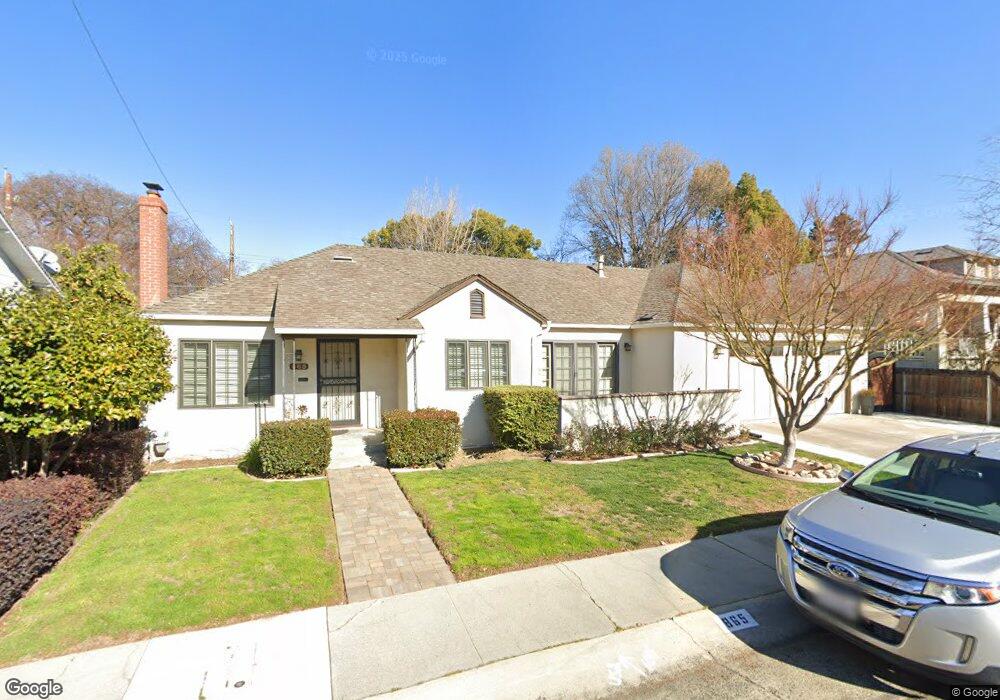
865 9th Ave Sacramento, CA 95818
Upper Land Park NeighborhoodEstimated Value: $607,000 - $1,128,000
4
Beds
2
Baths
3,120
Sq Ft
$279/Sq Ft
Est. Value
About This Home
This home is located at 865 9th Ave, Sacramento, CA 95818 and is currently estimated at $869,392, approximately $278 per square foot. 865 9th Ave is a home located in Sacramento County with nearby schools including Crocker/Riverside Elementary School, California Middle, and C. K. McClatchy High.
Ownership History
Date
Name
Owned For
Owner Type
Purchase Details
Closed on
Jan 12, 2006
Sold by
Starks William G and Starks Lois Lynn
Bought by
Starks William Gerard and Starks Lois Lynn
Current Estimated Value
Purchase Details
Closed on
Sep 30, 2003
Sold by
Starks William G
Bought by
Starks William G and Starks Lois Lynn
Home Financials for this Owner
Home Financials are based on the most recent Mortgage that was taken out on this home.
Original Mortgage
$228,900
Interest Rate
6.22%
Mortgage Type
Purchase Money Mortgage
Create a Home Valuation Report for This Property
The Home Valuation Report is an in-depth analysis detailing your home's value as well as a comparison with similar homes in the area
Home Values in the Area
Average Home Value in this Area
Purchase History
| Date | Buyer | Sale Price | Title Company |
|---|---|---|---|
| Starks William Gerard | -- | None Available | |
| Starks William G | -- | Financial Title Company |
Source: Public Records
Mortgage History
| Date | Status | Borrower | Loan Amount |
|---|---|---|---|
| Closed | Starks William G | $228,900 |
Source: Public Records
Tax History Compared to Growth
Tax History
| Year | Tax Paid | Tax Assessment Tax Assessment Total Assessment is a certain percentage of the fair market value that is determined by local assessors to be the total taxable value of land and additions on the property. | Land | Improvement |
|---|---|---|---|---|
| 2025 | $3,167 | $247,832 | $27,195 | $220,637 |
| 2024 | $3,167 | $242,973 | $26,662 | $216,311 |
| 2023 | $3,095 | $238,210 | $26,140 | $212,070 |
| 2022 | $3,044 | $233,540 | $25,628 | $207,912 |
| 2021 | $2,907 | $228,962 | $25,126 | $203,836 |
| 2020 | $2,926 | $226,615 | $24,869 | $201,746 |
| 2019 | $2,866 | $222,173 | $24,382 | $197,791 |
| 2018 | $2,795 | $217,817 | $23,904 | $193,913 |
| 2017 | $2,758 | $213,547 | $23,436 | $190,111 |
| 2016 | $2,678 | $209,361 | $22,977 | $186,384 |
| 2015 | $2,583 | $206,217 | $22,632 | $183,585 |
| 2014 | $2,517 | $202,178 | $22,189 | $179,989 |
Source: Public Records
Map
Nearby Homes
- 849 8th Ave
- 1032 10th Ave
- 710 7th Ave
- 3098 Riverside Blvd
- 625 Robertson Way
- 2750 Moonflower St
- 2726 Moonflower St
- 1432 Teneighth Way
- 2825 Elderberry St
- 613 Swanston Dr
- The Argo Plan at The Estates at Newport
- The Baltic Plan at The Estates at Newport
- The Caspian Plan at The Estates at Newport
- The Dawson Plan at The Estates at Newport
- 749 3rd Ave Unit 3
- 1259 Milano Dr Unit 2
- 808 Fremont Way
- 1268 Milano Dr Unit 6
- 1701 9th Ave
- 1300 Milano Dr Unit 7