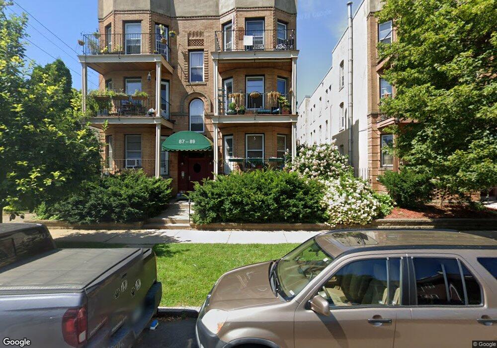
89 Kent St Unit 1 Saint Paul, MN 55102
Summit-University NeighborhoodEstimated Value: $275,723 - $342,000
2
Beds
2
Baths
1,201
Sq Ft
$247/Sq Ft
Est. Value
About This Home
This home is located at 89 Kent St Unit 1, Saint Paul, MN 55102 and is currently estimated at $297,181, approximately $247 per square foot. 89 Kent St Unit 1 is a home located in Ramsey County with nearby schools including Maxfield Magnet Elementary School, Jackson Elementary, and Hidden River Middle School.
Ownership History
Date
Name
Owned For
Owner Type
Purchase Details
Closed on
Feb 26, 2004
Sold by
Parker William L
Bought by
Machnik Julie L
Current Estimated Value
Purchase Details
Closed on
Sep 1, 1986
Sold by
Levine Robert T and Levine Emily H
Bought by
Parker William L
Create a Home Valuation Report for This Property
The Home Valuation Report is an in-depth analysis detailing your home's value as well as a comparison with similar homes in the area
Home Values in the Area
Average Home Value in this Area
Purchase History
| Date | Buyer | Sale Price | Title Company |
|---|---|---|---|
| Machnik Julie L | $230,000 | -- | |
| Parker William L | $55,000 | -- |
Source: Public Records
Mortgage History
| Date | Status | Borrower | Loan Amount |
|---|---|---|---|
| Closed | Parker William L | $0 | |
| Closed | Parker William L | $45,703 |
Source: Public Records
Tax History Compared to Growth
Tax History
| Year | Tax Paid | Tax Assessment Tax Assessment Total Assessment is a certain percentage of the fair market value that is determined by local assessors to be the total taxable value of land and additions on the property. | Land | Improvement |
|---|---|---|---|---|
| 2025 | $3,694 | $250,800 | $1,000 | $249,800 |
| 2023 | $3,694 | $244,800 | $1,000 | $243,800 |
| 2022 | $3,350 | $239,000 | $1,000 | $238,000 |
| 2021 | $3,194 | $221,200 | $1,000 | $220,200 |
| 2020 | $3,330 | $218,300 | $1,000 | $217,300 |
| 2019 | $3,102 | $212,500 | $1,000 | $211,500 |
| 2018 | $2,710 | $198,100 | $1,000 | $197,100 |
| 2017 | $2,602 | $180,200 | $1,000 | $179,200 |
| 2016 | $2,486 | $0 | $0 | $0 |
| 2015 | $2,504 | $168,000 | $16,800 | $151,200 |
| 2014 | $2,668 | $0 | $0 | $0 |
Source: Public Records
Map
Nearby Homes
- 565 Holly Ave
- 545 Holly Ave
- 518 Laurel Ave
- 505 Holly Ave
- 542 Portland Ave
- 496 Holly Ave Unit 1
- 579 Summit Ave Unit 105
- 505 Selby Ave Unit 1
- 676 Ashland Ave Unit 6
- 582 Summit Ave
- 182 MacKubin St Unit 1
- 28 Dale St S Unit A
- 506 Summit Ave
- 28 Saint Albans St N Unit 4N
- 652 Dayton Ave
- 56 Arundel St Unit 10
- 635 Grand Ave Unit 4
- 487 Dayton Ave Unit 1
- 704 Holly Ave
- 214 MacKubin St Unit 214
- 89 Kent St Unit 5
- 89 89 Kent-Street-
- 91 91 Kent St
- 91 Kent St Unit 2
- 91 Kent St Unit 6
- 91 Kent St Unit 4
- 93 Kent St Unit 3
- 93 Kent St Unit 1
- 93 Kent St Unit 5
- 93 93 Kent St
- 87 Kent St
- 87 Kent St Unit 6
- 87 Kent St Unit 4
- 87 Kent St Unit 2
- 576 Ashland Ave Unit 2
- 576 Ashland Ave Unit 1
- 72 72 Kent-Street-
- 72 Kent St Unit 2
- 72 Kent St Unit 1
- 550 Ashland Ave