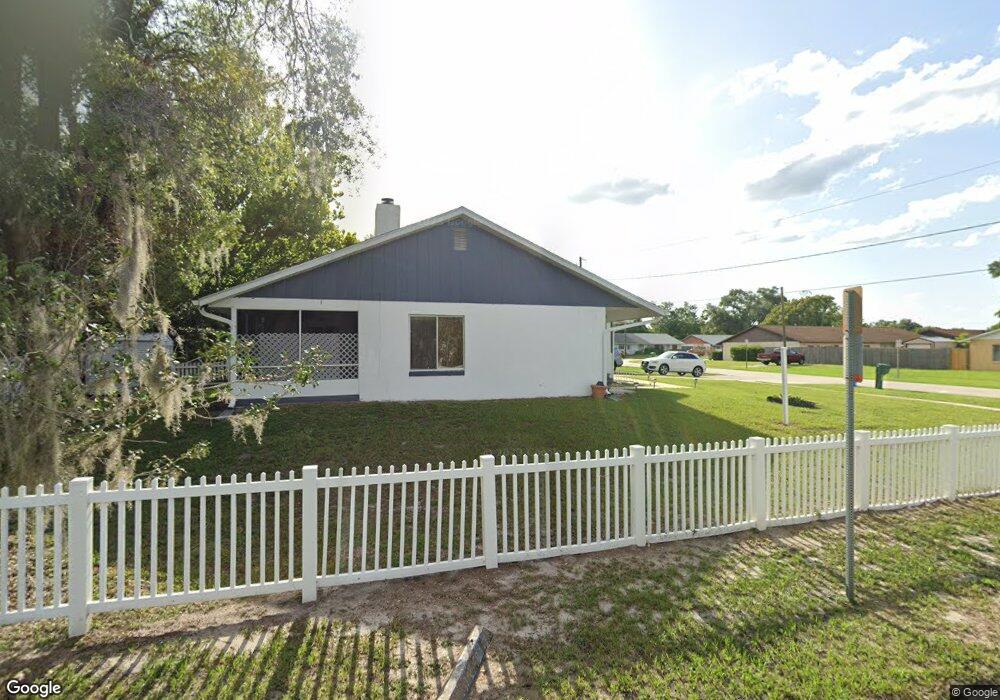
900 Hartford Dr Deland, FL 32724
Estimated Value: $190,000 - $247,000
2
Beds
2
Baths
1,398
Sq Ft
$152/Sq Ft
Est. Value
About This Home
This home is located at 900 Hartford Dr, Deland, FL 32724 and is currently estimated at $212,269, approximately $151 per square foot. 900 Hartford Dr is a home located in Volusia County with nearby schools including Deland High School, George W. Marks Elementary School, and Deland Middle School.
Ownership History
Date
Name
Owned For
Owner Type
Purchase Details
Closed on
Jul 8, 2021
Sold by
Rodriguez William and Maldonado Juan
Bought by
Maldonado Juan
Current Estimated Value
Home Financials for this Owner
Home Financials are based on the most recent Mortgage that was taken out on this home.
Original Mortgage
$60,000
Outstanding Balance
$54,491
Interest Rate
2.96%
Mortgage Type
VA
Estimated Equity
$157,778
Purchase Details
Closed on
Apr 17, 2020
Sold by
Maldonado Lucia and Rodriguez William
Bought by
Maldonado Lucia and Rodriguez William
Purchase Details
Closed on
Mar 6, 2020
Sold by
Maldonado Lucia and Rodriguez William
Bought by
Maldonado Lucia and Rodriguez William
Purchase Details
Closed on
Oct 6, 2015
Sold by
Devlin John P
Bought by
Maldonado Lucia Del Pilar and Rodriguez William
Home Financials for this Owner
Home Financials are based on the most recent Mortgage that was taken out on this home.
Original Mortgage
$47,500
Interest Rate
3.88%
Mortgage Type
New Conventional
Purchase Details
Closed on
May 9, 2006
Sold by
Richards Margrette and Richards Margarette
Bought by
Devlin John P
Home Financials for this Owner
Home Financials are based on the most recent Mortgage that was taken out on this home.
Original Mortgage
$123,500
Interest Rate
6.33%
Mortgage Type
Fannie Mae Freddie Mac
Purchase Details
Closed on
Feb 28, 2006
Sold by
Dixon Terry D and Dykes Thomas J
Bought by
Richards Margarette
Purchase Details
Closed on
Dec 27, 1993
Sold by
Andrews Mary P and Andrews Robert A
Bought by
Conard Johnny A and Conard Barbara
Home Financials for this Owner
Home Financials are based on the most recent Mortgage that was taken out on this home.
Original Mortgage
$89,600
Interest Rate
7.09%
Mortgage Type
Purchase Money Mortgage
Purchase Details
Closed on
Dec 15, 1987
Bought by
Maldonado Lucia Del Pilar
Purchase Details
Closed on
Oct 15, 1987
Bought by
Maldonado Lucia Del Pilar
Purchase Details
Closed on
Nov 15, 1985
Bought by
Maldonado Lucia Del Pilar
Purchase Details
Closed on
Feb 15, 1984
Bought by
Maldonado Lucia Del Pilar
Create a Home Valuation Report for This Property
The Home Valuation Report is an in-depth analysis detailing your home's value as well as a comparison with similar homes in the area
Home Values in the Area
Average Home Value in this Area
Purchase History
| Date | Buyer | Sale Price | Title Company |
|---|---|---|---|
| Maldonado Juan | -- | Servicelink | |
| Maldonado Lucia | -- | Attorney | |
| Maldonado Lucia | -- | Attorney | |
| Maldonado Lucia | -- | Attorney | |
| Maldonado Lucia Del Pilar | $50,000 | Landmark Title Services Llc | |
| Devlin John P | $154,500 | Vision Title Of Deland Llc | |
| Richards Margarette | $150,000 | None Available | |
| Conard Johnny A | $120,000 | -- | |
| Maldonado Lucia Del Pilar | $104,500 | -- | |
| Maldonado Lucia Del Pilar | $14,900 | -- | |
| Maldonado Lucia Del Pilar | $34,400 | -- | |
| Maldonado Lucia Del Pilar | $22,800 | -- |
Source: Public Records
Mortgage History
| Date | Status | Borrower | Loan Amount |
|---|---|---|---|
| Open | Maldonado Juan | $60,000 | |
| Closed | Maldonado Lucia Del Pilar | $47,500 | |
| Previous Owner | Devlin John P | $123,500 | |
| Previous Owner | Conard Johnny A | $89,600 |
Source: Public Records
Tax History Compared to Growth
Tax History
| Year | Tax Paid | Tax Assessment Tax Assessment Total Assessment is a certain percentage of the fair market value that is determined by local assessors to be the total taxable value of land and additions on the property. | Land | Improvement |
|---|---|---|---|---|
| 2025 | -- | $178,005 | $40,000 | $138,005 |
| 2024 | -- | $177,180 | -- | -- |
| 2023 | $2,135 | $172,020 | $30,000 | $142,020 |
| 2022 | $2,135 | $147,045 | $18,000 | $129,045 |
| 2021 | $1,990 | $117,473 | $12,500 | $104,973 |
| 2019 | $1,710 | $94,131 | $10,000 | $84,131 |
| 2018 | $1,610 | $83,967 | $5,000 | $78,967 |
| 2017 | $1,452 | $66,464 | $5,000 | $61,464 |
| 2016 | $1,266 | $55,131 | $0 | $0 |
| 2015 | $1,112 | $46,893 | $0 | $0 |
| 2014 | $1,159 | $48,655 | $0 | $0 |
Source: Public Records
Map
Nearby Homes
- 907 Marlboro Dr
- 818 Eastover Cir
- 915 Marlboro Dr
- 927 Azalea Walk Cir
- 931 Azalea Walk Cir
- 1103 Lindley Cove Cir
- 708 Montreville Ave
- 851 E Pennsylvania Ave
- 717 E Grove Place
- 1150 Orangewood Ave
- 1005 Crescent Pkwy
- 1007 Crescent Pkwy
- 753 Mystic Oaks Ln
- 612 E Plymouth Ave
- 605 John Thomas Ave
- 1100 E University Ave
- 528 Compton Ct
- 714 Astoria Dr
- 505 E Plymouth Ave
- 45 S University Cir
- 902 Hartford Dr
- 904 Hartford Dr
- 901 Marlboro Dr
- 906 New Bedford Dr
- 906 Hartford Dr
- 907 Hartford Dr
- 903 Marlboro Dr
- 907 New Bedford Dr
- 908 Hartford Dr
- 905 Marlboro Dr
- 909 Hartford Dr
- 909 New Bedford Dr
- 914 New Bedford Dr
- 916 New Bedford Dr
- 913 Hartford Dr
- 906 Marlboro Dr
- 913 New Bedford Dr
- 908 Marlboro Dr
- 915 Hartford Dr
- 912 Hartford Dr