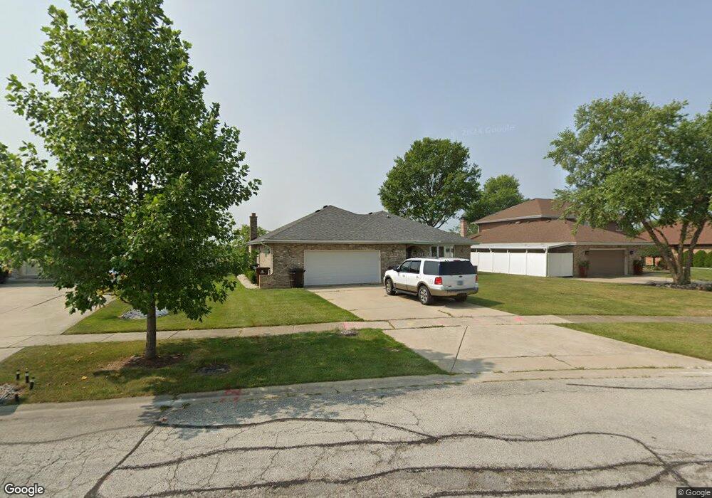
9031 Linden Dr Tinley Park, IL 60487
Central Tinley Park NeighborhoodEstimated Value: $420,000 - $445,000
3
Beds
3
Baths
1,938
Sq Ft
$222/Sq Ft
Est. Value
About This Home
This home is located at 9031 Linden Dr, Tinley Park, IL 60487 and is currently estimated at $430,545, approximately $222 per square foot. 9031 Linden Dr is a home located in Cook County with nearby schools including Christa Mcauliffe School, Prairie View Middle School, and Victor J Andrew High School.
Ownership History
Date
Name
Owned For
Owner Type
Purchase Details
Closed on
Oct 12, 2025
Sold by
Hilton James L and Hilton Patricia A
Bought by
Hilton James L and Hilton Patricia A
Current Estimated Value
Purchase Details
Closed on
Jun 24, 2015
Sold by
Hilton James L and Hilton Patricia A
Bought by
Hilton James L and Hilton Patricia A
Create a Home Valuation Report for This Property
The Home Valuation Report is an in-depth analysis detailing your home's value as well as a comparison with similar homes in the area
Home Values in the Area
Average Home Value in this Area
Purchase History
| Date | Buyer | Sale Price | Title Company |
|---|---|---|---|
| Hilton James L | -- | None Listed On Document | |
| Hilton James L | $16,000 | National Title Solutions Inc |
Source: Public Records
Tax History Compared to Growth
Tax History
| Year | Tax Paid | Tax Assessment Tax Assessment Total Assessment is a certain percentage of the fair market value that is determined by local assessors to be the total taxable value of land and additions on the property. | Land | Improvement |
|---|---|---|---|---|
| 2024 | $8,432 | $37,000 | $6,570 | $30,430 |
| 2023 | $6,556 | $37,000 | $6,570 | $30,430 |
| 2022 | $6,556 | $25,231 | $5,749 | $19,482 |
| 2021 | $6,407 | $25,230 | $5,748 | $19,482 |
| 2020 | $6,394 | $25,230 | $5,748 | $19,482 |
| 2019 | $6,573 | $26,441 | $5,201 | $21,240 |
| 2018 | $6,429 | $26,441 | $5,201 | $21,240 |
| 2017 | $8,163 | $29,801 | $5,201 | $24,600 |
| 2016 | $6,439 | $22,599 | $4,653 | $17,946 |
| 2015 | $6,317 | $22,599 | $4,653 | $17,946 |
| 2014 | $6,286 | $22,599 | $4,653 | $17,946 |
| 2013 | $6,531 | $25,004 | $4,653 | $20,351 |
Source: Public Records
Map
Nearby Homes
- 17533 Pecan Ln
- 17964 Upland Dr
- 9280 Windsor Pkwy Unit 92
- 18055 Upland Dr
- 9260 Windsor Pkwy Unit 80
- 17631 Dover Ct
- 9201 175th St
- 9038 Mansfield Dr Unit 8
- Fremont Plan at Radcliffe Place
- Calysta Plan at Radcliffe Place
- Danbury Plan at Radcliffe Place
- Briarcliffe Plan at Radcliffe Place
- Eden Plan at Radcliffe Place
- Amberwood Plan at Radcliffe Place
- 9051 Mansfield Dr Unit 1
- 18248 Murphy Cir Unit 182
- 17535 S La Grange Rd
- 17535-2 Lagrange Rd
- 17230 Shetland Dr
- 17500 Lagrange Rd
- 9025 Linden Dr
- 9037 Linden Dr
- 9019 Linden Dr
- 9043 Linden Dr
- 9030 Linden Dr
- 9024 Linden Dr
- 9013 Linden Dr
- 9046 Linden Dr
- 9018 Linden Dr
- 9049 Linden Dr
- 9007 Linden Dr
- 9012 Linden Dr
- 9031 Poplar St
- 9025 Poplar St
- 9019 Poplar St
- 17855 Elmwood Dr
- 17849 Elmwood Dr
- 9006 Linden Dr
- 17843 Elmwood Dr
- 9055 Linden Dr