Estimated Value: $396,000 - $424,623
2
Beds
1
Bath
900
Sq Ft
$455/Sq Ft
Est. Value
About This Home
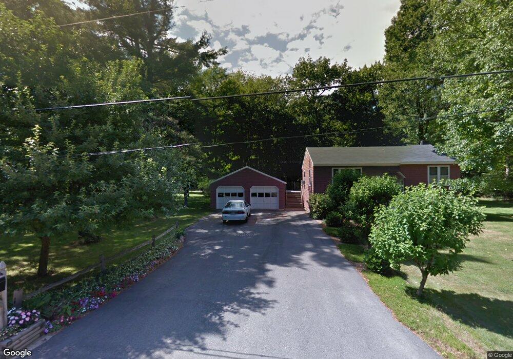
This home is located at 92 Hardwood Dr, Wells, ME 04090 and is currently estimated at $409,156, approximately $454 per square foot. 92 Hardwood Dr is a home located in York County with nearby schools including Wells Elementary School, Wells Junior High School, and Wells High School.
Ownership History
Date
Name
Owned For
Owner Type
Purchase Details
Closed on
Apr 10, 2024
Sold by
Landry Dale
Bought by
Landry Empire T and Landry
Current Estimated Value
Purchase Details
Closed on
Sep 16, 2023
Sold by
Roger C Lincoln Ret and Shepherd
Bought by
Landry Dale
Purchase Details
Closed on
Jun 21, 2012
Sold by
Lincoln Roger C
Bought by
Roger C Lincoln Sr Ret and Lincoln
Create a Home Valuation Report for This Property
The Home Valuation Report is an in-depth analysis detailing your home's value as well as a comparison with similar homes in the area
Home Values in the Area
Average Home Value in this Area
Purchase History
| Date | Buyer | Sale Price | Title Company |
|---|---|---|---|
| Landry Empire T | -- | None Available | |
| Landry Empire T | -- | None Available | |
| Landry Dale | -- | None Available | |
| Landry Dale | -- | None Available | |
| Landry Dale | -- | None Available | |
| Roger C Lincoln Sr Ret | -- | -- | |
| Roger C Lincoln Sr Ret | -- | -- |
Source: Public Records
Tax History Compared to Growth
Tax History
| Year | Tax Paid | Tax Assessment Tax Assessment Total Assessment is a certain percentage of the fair market value that is determined by local assessors to be the total taxable value of land and additions on the property. | Land | Improvement |
|---|---|---|---|---|
| 2024 | $2,004 | $329,540 | $131,430 | $198,110 |
| 2023 | $1,964 | $329,540 | $131,430 | $198,110 |
| 2022 | $1,736 | $165,960 | $59,700 | $106,260 |
| 2021 | $1,746 | $165,960 | $56,190 | $109,770 |
| 2020 | $1,739 | $165,960 | $59,700 | $106,260 |
| 2019 | $1,729 | $165,960 | $59,700 | $106,260 |
| 2018 | $1,682 | $165,960 | $59,700 | $106,260 |
| 2017 | $1,686 | $165,960 | $59,700 | $106,260 |
| 2016 | $1,670 | $165,960 | $59,700 | $106,260 |
| 2015 | $1,651 | $165,960 | $59,700 | $106,260 |
| 2013 | $1,514 | $165,960 | $59,700 | $106,260 |
Source: Public Records
Map
Nearby Homes
- 93 Natanis Ridge Cir
- Lot 2 Rolling Woods Ln
- Lot 7 Rolling Woods Ln
- Lot A Rolling Woods Ln
- Lot 13 Rolling Woods Ln
- Lot 17 Rolling Woods Ln
- Lot 3 Rolling Woods Ln
- Lot 4 Rolling Woods Ln
- Lot 9 Rolling Woods Ln
- Lot 15 Rolling Woods Ln
- Lot 1 Rolling Woods Ln
- Lot 6 Rolling Woods Ln
- Lot 10 Rolling Woods Ln
- Lot 11 Rolling Woods Ln
- Lot 16 Rolling Woods Ln
- Lot 14 Rolling Woods Ln
- Lot 12 Rolling Woods Ln
- Lot 5 Rolling Woods Ln
- Lot 8 Rolling Woods Ln
- 99 Westhaven Ln
- 82 Hardwood Dr
- 69 Hardwood Dr
- 70 Hardwood Dr
- 116 Hardwood Dr
- 51 Hardwood Dr
- 98 Glenwood Rd
- 10 Searfoss Ln
- 87 Hardwood Dr
- 108 Glenwood Rd
- 44 Hardwood Dr
- 132 Glenwood Rd
- 306 Natanis Ridge Cir
- 11 Natanis Ridge Cir
- 27 Searfoss Ln
- 107 Glenwood Rd
- 11 Searfoss Ln
- 0 Natanis Ridge Cir
- 0 Natanis Ridge
- 286 Natanis Ridge Cir
- 79 Glenwood Rd