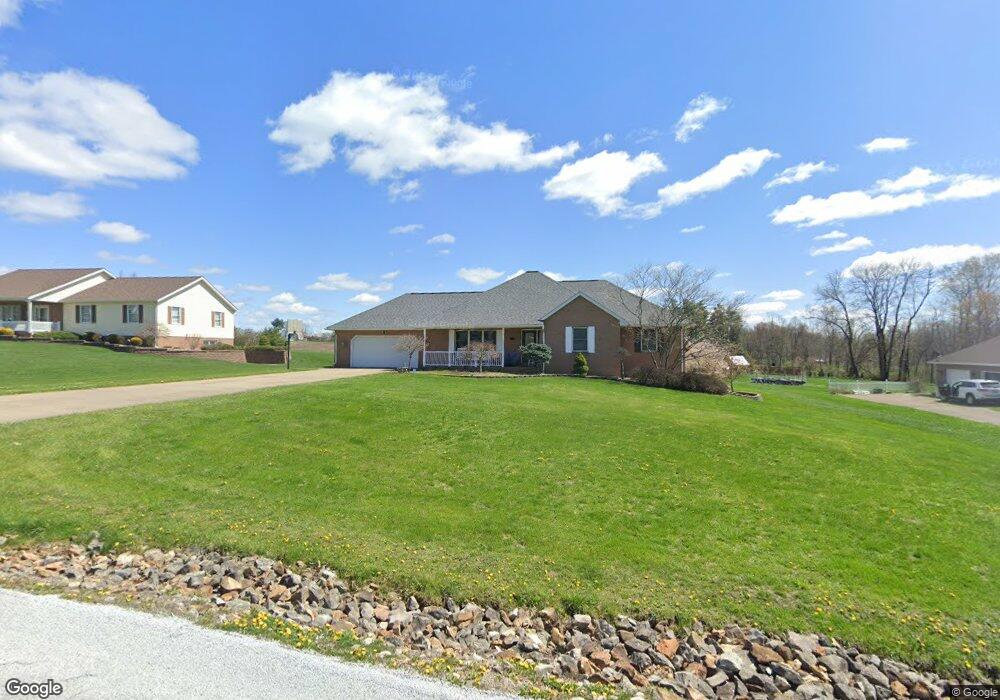
920 Newport Dr Zanesville, OH 43701
Estimated Value: $292,000 - $465,246
3
Beds
3
Baths
1,724
Sq Ft
$235/Sq Ft
Est. Value
About This Home
This home is located at 920 Newport Dr, Zanesville, OH 43701 and is currently estimated at $404,562, approximately $234 per square foot. 920 Newport Dr is a home located in Muskingum County with nearby schools including National Road Elementary School, Zanesville Middle School, and Zanesville High School.
Ownership History
Date
Name
Owned For
Owner Type
Purchase Details
Closed on
Jun 24, 2024
Sold by
Vando Dat and Vu Thu Thi
Bought by
Vando Dat and Vu Thu Thi
Current Estimated Value
Purchase Details
Closed on
Sep 3, 2003
Sold by
Smith Brenda J
Bought by
Vando Dat and Vu Thu Thi
Home Financials for this Owner
Home Financials are based on the most recent Mortgage that was taken out on this home.
Original Mortgage
$146,000
Interest Rate
5.97%
Mortgage Type
Purchase Money Mortgage
Purchase Details
Closed on
Mar 30, 2000
Sold by
Offenbacher John
Bought by
Patterson Tempest W and Patterson Dixie L
Purchase Details
Closed on
May 11, 1999
Sold by
Welker Gregory A
Bought by
Offenbacher John and Offenbacher Linda
Create a Home Valuation Report for This Property
The Home Valuation Report is an in-depth analysis detailing your home's value as well as a comparison with similar homes in the area
Home Values in the Area
Average Home Value in this Area
Purchase History
| Date | Buyer | Sale Price | Title Company |
|---|---|---|---|
| Vando Dat | -- | None Listed On Document | |
| Vando Dat | -- | None Listed On Document | |
| Vando Dat | $182,500 | -- | |
| Patterson Tempest W | $23,000 | -- | |
| Offenbacher John | $30,000 | -- |
Source: Public Records
Mortgage History
| Date | Status | Borrower | Loan Amount |
|---|---|---|---|
| Previous Owner | Vando Dat | $146,000 |
Source: Public Records
Tax History Compared to Growth
Tax History
| Year | Tax Paid | Tax Assessment Tax Assessment Total Assessment is a certain percentage of the fair market value that is determined by local assessors to be the total taxable value of land and additions on the property. | Land | Improvement |
|---|---|---|---|---|
| 2024 | $4,547 | $117,985 | $10,150 | $107,835 |
| 2023 | $4,078 | $98,280 | $8,855 | $89,425 |
| 2022 | $4,001 | $98,280 | $8,855 | $89,425 |
| 2021 | $3,968 | $98,280 | $8,855 | $89,425 |
| 2020 | $3,574 | $85,470 | $7,700 | $77,770 |
| 2019 | $3,573 | $85,470 | $7,700 | $77,770 |
| 2018 | $3,139 | $85,470 | $7,700 | $77,770 |
| 2017 | $2,843 | $66,080 | $7,700 | $58,380 |
| 2016 | $2,784 | $66,080 | $7,700 | $58,380 |
| 2015 | $2,784 | $66,080 | $7,700 | $58,380 |
| 2013 | $2,762 | $59,220 | $7,700 | $51,520 |
Source: Public Records
Map
Nearby Homes
- 1605 Jackson Rd
- 2870 Cody Dr
- 3620 Old Wheeling Rd
- 2755 N Lawndale Place
- 2835 Adamsville Rd
- 2397 Adamsville Rd
- 496 Pleasant Grove Rd
- 2230 Adamsville Rd
- 240 Mockingbird Hill
- 2850 Watson Way
- 360 Walters Way
- 365 Walters Way
- 4460 East Pike
- 2425 S Pleasant Grove Rd
- 0 East Pike Unit 5163133
- 2465 Clay Pike
- 130 Airport Rd
- 0 Bateman Rd
- 0 Sonora Rd Unit 225018643
- 0 Sonora Rd Unit 5125925