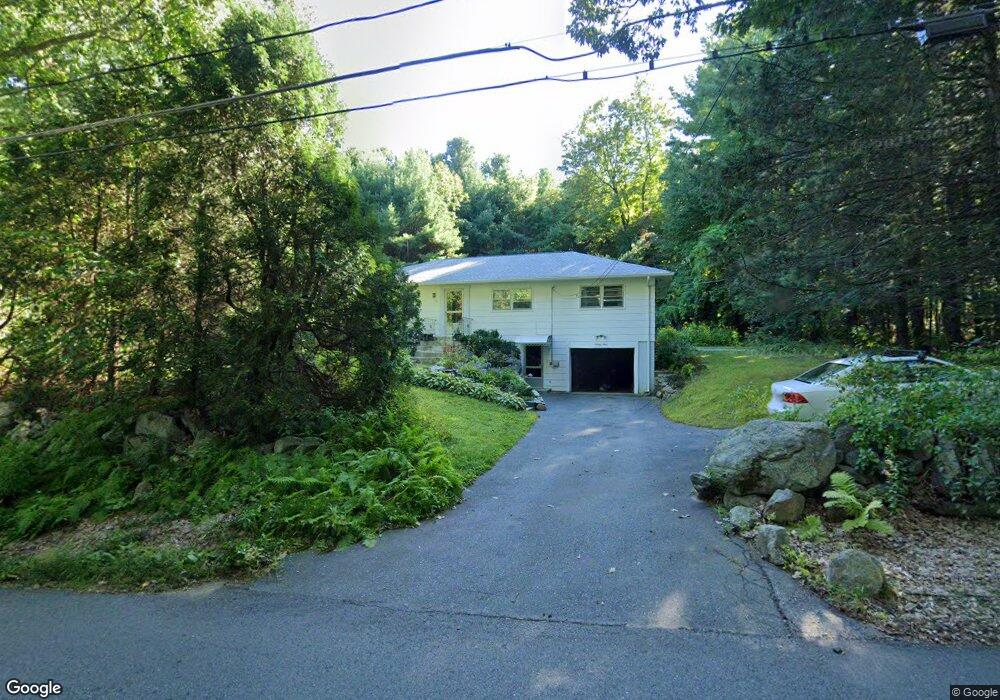
94 Putnam Rd Holden, MA 01520
Estimated Value: $414,000 - $513,000
3
Beds
1
Bath
1,300
Sq Ft
$349/Sq Ft
Est. Value
About This Home
This home is located at 94 Putnam Rd, Holden, MA 01520 and is currently estimated at $453,661, approximately $348 per square foot. 94 Putnam Rd is a home located in Worcester County with nearby schools including Wachusett Regional High School, Holden Christian Academy, and Notre Dame Academy.
Ownership History
Date
Name
Owned For
Owner Type
Purchase Details
Closed on
Aug 18, 2005
Sold by
Garabedian Dennis Robert and Garabedian Robert D
Bought by
Popov Elena and Popov Sergei
Current Estimated Value
Home Financials for this Owner
Home Financials are based on the most recent Mortgage that was taken out on this home.
Original Mortgage
$224,000
Outstanding Balance
$117,670
Interest Rate
5.66%
Mortgage Type
Purchase Money Mortgage
Estimated Equity
$335,991
Create a Home Valuation Report for This Property
The Home Valuation Report is an in-depth analysis detailing your home's value as well as a comparison with similar homes in the area
Home Values in the Area
Average Home Value in this Area
Purchase History
| Date | Buyer | Sale Price | Title Company |
|---|---|---|---|
| Popov Elena | $280,000 | -- |
Source: Public Records
Mortgage History
| Date | Status | Borrower | Loan Amount |
|---|---|---|---|
| Open | Popov Elena | $224,000 |
Source: Public Records
Tax History Compared to Growth
Tax History
| Year | Tax Paid | Tax Assessment Tax Assessment Total Assessment is a certain percentage of the fair market value that is determined by local assessors to be the total taxable value of land and additions on the property. | Land | Improvement |
|---|---|---|---|---|
| 2025 | $5,005 | $361,100 | $135,200 | $225,900 |
| 2024 | $4,679 | $330,700 | $131,200 | $199,500 |
| 2023 | $4,519 | $301,500 | $114,100 | $187,400 |
| 2022 | $4,382 | $264,600 | $89,300 | $175,300 |
| 2021 | $4,235 | $243,400 | $85,000 | $158,400 |
| 2020 | $3,905 | $229,700 | $80,900 | $148,800 |
| 2019 | $3,839 | $220,000 | $80,900 | $139,100 |
| 2018 | $3,584 | $203,500 | $77,100 | $126,400 |
| 2017 | $3,495 | $198,700 | $77,100 | $121,600 |
| 2016 | $3,281 | $190,200 | $73,400 | $116,800 |
| 2015 | $3,272 | $180,600 | $73,400 | $107,200 |
| 2014 | $3,206 | $180,600 | $73,400 | $107,200 |
Source: Public Records
Map
Nearby Homes
- 168 Twinbrooke Dr
- 10 Sumac Cir
- 289 Bailey Rd
- 48 Lexington Cir
- 527 Salisbury St
- 47 Banbury Ln
- 0 Chapin Rd
- 7 Holmes Dr
- 35 Chapin Rd
- 9 Holmes Dr
- 156 Newell Rd
- 8 Dawson Cir
- 124 Bailey Rd
- 33 Thorny Lea Rd
- 216 Reservoir St Unit 103
- 216 Reservoir St Unit 309
- 8 (Lot 1) Holmes Dr
- 23 Gail Dr
- 2 Explorers Way Unit 2
- 68 Fisher Rd
- 82 Putnam Rd
- 93 Putnam Rd
- 86 Putnam Rd
- 103 Putnam Rd
- 195 Twinbrooke Dr
- 116 Putnam Rd
- 31 Gallair Cir
- 200 Twinbrook Dr
- 68 Putnam Rd
- 115 Putnam Rd
- 27 Gallair Cir
- 171 Twinbrooke Dr
- 117 Putnam Rd
- 117 Putnam Rd Unit 1
- 200 Twinbrooke Dr
- 80 Putnam Ln
- 28 Gallair Cir
- 157 Twinbrooke Dr
- 62 Putnam Rd
- 126 Putnam Rd