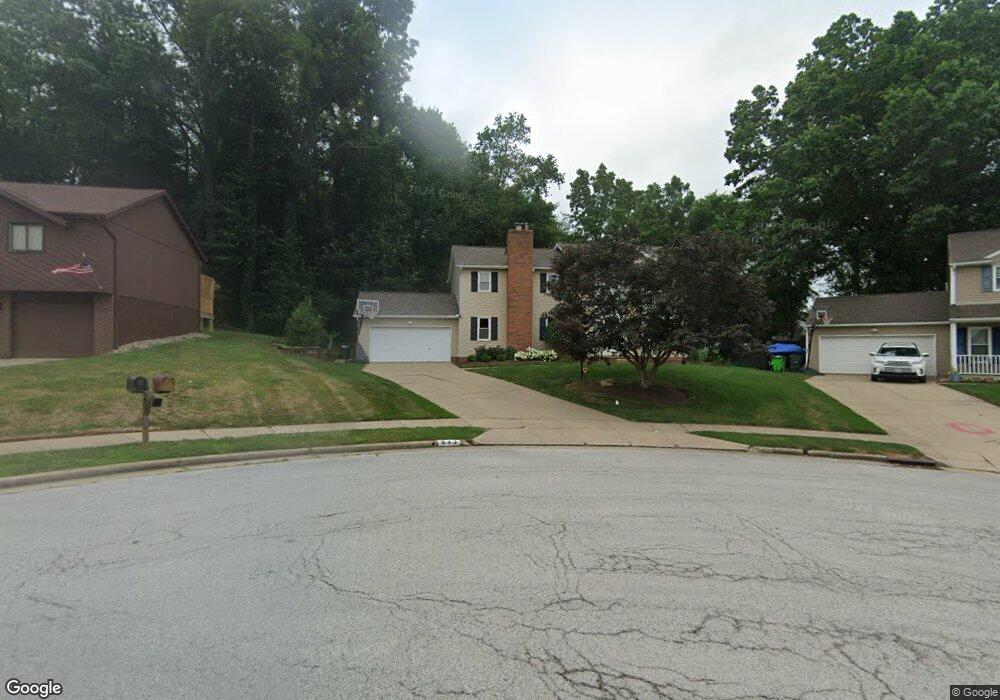
943 Liberty Ln NW North Canton, OH 44720
Estimated Value: $290,512 - $361,000
3
Beds
3
Baths
2,186
Sq Ft
$153/Sq Ft
Est. Value
About This Home
This home is located at 943 Liberty Ln NW, North Canton, OH 44720 and is currently estimated at $333,378, approximately $152 per square foot. 943 Liberty Ln NW is a home located in Stark County with nearby schools including North Canton Middle School, Hoover High School, and St Paul School.
Ownership History
Date
Name
Owned For
Owner Type
Purchase Details
Closed on
Aug 26, 2005
Sold by
Turner Todd R
Bought by
Ramphos Anthony and Ramphos Mara H
Current Estimated Value
Home Financials for this Owner
Home Financials are based on the most recent Mortgage that was taken out on this home.
Original Mortgage
$170,000
Interest Rate
5.8%
Mortgage Type
Fannie Mae Freddie Mac
Purchase Details
Closed on
Feb 12, 2003
Sold by
Turner Lisa M
Bought by
Turner Todd R
Home Financials for this Owner
Home Financials are based on the most recent Mortgage that was taken out on this home.
Original Mortgage
$135,000
Interest Rate
5.94%
Mortgage Type
Stand Alone Second
Purchase Details
Closed on
Apr 29, 1991
Purchase Details
Closed on
Apr 13, 1988
Create a Home Valuation Report for This Property
The Home Valuation Report is an in-depth analysis detailing your home's value as well as a comparison with similar homes in the area
Home Values in the Area
Average Home Value in this Area
Purchase History
| Date | Buyer | Sale Price | Title Company |
|---|---|---|---|
| Ramphos Anthony | $190,000 | Real Living Title Agency Ltd | |
| Turner Todd R | -- | -- | |
| -- | $130,000 | -- | |
| -- | $101,500 | -- |
Source: Public Records
Mortgage History
| Date | Status | Borrower | Loan Amount |
|---|---|---|---|
| Previous Owner | Ramphos Anthony | $170,000 | |
| Previous Owner | Turner Todd R | $135,000 |
Source: Public Records
Tax History Compared to Growth
Tax History
| Year | Tax Paid | Tax Assessment Tax Assessment Total Assessment is a certain percentage of the fair market value that is determined by local assessors to be the total taxable value of land and additions on the property. | Land | Improvement |
|---|---|---|---|---|
| 2025 | -- | $92,160 | $16,380 | $75,780 |
| 2024 | -- | $92,160 | $16,380 | $75,780 |
| 2023 | $3,495 | $65,350 | $12,600 | $52,750 |
| 2022 | $3,358 | $65,350 | $12,600 | $52,750 |
| 2021 | $3,239 | $65,350 | $12,600 | $52,750 |
| 2020 | $3,136 | $56,810 | $10,960 | $45,850 |
| 2019 | $2,927 | $56,810 | $10,960 | $45,850 |
| 2018 | $3,035 | $56,810 | $10,960 | $45,850 |
| 2017 | $2,714 | $53,350 | $9,910 | $43,440 |
| 2016 | $2,724 | $53,350 | $9,910 | $43,440 |
| 2015 | $2,734 | $53,350 | $9,910 | $43,440 |
| 2014 | $884 | $52,540 | $9,730 | $42,810 |
| 2013 | $1,446 | $52,540 | $9,730 | $42,810 |
Source: Public Records
Map
Nearby Homes
- 1482 Democracy Dr NW
- 1015 Lois Ave NW
- 1263 Los Angeles Blvd NW
- 3858 Cranwood St NW
- 5948 Shuffel St NW
- 608 Werstler Ave NW
- 404 7th St NW
- 1350 Overland Ave NE
- 8013 Amberly Cir NW
- 742 Portage St NW
- 1060 Park Ave NE
- 1171 Terrace Rd NW
- 455 Royer Ave NW
- 2774 Bridlewood St NW
- 3077 Whitewood St NW
- 624 Portage St NW
- 2684 Fordham Cir NW
- 2677 Radford St NW
- 140 5th St NE
- 434 Heather Cir NE
- 953 Liberty Ln NW
- 1536 Democracy Dr NW
- 1526 Democracy Dr NW
- 963 Liberty Ln NW
- 7531 Barchester Ave NW
- 1545 Barchester Ave NW
- 952 Liberty Ln NW
- 1516 Democracy Dr NW
- 958 Liberty Ln NW
- 1525 Barchester Ave NW
- 973 Liberty Ln NW
- 1508 Democracy Dr NW
- 7545 Barchester Ave NW
- 7561 Barchester Ave NW
- 966 Liberty Ln NW
- 1505 Democracy Dr NW
- 1507 Barchester Ave NW
- 1505 Barchester Ave NW
- 7624 Hearthstone Ave NW
- 983 Liberty Ln NW