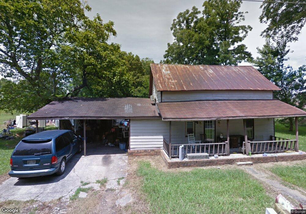
95 Shady Grove Rd Manchester, TN 37355
Estimated Value: $49,084 - $233,000
--
Bed
1
Bath
1,372
Sq Ft
$100/Sq Ft
Est. Value
About This Home
This home is located at 95 Shady Grove Rd, Manchester, TN 37355 and is currently estimated at $137,271, approximately $100 per square foot. 95 Shady Grove Rd is a home located in Coffee County with nearby schools including East Coffee Elementary School, Coffee County Middle School, and Coffee County Central High School.
Ownership History
Date
Name
Owned For
Owner Type
Purchase Details
Closed on
Feb 9, 2006
Sold by
Johnson Rabon and Johnson James
Bought by
Sanders Carl
Current Estimated Value
Purchase Details
Closed on
Nov 1, 1996
Bought by
Raybon Johnson and Cunningham James
Purchase Details
Closed on
Mar 12, 1991
Bought by
Alford Sandy Toni
Purchase Details
Closed on
Aug 24, 1989
Bought by
Alley William E and Alley Barbara
Create a Home Valuation Report for This Property
The Home Valuation Report is an in-depth analysis detailing your home's value as well as a comparison with similar homes in the area
Home Values in the Area
Average Home Value in this Area
Purchase History
| Date | Buyer | Sale Price | Title Company |
|---|---|---|---|
| Sanders Carl | $25,000 | -- | |
| Raybon Johnson | $26,000 | -- | |
| Alford Sandy Toni | $21,500 | -- | |
| Alley William E | $18,000 | -- |
Source: Public Records
Tax History Compared to Growth
Tax History
| Year | Tax Paid | Tax Assessment Tax Assessment Total Assessment is a certain percentage of the fair market value that is determined by local assessors to be the total taxable value of land and additions on the property. | Land | Improvement |
|---|---|---|---|---|
| 2024 | $190 | $8,150 | $2,050 | $6,100 |
| 2023 | $190 | $8,150 | $0 | $0 |
| 2022 | $190 | $8,150 | $2,050 | $6,100 |
| 2021 | $290 | $9,900 | $1,450 | $8,450 |
| 2020 | $290 | $9,900 | $1,450 | $8,450 |
| 2019 | $290 | $9,900 | $1,450 | $8,450 |
| 2018 | $290 | $9,900 | $1,450 | $8,450 |
| 2017 | $269 | $8,250 | $2,100 | $6,150 |
| 2016 | $269 | $8,250 | $2,100 | $6,150 |
| 2015 | $269 | $8,250 | $2,100 | $6,150 |
| 2014 | $269 | $8,234 | $0 | $0 |
Source: Public Records
Map
Nearby Homes
- 2498 Sp Anderson Rd
- 7807 McMinnville Hwy Unit 7807
- 667 Pete Sain Rd
- 0 Ramsey Rd
- 0 Pete Sain Rd
- 300 Willow Brook Dr
- 363 Willow Brook Dr
- 2635 Pete Sain Rd
- 0 Mcafee Rd
- 0 Mcafee E Unit RTC2865293
- 837 Circle Dr
- 670 Old McMinnville Hwy
- 781 Circle Dr
- 1037 Mcafee Rd
- 231 Tom Johnson Rd
- 105 Barbara Spears Rd
- 967 Mud Creek Rd
- 0 Hickerson Rd
- 4282 McMinnville Hwy Unit 4270
- 0 Rock Rd
- 155 Shady Grove Rd
- 61 Shady Grove Rd
- 120 Shady Grove Rd
- 173 Shady Grove Rd
- 60 Shady Grove Rd
- 205 Shady Grove Rd
- 1018 Summitville Rd
- 210 Shady Grove Rd
- 2 Shady Grove Rd
- 1064 Summitville Rd
- 73 Clark Rd
- 900 Summitville Rd
- 957 Summitville Rd
- 913 Summitville Rd
- 11 New Town Loop
- 211 New Town Loop
- 977 Summitville Rd
- 287 Shady Grove Rd
- 1121 Summitville Rd
- 125 Clark Rd