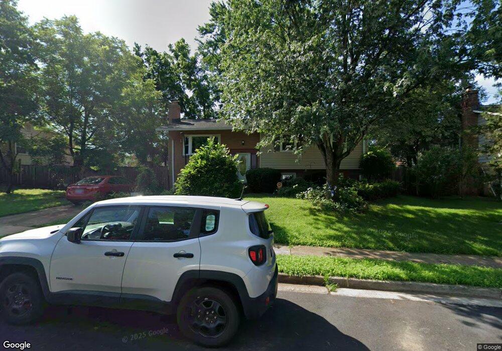
9509 Bonair Dr Manassas, VA 20109
Estimated Value: $503,000 - $561,000
4
Beds
3
Baths
1,205
Sq Ft
$441/Sq Ft
Est. Value
About This Home
This home is located at 9509 Bonair Dr, Manassas, VA 20109 and is currently estimated at $530,861, approximately $440 per square foot. 9509 Bonair Dr is a home located in Prince William County with nearby schools including Sudley Elementary School, Unity Braxton Middle School, and Unity Reed High School.
Ownership History
Date
Name
Owned For
Owner Type
Purchase Details
Closed on
Oct 2, 2025
Sold by
Scott Neal Bernard and Scott Christine Ann
Bought by
Neal And Christine Scott Family Trust and Scott
Current Estimated Value
Purchase Details
Closed on
Jun 26, 1995
Sold by
Assocs Relocation Mgmt Co Inc
Bought by
Burns Robert D
Home Financials for this Owner
Home Financials are based on the most recent Mortgage that was taken out on this home.
Original Mortgage
$139,650
Interest Rate
7.82%
Create a Home Valuation Report for This Property
The Home Valuation Report is an in-depth analysis detailing your home's value as well as a comparison with similar homes in the area
Home Values in the Area
Average Home Value in this Area
Purchase History
| Date | Buyer | Sale Price | Title Company |
|---|---|---|---|
| Neal And Christine Scott Family Trust | -- | None Listed On Document | |
| Burns Robert D | $147,000 | -- | |
| Assocs Relocation Mgmt Co Inc | $145,250 | -- |
Source: Public Records
Mortgage History
| Date | Status | Borrower | Loan Amount |
|---|---|---|---|
| Previous Owner | Assocs Relocation Mgmt Co Inc | $139,650 |
Source: Public Records
Tax History Compared to Growth
Tax History
| Year | Tax Paid | Tax Assessment Tax Assessment Total Assessment is a certain percentage of the fair market value that is determined by local assessors to be the total taxable value of land and additions on the property. | Land | Improvement |
|---|---|---|---|---|
| 2025 | $4,530 | $478,500 | $140,700 | $337,800 |
| 2024 | $4,530 | $455,500 | $129,800 | $325,700 |
| 2023 | $4,539 | $436,200 | $125,000 | $311,200 |
| 2022 | $4,731 | $427,200 | $125,000 | $302,200 |
| 2021 | $4,794 | $391,200 | $113,700 | $277,500 |
| 2020 | $5,642 | $364,000 | $113,700 | $250,300 |
| 2019 | $5,349 | $345,100 | $113,700 | $231,400 |
| 2018 | $4,019 | $332,800 | $113,700 | $219,100 |
| 2017 | $3,955 | $318,700 | $113,700 | $205,000 |
| 2016 | $3,719 | $302,100 | $100,300 | $201,800 |
| 2015 | $3,308 | $294,000 | $96,800 | $197,200 |
| 2014 | $3,308 | $262,000 | $85,500 | $176,500 |
Source: Public Records
Map
Nearby Homes
- 7726 Amherst Dr
- 9613 King George Dr
- 7812 Amherst Dr
- 7703 Amherst Dr
- 9732 Copeland Dr
- 9724 Copeland Dr
- 7723 Appomattox Ave
- 118 Mace St
- 186 Lambert Dr
- 9405 Blackstone Rd
- 7608 Bland Dr
- 7601 Bull Run Rd
- 8333 Gaither St
- 107 Luxor St
- 7530 Campbell Ct
- 319 Moseby Ct Unit E
- 122 Holden Dr
- 8334 Shady Grove Cir
- 7823 Brookview Ct
- 8310 Rolling Rd
- 9511 Bonair Dr
- 9507 Bonair Dr
- 9408 King George Dr
- 9410 King George Dr
- 9513 Bonair Dr
- 9406 King George Dr
- 9505 Bonair Dr
- 9412 King George Dr
- 9508 Bonair Dr
- 9510 Bonair Dr
- 9506 Bonair Dr
- 9414 King George Dr
- 9404 King George Dr
- 9512 Bonair Dr
- 9515 Bonair Dr
- 9504 Bonair Dr
- 9503 Bonair Dr
- 9416 King George Dr
- 9402 King George Dr
- 9514 Bonair Dr