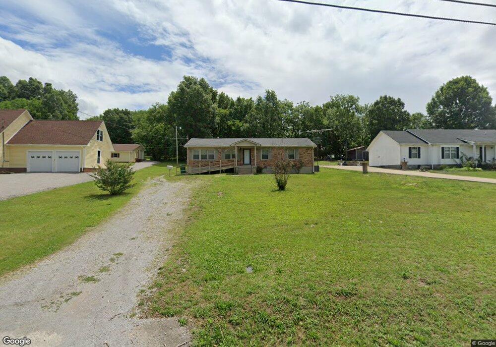
971 Cheryl Dr Lewisburg, TN 37091
Estimated Value: $174,958 - $271,000
--
Bed
1
Bath
1,352
Sq Ft
$173/Sq Ft
Est. Value
About This Home
This home is located at 971 Cheryl Dr, Lewisburg, TN 37091 and is currently estimated at $234,490, approximately $173 per square foot. 971 Cheryl Dr is a home located in Marshall County with nearby schools including Marshall Elementary School, Oak Grove Elementary School, and Westhills Elementary School.
Ownership History
Date
Name
Owned For
Owner Type
Purchase Details
Closed on
Feb 21, 2017
Bought by
Whaley Brian
Current Estimated Value
Home Financials for this Owner
Home Financials are based on the most recent Mortgage that was taken out on this home.
Original Mortgage
$75,650
Outstanding Balance
$62,547
Interest Rate
4.15%
Estimated Equity
$171,943
Create a Home Valuation Report for This Property
The Home Valuation Report is an in-depth analysis detailing your home's value as well as a comparison with similar homes in the area
Home Values in the Area
Average Home Value in this Area
Purchase History
| Date | Buyer | Sale Price | Title Company |
|---|---|---|---|
| Whaley Brian | -- | -- |
Source: Public Records
Mortgage History
| Date | Status | Borrower | Loan Amount |
|---|---|---|---|
| Open | Whaley Brian | $75,650 | |
| Closed | Whaley Brian | -- |
Source: Public Records
Tax History Compared to Growth
Tax History
| Year | Tax Paid | Tax Assessment Tax Assessment Total Assessment is a certain percentage of the fair market value that is determined by local assessors to be the total taxable value of land and additions on the property. | Land | Improvement |
|---|---|---|---|---|
| 2024 | -- | $30,575 | $7,500 | $23,075 |
| 2023 | $949 | $30,575 | $7,500 | $23,075 |
| 2022 | $949 | $30,575 | $7,500 | $23,075 |
| 2021 | $852 | $18,300 | $4,500 | $13,800 |
| 2020 | $897 | $19,275 | $4,500 | $14,775 |
| 2019 | $868 | $19,275 | $4,500 | $14,775 |
| 2018 | $858 | $19,275 | $4,500 | $14,775 |
| 2017 | $858 | $19,275 | $4,500 | $14,775 |
| 2016 | $863 | $16,850 | $4,000 | $12,850 |
| 2015 | $787 | $16,850 | $4,000 | $12,850 |
| 2014 | $787 | $16,850 | $4,000 | $12,850 |
Source: Public Records
Map
Nearby Homes
- 104 Mackenzie Way
- MEDFORD Plan at King's Landing
- 1205 Maelee Ann Dr
- 125 Southview Dr
- 103 Mackenzie Way
- 147 Mackenzie Way
- 198 Southview Dr
- 149 Mackenzie Way
- 151 Mackenzie Way
- 153 Mackenzie Way
- 155 Mackenzie Way
- 157 Mackenzie Way
- 159 Mackenzie Way
- 301 Weston Dr
- 1011 Cornersville Rd
- 1235 Yell Rd
- 185 Southview Dr
- 1128 Moreno Ln
- 313 Pardo Dr
- 1361 Yell Rd