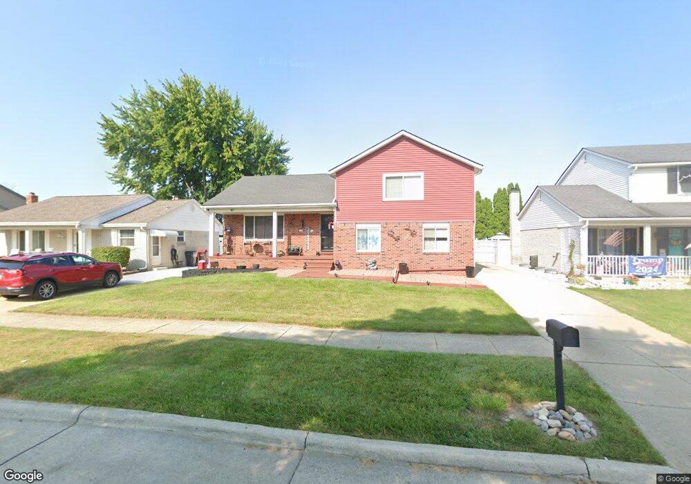
9718 Sharon St Taylor, MI 48180
Estimated Value: $279,948 - $317,000
3
Beds
2
Baths
1,815
Sq Ft
$164/Sq Ft
Est. Value
About This Home
This home is located at 9718 Sharon St, Taylor, MI 48180 and is currently estimated at $298,487, approximately $164 per square foot. 9718 Sharon St is a home located in Wayne County with nearby schools including Holland Elementary School, Hoover Middle School, and Taylor High School.
Ownership History
Date
Name
Owned For
Owner Type
Purchase Details
Closed on
Nov 12, 2015
Sold by
Ellis David and Ellis Renee
Bought by
Ellis Renee
Current Estimated Value
Purchase Details
Closed on
Apr 20, 2011
Sold by
Secretary Of Housing & Urban Development
Bought by
Ellis David and Ellis Renee
Purchase Details
Closed on
Sep 30, 2010
Sold by
Flagstar Bank
Bought by
Secretary Of Housing & Urban Development
Purchase Details
Closed on
Jul 26, 2010
Sold by
Mortgage Electronic Registration Systems
Bought by
Flagstar Bank
Purchase Details
Closed on
Jul 14, 2010
Sold by
Hudson Phillip K and Hudson Jacqueline A
Bought by
Mortgage Electronic Registration Systems
Purchase Details
Closed on
Apr 6, 2001
Sold by
Fragassi John C
Bought by
Hudson Jacqueline A
Create a Home Valuation Report for This Property
The Home Valuation Report is an in-depth analysis detailing your home's value as well as a comparison with similar homes in the area
Home Values in the Area
Average Home Value in this Area
Purchase History
| Date | Buyer | Sale Price | Title Company |
|---|---|---|---|
| Ellis Renee | -- | Attorney | |
| Ellis David | $90,129 | None Available | |
| Secretary Of Housing & Urban Development | -- | None Available | |
| Flagstar Bank | -- | None Available | |
| Mortgage Electronic Registration Systems | $214,303 | None Available | |
| Hudson Jacqueline A | $158,000 | -- |
Source: Public Records
Mortgage History
| Date | Status | Borrower | Loan Amount |
|---|---|---|---|
| Closed | Hudson Jacqueline A | -- |
Source: Public Records
Tax History Compared to Growth
Tax History
| Year | Tax Paid | Tax Assessment Tax Assessment Total Assessment is a certain percentage of the fair market value that is determined by local assessors to be the total taxable value of land and additions on the property. | Land | Improvement |
|---|---|---|---|---|
| 2025 | $2,464 | $130,300 | $0 | $0 |
| 2024 | $2,464 | $110,000 | $0 | $0 |
| 2023 | $2,351 | $99,400 | $0 | $0 |
| 2022 | $2,351 | $89,700 | $0 | $0 |
| 2021 | $2,643 | $83,100 | $0 | $0 |
| 2020 | $2,618 | $76,800 | $0 | $0 |
| 2019 | $261,733 | $72,700 | $0 | $0 |
| 2018 | $2,019 | $67,300 | $0 | $0 |
| 2017 | $1,224 | $64,200 | $0 | $0 |
| 2016 | $2,559 | $62,300 | $0 | $0 |
| 2015 | $4,562 | $51,800 | $0 | $0 |
| 2013 | $4,550 | $46,400 | $0 | $0 |
| 2012 | $2,000 | $46,000 | $15,300 | $30,700 |
Source: Public Records
Map
Nearby Homes
- 9786 Princess St
- 9915 Beech Daly Rd
- 9404 Princess St
- 9756 Janet St
- 10051 Fairview St
- 25315 Baker St
- 25737 Rusty St
- 25341 Kinyon St
- 0 Goddard Unit 20251010304
- 8883 Beech Daly Rd
- 10053 Michael St
- 8853 Beech Daly Rd
- 11081 Coventry Ct Unit 31
- 11098 Partridge Dr Unit 12
- 11098 Partridge Dr
- 10057 Westlake St
- Bayberry Plan at Cypress Garden
- Bannister Plan at Cypress Garden
- Cypress Plan at Cypress Garden
- Evanston IV Plan at Cypress Garden