
Seller's Agent in 2025
Brad Garrison
Whitetail Properties Real Estate
(317) 701-8655
58 Total Sales

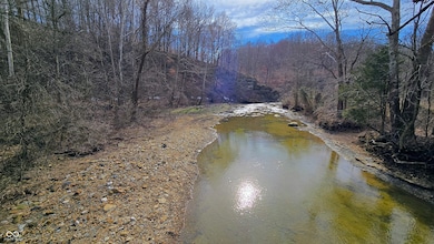
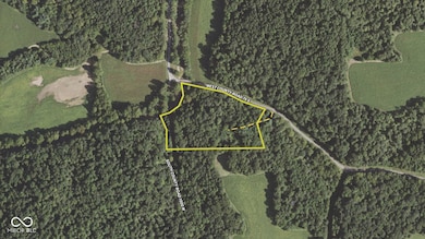

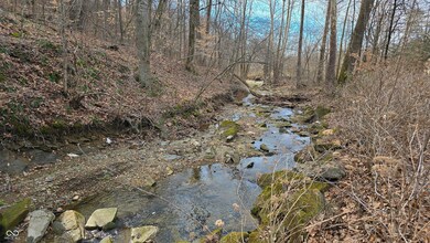
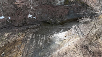
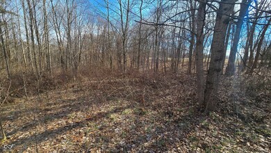
NEW* The 2.16 +- ac. tract next to this parcel is now for sale also! This hilltop property offers a unique opportunity with stunning features such as a rock cliff, mature timber, and convenient proximity to a US highway. It boasts over 750 feet +- of paved road frontage along W County Road 75 S, plus an additional 300 feet +- along 1000 West, an unmaintained county road. The property also has a deeded easement for vehicle access on the east side, providing multiple entry points for new owners. It overlooks Guthrie Creek and offers ample space and mature timber perfect for hunting, camping, hiking, birdwatching, or building a new home. The land has been used for hunting in recent years, with mature bucks harvested in 2023 and 2024. There is several big rubs and the bluff would make an obvious pinch point presuming the deer have to move east and west across the property. At the top of the hill, there's an overgrown clearing where the previous owner once had a camper with electricity and satellite cable. This property would also make a great campground for those who love to ride offroad vehicles and have street legal SXS's. Located less than a mile from US 50, travel to both the east and west is simple. The property is only 15 minutes from Brownstown and less than 30 minutes from Seymour and Bedford, offering easy access to shopping and dining. The Indianapolis 465 loop and Louisville are both just over 1 hour away making this a good option for weekend retreat from the city. The Jackson County area is home to numerous public hunting areas, including Hoosier National Forest, Austin Bottoms, Jackson-Washington Forest, and nearby Lake Monroe to the northwest. For family outings, nearby attractions include Muscatatuck National Wildlife Refuge, Starve Hollow SRA, and Cave River Valley Nature Area.
Last Agent to Sell the Property
Whitetail Properties License #RB23000368 Listed on: 02/05/2025
Property Type
Est. Annual Taxes
Lot Details
Property Views
Schools
Utilities
Listing and Financial Details
Overview
Recreation
| Date | Type | Sale Price | Title Company |
|---|---|---|---|
| Quit Claim Deed | $8,000 | -- | |
| Warranty Deed | $1,080 | Bevers Susan D |
| Date | Event | Price | Change | Sq Ft Price |
|---|---|---|---|---|
| 07/11/2025 07/11/25 | Sold | $62,500 | -10.7% | -- |
| 06/17/2025 06/17/25 | Pending | -- | -- | -- |
| 05/23/2025 05/23/25 | Price Changed | $70,000 | +133.3% | -- |
| 03/12/2025 03/12/25 | For Sale | $30,000 | -62.5% | -- |
| 02/05/2025 02/05/25 | For Sale | $80,000 | -- | -- |
| Year | Tax Paid | Tax Assessment Tax Assessment Total Assessment is a certain percentage of the fair market value that is determined by local assessors to be the total taxable value of land and additions on the property. | Land | Improvement |
|---|---|---|---|---|
| 2024 | $228 | $13,800 | $12,300 | $1,500 |
| 2023 | $237 | $13,800 | $12,300 | $1,500 |
| 2022 | $235 | $13,800 | $12,300 | $1,500 |
| 2021 | $235 | $13,600 | $12,300 | $1,300 |
| 2020 | $235 | $13,700 | $12,300 | $1,400 |
| 2019 | $223 | $13,700 | $12,300 | $1,400 |
| 2018 | $216 | $13,700 | $12,300 | $1,400 |
| 2017 | $210 | $14,100 | $12,300 | $1,800 |
| 2016 | $205 | $13,300 | $12,300 | $1,000 |
| 2014 | $353 | $22,500 | $12,300 | $10,200 |
| 2013 | $353 | $4,300 | $4,300 | $0 |
Seller's Agent in 2025
Brad Garrison
Whitetail Properties Real Estate
(317) 701-8655
58 Total Sales
Source: MIBOR Broker Listing Cooperative®
MLS Number: 22021028
APN: 36-53-17-300-016.001-010
Disclaimer: Certain information contained herein is derived from information provided by parties other than Homes.com. All information provided is deemed reliable, but is not guaranteed to be accurate and should be independently verified.
![]() Based on information submitted to the MLS GRID. All data is obtained from various sources and may not have been verified by broker or MLS GRID. Supplied Open House Information is subject to change without notice. All information should be independently reviewed and verified for accuracy. Properties may or may not be listed by the office/agent presenting the information. Some IDX listings have been excluded from this website.
Based on information submitted to the MLS GRID. All data is obtained from various sources and may not have been verified by broker or MLS GRID. Supplied Open House Information is subject to change without notice. All information should be independently reviewed and verified for accuracy. Properties may or may not be listed by the office/agent presenting the information. Some IDX listings have been excluded from this website.