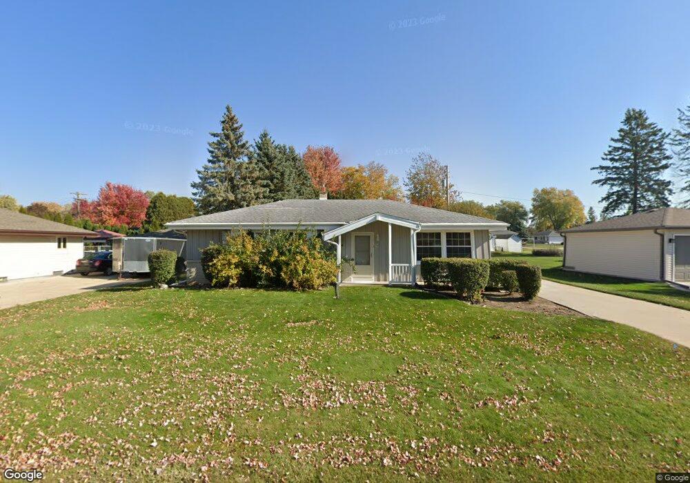
W242N6578 Locust St Sussex, WI 53089
Estimated Value: $361,000 - $420,000
3
Beds
2
Baths
1,196
Sq Ft
$319/Sq Ft
Est. Value
About This Home
This home is located at W242N6578 Locust St, Sussex, WI 53089 and is currently estimated at $381,589, approximately $319 per square foot. W242N6578 Locust St is a home located in Waukesha County with nearby schools including Maple Avenue Elementary School, Templeton Middle School, and Hamilton High School.
Ownership History
Date
Name
Owned For
Owner Type
Purchase Details
Closed on
Sep 9, 2016
Sold by
Robles Christy A
Bought by
Kiel Howard H
Current Estimated Value
Purchase Details
Closed on
Apr 28, 2000
Sold by
Fonder Marvin and Fonder Marion
Bought by
Robles Christy A
Home Financials for this Owner
Home Financials are based on the most recent Mortgage that was taken out on this home.
Original Mortgage
$117,000
Interest Rate
7.87%
Mortgage Type
Purchase Money Mortgage
Create a Home Valuation Report for This Property
The Home Valuation Report is an in-depth analysis detailing your home's value as well as a comparison with similar homes in the area
Home Values in the Area
Average Home Value in this Area
Purchase History
| Date | Buyer | Sale Price | Title Company |
|---|---|---|---|
| Kiel Howard H | $215,500 | None Available | |
| Robles Christy A | $130,000 | -- |
Source: Public Records
Mortgage History
| Date | Status | Borrower | Loan Amount |
|---|---|---|---|
| Previous Owner | Robles Christy A | $117,000 |
Source: Public Records
Tax History Compared to Growth
Tax History
| Year | Tax Paid | Tax Assessment Tax Assessment Total Assessment is a certain percentage of the fair market value that is determined by local assessors to be the total taxable value of land and additions on the property. | Land | Improvement |
|---|---|---|---|---|
| 2024 | $3,829 | $318,100 | $83,000 | $235,100 |
| 2023 | $4,015 | $325,700 | $83,000 | $242,700 |
| 2022 | $3,766 | $272,400 | $72,000 | $200,400 |
| 2021 | $3,347 | $240,000 | $60,000 | $180,000 |
| 2020 | $3,434 | $230,000 | $60,000 | $170,000 |
| 2019 | $3,289 | $213,500 | $52,500 | $161,000 |
| 2018 | $3,150 | $207,200 | $46,200 | $161,000 |
| 2017 | $3,097 | $206,900 | $46,200 | $160,700 |
| 2016 | $2,806 | $182,100 | $46,200 | $135,900 |
| 2015 | $2,860 | $182,100 | $46,200 | $135,900 |
| 2014 | $2,681 | $174,200 | $46,200 | $128,000 |
| 2013 | $2,681 | $165,400 | $46,200 | $119,200 |
Source: Public Records
Map
Nearby Homes
- Lt0 Maple Ave
- N63W23954 Terrace Dr
- N63w23524 Silver Spring Dr
- N71W24818 Wildwood Way
- W238N7214 Michele Ln
- W247N5929 Grouse Ct
- W233N6997 Salem Dr
- W247N7543 Overland Rd
- W253N6628 Heavenly Ct
- W253N6563 Heavenly Ct
- N66W25720 Big Sky Dr
- N67W25396 Vail Ln
- N67W25502 Vail Ln
- W243N7650 Hilltop Ct
- N55W23842 Fieldstone Pass Cir
- N67W25606 Vail Ln
- W242N5607 Simona Ct
- The Lily Plan at Vista Run
- The Clare Plan at Vista Run
- The Savannah Plan at Vista Run
- W242N6592 Locust St
- W242N6577 Locust St
- N65W24260 Poplar Ave
- W242N6565 Locust St
- W242N6591 Locust St
- W242N6577 Spruce St
- W242N6604 Locust St
- W242N6565 Spruce St
- W242N6601 Locust St
- N65W24233 Poplar Ave
- W242N6551 Locust St
- W242N6591 Spruce St
- W242N6603 Spruce St
- N65W24217 Poplar Ave
- W242N6616 Locust St
- W243N6576 Westhaven Dr
- N65W24201 Poplar Ave
- W243N6588 Westhaven Dr
- W242N6613 Locust St
- W242N6615 Spruce St