


0 S Hwy 101 Depoebay, OR 97341
Estimated payment $4,350/month
Highlights
- Ocean View
- Wooded Lot
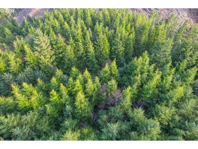
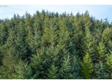
- Timber
- 36.27 Acre Lot
- No HOA
- No Heating
About This Lot
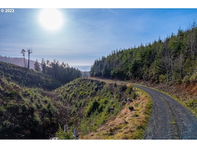
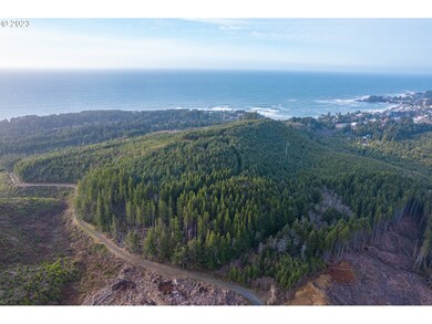
Ocean mists float over this terrain, as acres of trees grow steadily. Featuring a main stand of 21 acres of 29 year old Doug Fir, this parcel is smaller, but diversified, and includes 7 acres of 16 year old Hemlock, and 8.7 acres of 48 year old Hemlock. Surrounded by producing timberland with a recently logged neighboring parcel. Ranging from about 250-450 feet elevation, it includes its own hill for impressive ocean views. Legal access to parcel TBD. Zoned TC.Potential pathways to buildability per. Lincoln Co. Zoning ordinance (property to qualify)
Property Details
Property Type
- Land
Est. Annual Taxes
- $252
Lot Details
- 36.27 Acre Lot
- Sloped Lot
- Wooded Lot
- Property is zoned TC
Property Views
- Ocean
- Woods
- Territorial
Schools
- Taft Elementary And Middle School
- Taft High School
Additional Features
- Timber
- No Utilities
Community Details
- No Home Owners Association
Listing and Financial Details
- Assessor Parcel Number R334443
Map
Tax History
We collect this data history from publicly available records. To have your information removed, we recommend requesting removal directly through your county’s website.
| Year | Tax Paid | Tax Assessment Tax Assessment Total Assessment is a certain percentage of the fair market value that is determined by local assessors to be the total taxable value of land and additions on the property. | Land | Improvement |
|---|---|---|---|---|
| 2025 | $273 | $20,770 | $20,770 | -- |
| 2024 | $283 | $20,160 | $20,160 | -- |
| 2023 | $270 | $19,580 | $0 | $0 |
| 2022 | $252 | $19,010 | $0 | $0 |
| 2021 | $246 | $18,450 | $0 | $0 |
| 2020 | $240 | $17,920 | $0 | $0 |
| 2019 | $231 | $17,390 | $0 | $0 |
| 2018 | $226 | $16,890 | $0 | $0 |
| 2017 | $221 | $16,400 | $0 | $0 |
| 2016 | $209 | $15,450 | $0 | $0 |
| 2015 | $192 | $15,450 | $0 | $0 |
| 2014 | $188 | $15,000 | $0 | $0 |
| 2013 | -- | $14,570 | $0 | $0 |
Property History
We collect this data history from publicly available records. To have your information removed, we recommend requesting removal directly through your county’s website.
| Date | Event | Price | List to Sale | Price per Sq Ft |
|---|---|---|---|---|
| 01/30/2026 01/30/26 | Price Changed | $799,000 | +3.9% | -- |
| 08/21/2025 08/21/25 | Price Changed | $769,000 | -6.1% | -- |
| 03/26/2025 03/26/25 | Price Changed | $819,000 | +17.2% | -- |
| 08/01/2024 08/01/24 | Price Changed | $699,000 | -6.7% | -- |
| 01/23/2024 01/23/24 | Price Changed | $749,000 | -3.9% | -- |
| 08/08/2023 08/08/23 | Price Changed | $779,000 | -2.5% | -- |
| 03/09/2023 03/09/23 | For Sale | $799,000 | -- | -- |
Source: Regional Multiple Listing Service (RMLS)
MLS Number: 23697413
APN: R334443
Disclaimer: Certain information contained herein is derived from information provided by parties other than Homes.com. All information provided is deemed reliable, but is not guaranteed to be accurate and should be independently verified.
![]() The content relating to real estate for sale on this web site comes in part from the IDX program of the RMLS™ of Portland, Oregon. Real estate listings held by brokerage firms other than Ten-X are marked with the RMLS™ logo, and detailed information about these properties includes the names of the listing brokers. Listing content is copyright © 2026 RMLS™, Portland, Oregon. Some properties which appear for sale on this web site may subsequently have sold or may no longer be available. All information provided is deemed reliable but is not guaranteed and should be independently verified.
The content relating to real estate for sale on this web site comes in part from the IDX program of the RMLS™ of Portland, Oregon. Real estate listings held by brokerage firms other than Ten-X are marked with the RMLS™ logo, and detailed information about these properties includes the names of the listing brokers. Listing content is copyright © 2026 RMLS™, Portland, Oregon. Some properties which appear for sale on this web site may subsequently have sold or may no longer be available. All information provided is deemed reliable but is not guaranteed and should be independently verified.
- 0 S Hwy 101 Unit Lot 500
- 0 S Hwy 101 Unit Lot 600
- TL 600 S Highway 101
- TL 500 S Highway 101
- 0 S Highway 101 Unit 802597
- 95 SW Cormorant
- 180 Gull Station
- Lot 180 Gull Station
- 335 SW South Point St
- 140 SW Gull Station
- 199 SW The Pines Dr
- 215 Nesting Glade
- 1470 SW Tintinnabulary Place
- 170 SW Cormorant
- TL 3900 SW Coast Ave
- 735 SE Indian Trail Ave
- 665 SE Indian Trail Ave
- 0 Cliff St Unit Lot 9
- 9 Cliff St
- 1845 SW McDonald Ave
- 175 The Pines
- 442 SW Coast Ave Unit 442
- 3440 S Hwy 101
- 425 Siletz Ave
- 2050 Us-101 Unit 2
- 2050 Us-101 Unit 28
- 3440 Us-101
- 3605 Sea Mist Ave
- 40 Fern St
- 5188 S Summer Place
- 1977 S Windy Bend Dr
- 227 NW 55th St
- 4510 SW Coast Ave
- 529 SW 32nd St
- 537 SW 32nd St
- 708 NE Avery St Unit 1041/A/G
- 127 NE Benton St
- 1220 SE Oar Ave
- 1000 SW Bay St Unit G348
- 1000 SW Bay St Unit i420

Ask me questions while you tour the home.