
Seller's Agent in 2024
Bob Acheson
Zimmerman Realty, Ltd.
(937) 539-2148
25 Total Sales
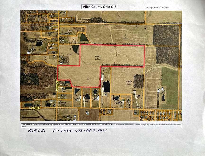

$11,000 per acre48.58 acres total. 47.58 tillable.ZC - CropGNB - GLYNWOOD SILT LOAM 2-6% SLOPES2.60$730$1,900ZC - CropGRB2 - GLYNWOOD SILTY CLAY LOAM 2-6%8.55$350$2,990ZC - CropPMA - PEWAMO SILTY CLAY LOAM 0-1% SL9.87$2,240$22,110ZC - CropBOB - BLOUNT SILT LOAM 2 TO 6% SLOPES31.15$1,270$39,560ZC - CropGRC2 - GLYNWOOD SILTY CLAY LOAM 6-12%1.15$350$400ZO - OtherBOB - BLOUNT SILT LOAM 2 TO 6% SLOPES0.21$0$0ZO - OtherGRC2 - GLYNWOOD SILTY CLAY LOAM 6-12%0.11$0$0
Last Agent to Sell the Property
Zimmerman Realty, Ltd. License #0000238967 Listed on: 05/12/2022
| Date | Event | Price | List to Sale | Price per Sq Ft |
|---|---|---|---|---|
| 10/08/2024 10/08/24 | Sold | $486,600 | -8.9% | -- |
| 05/13/2024 05/13/24 | For Sale | $534,380 | +9.8% | -- |
| 05/11/2024 05/11/24 | Off Market | $486,600 | -- | -- |
| 08/01/2023 08/01/23 | Price Changed | $534,380 | -12.0% | -- |
| 05/12/2022 05/12/22 | For Sale | $607,250 | -- | -- |
Seller's Agent in 2024
Bob Acheson
Zimmerman Realty, Ltd.
(937) 539-2148
25 Total Sales
Source: Western Regional Information Systems & Technology (WRIST)
MLS Number: 1020732
Disclaimer: Certain information contained herein is derived from information provided by parties other than Homes.com. All information provided is deemed reliable, but is not guaranteed to be accurate and should be independently verified.
![]() IDX information is provided exclusively for personal, non-commercial use, and may not be used for any purpose other than to identify prospective properties consumers may be interested in purchasing.
IDX information is provided exclusively for personal, non-commercial use, and may not be used for any purpose other than to identify prospective properties consumers may be interested in purchasing.
Ask me questions while you tour the home.