NOT LISTED FOR SALE

000 King Rd Thompsonville, MI 49683

240 Acres
-- Price per Acre
10,454,400 Sq Ft Lot

Last Sold December 17, 2014

Last sale price $625,000

712 Days on Market

Highlights

  • Private Waterfront
  • Home fronts a creek
  • Countryside Views
  • Deeded Waterfront Access Rights
  • 240 Acre Lot
  • Adjoins Government Land

About This Lot

As of December 2014

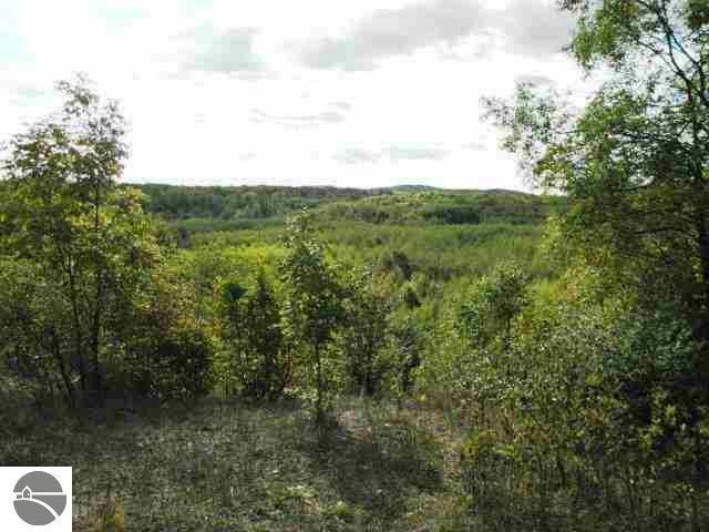
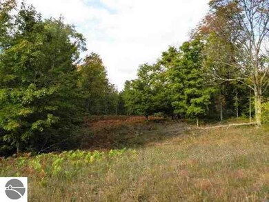
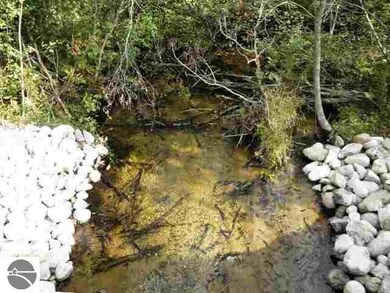
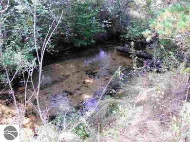
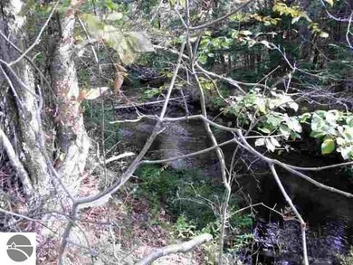
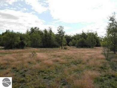
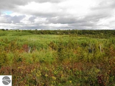
240 acres - beautiful wild country. Complete with 1/2 mile of Dair Creek running thru. Dair Creek runs into the Betsie River and is part of the Wild Rivers Act. Deer for the hunters and Trout for the fisherman. Variety of landscapes - hilly, level, wooded, meadow, creekside. Property runs from King Rd all the way to Landis Rd. Surrounded by State Land. Perfect for privacy. Near Crystal Mountain and the Betsie River.

Last Agent to Sell the Property

Carol Dye

Dye Real Estate License #6504202249 Listed on: 10/11/2012

Last Buyer's Agent

Carol Dye

Dye Real Estate License #6504202249 Listed on: 10/11/2012

Property Details

Property Type

  • Land

Lot Details

  • 240 Acre Lot
  • Home fronts a creek
  • Private Waterfront
  • 2,600 Feet of Waterfront
  • Adjoins Government Land
  • Level Lot
  • The community has rules related to zoning restrictions

Utilities

  • Well
  • Private or Community Septic Tank

Additional Features

  • Countryside Views
  • Deeded Waterfront Access Rights

Property Details

Property Type

Land

Lot Details

0

Listing Details

  • Class: Vacant Lot/Land
  • Type: Vacant Lot/Land
  • Private Shared: Private
  • Section Number: 20
  • Special Features: None
  • Property Sub Type: LotsLands

Interior Features

  • Price Per Sq Ft: 2604.17
  • Range: R 14W

Exterior Features

  • Body Of Water: Dair Creek
  • Exterior Features: Countryside View
  • Number Of Acres: 240
  • Road: Public Maintained, Gravel
  • Water Features: Priv Frontage (Wtr Side), Creek
  • Waterfront Frontage: 2600

Utilities

  • Utilities Available: Electric
  • Waste Available: Private Septic
  • Water Available: Private Well

Schools

  • School District: Benzie County Central Schools

Lot Info

  • Deeded Waterfront: Yes
  • Land Features: Level, Rolling, Hardwoods, Joins State/Federal Land
  • Lot Dimensions: 1320x1320+2640x2640
  • Mineral Rights: Unknown
  • Zoning Use Restrictions: Residential, Forest/Recreational, Horses Allowed, Splits Available

Tax Info

  • Taxable Value: 69629

MLS Schools

  • School District: Benzie County Central Schools

Range of Values:

Collateral Analytics

Collateral Analytics Collateral Analytics AVMs (Automated Valuation Model) employ a number of statistical approaches combined with neighborhood-specific comparable selection guarantees the most up-to-date and precise valuations.

Not Available

Collateral Analytics does not have data for the current month. Please view the chart for historical values.

ICE

ICE Mortgage Technology ICE Mortgage Technology’s AVM (Automated Valuation Model) is a state-of-the-art online residential property valuation tool that provides a quick and accurate estimate of the value of almost any home in the U.S.

Not Available

ICE Mortgage Technology does not have data for the current month. Please view the chart for historical values.

First American

First American First American Data & Analytics’ next-generation AVM combines unrivaled data assets with a blended ensemble of valuation models to produce highly accurate, reliable valuations you can trust.

Not Available

First American does not have data for the current month. Please view the chart for historical values.

Quantarium

Quantarium Quantarium’s valuation service, repeatedly proven the industry’s most accurate and comprehensive, is supercharged with a self-learning and auto-tuning AI engine that continually becomes smarter and more accurate as it processes daily inputs from the industry’s leading RE data lake.

Not Available

Quantarium does not have data for the current month. Please view the chart for historical values.

Average Value
Not Available
List Price
Sold Price
Create a Home Valuation Report for This Property
The Home Valuation Report is an in-depth analysis detailing your home's value as well as a comparison with similar homes in the area

Home Values in the Area

Source: Public Records

Average Home Value in this Area


Source: Public Records

Property History

Date Event Price Change Sq Ft Price
12/17/2014 12/17/14 Sold $625,000 -3.7% --
09/23/2014 09/23/14 Pending -- -- --
10/11/2012 10/11/12 For Sale $649,000 -- --
Source: Northern Great Lakes REALTORS® MLS

Tax History Compared to Growth

Source: Public Records

Agents Affiliated with this Home

  • Section Image
See All Agents

Map

Source: Northern Great Lakes REALTORS® MLS

MLS Number: 1740141

Northern Great Lakes REALTORS® MLS