
Seller's Agent in 2025
Cathy Sousa
Serhant New England
(401) 474-8306
6 in this area
140 Total Sales


Estimated Value: $694,000 - $777,000
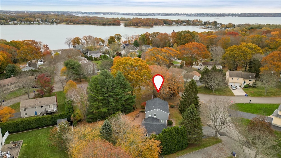
Welcome to 1 Betsy Drive a beautiful 3 bed, 2.5 bath Colonial featuring major recent upgrades including brand new siding, a brand new roof, and a brand new central air system for true peace of mind. The first floor offers a spacious eat-in kitchen that opens to a comfortable family room with a cozy fireplace, along with a separate living room and a formal dining room ideal for hosting, entertaining, or spreading out with multiple living spaces. There is also a generous mudroom directly off the garage perfect for daily drop zone storage, coats, sports gear, etc. Upstairs you'll find a large primary suite with private full bath, plus two additional bedrooms, another full bath, and convenient second-floor laundry. Need more space? The basement is finished providing a terrific bonus area for a playroom, media room, gym, office, or whatever fits your lifestyle. This well-maintained Colonial checks the boxes with modern systems, classic layout, and flexible living space throughout. Ready for its next chapter!
Last Agent to Sell the Property
Serhant New England License #RES.0040311 Listed on: 11/07/2025
We collect this data history from publicly available records. To have your information removed, we recommend requesting removal directly through your county’s website.
| Date | Buyer | Sale Price | Title Company |
|---|---|---|---|
| Petersen Lindsey | $685,000 | -- | |
| Leger Susan | -- | -- | |
| Leger Jaime | $214,000 | -- | |
| Crilly Joseph | $213,000 | -- | |
| Gordon Sharon | $163,000 | -- | |
| Gordon Sharon K | $163,000 | -- |
We collect this data history from publicly available records. To have your information removed, we recommend requesting removal directly through your county’s website.
| Date | Status | Borrower | Loan Amount |
|---|---|---|---|
| Open | Petersen Lindsey | $616,500 | |
| Previous Owner | Gordon Sharon K | $136,000 | |
| Previous Owner | Gordon Sharon K | $139,000 | |
| Previous Owner | Gordon Sharon K | $180,340 |
| Date | Event | Price | List to Sale | Price per Sq Ft |
|---|---|---|---|---|
| 12/30/2025 12/30/25 | Sold | $685,000 | -1.4% | $303 / Sq Ft |
| 12/07/2025 12/07/25 | Pending | -- | -- | -- |
| 11/07/2025 11/07/25 | For Sale | $695,000 | -- | $308 / Sq Ft |
| Year | Tax Paid | Tax Assessment Tax Assessment Total Assessment is a certain percentage of the fair market value that is determined by local assessors to be the total taxable value of land and additions on the property. | Land | Improvement |
|---|---|---|---|---|
| 2025 | $6,530 | $615,500 | $219,600 | $395,900 |
| 2024 | $6,200 | $448,600 | $183,000 | $265,600 |
| 2023 | $5,993 | $448,600 | $183,000 | $265,600 |
| 2022 | $5,832 | $448,600 | $183,000 | $265,600 |
| 2021 | $5,949 | $413,700 | $186,100 | $227,600 |
| 2020 | $5,821 | $413,700 | $186,100 | $227,600 |
| 2019 | $5,676 | $413,700 | $186,100 | $227,600 |
| 2018 | $6,101 | $396,700 | $170,200 | $226,500 |
| 2017 | $5,312 | $356,000 | $150,600 | $205,400 |
| 2016 | $5,258 | $356,000 | $150,600 | $205,400 |
| 2015 | $4,995 | $356,000 | $150,600 | $205,400 |
| 2014 | $5,166 | $395,570 | $172,300 | $223,270 |
Seller's Agent in 2025
Cathy Sousa
Serhant New England
(401) 474-8306
6 in this area
140 Total Sales
Buyer's Agent in 2025
Sonia Amaral
Coldwell Banker Realty
(508) 725-7034
1 in this area
54 Total Sales
Source: State-Wide MLS
MLS Number: 1399356
APN: BRIS-000127-000000-000105
Disclaimer: Certain information contained herein is derived from information provided by parties other than Homes.com. All information provided is deemed reliable, but is not guaranteed to be accurate and should be independently verified.
![]() IDX information is provided exclusively for personal, non-commercial use, and may not be used for any purpose other than to identify prospective properties consumers may be interested in purchasing. Information is deemed reliable but not guaranteed.
IDX information is provided exclusively for personal, non-commercial use, and may not be used for any purpose other than to identify prospective properties consumers may be interested in purchasing. Information is deemed reliable but not guaranteed.
Copyright © 2026 State-Wide MLS, Inc. All rights reserved.
Ask me questions while you tour the home.