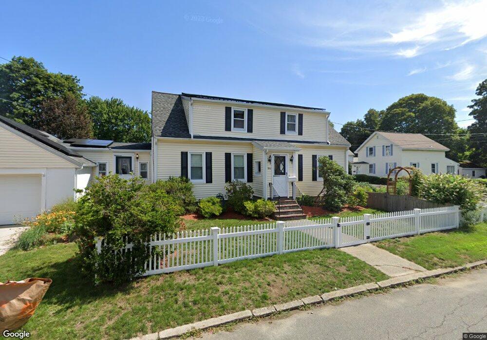
1 Brooks St Woburn, MA 01801
Downtown Woburn NeighborhoodEstimated Value: $662,000 - $784,000
4
Beds
1
Bath
1,681
Sq Ft
$430/Sq Ft
Est. Value
About This Home
This home is located at 1 Brooks St, Woburn, MA 01801 and is currently estimated at $722,827, approximately $429 per square foot. 1 Brooks St is a home located in Middlesex County with nearby schools including Goodyear Elementary School, Daniel L. Joyce Middle School, and Woburn High School.
Ownership History
Date
Name
Owned For
Owner Type
Purchase Details
Closed on
Apr 4, 2023
Sold by
Maiocco Leslie J
Bought by
Leslie J Maiocco T J and Leslie Maiocco
Current Estimated Value
Purchase Details
Closed on
Aug 27, 1999
Sold by
Wright Arthur E and Wright Karen E
Bought by
Maiocco Leslie J
Home Financials for this Owner
Home Financials are based on the most recent Mortgage that was taken out on this home.
Original Mortgage
$139,200
Interest Rate
7.53%
Mortgage Type
Purchase Money Mortgage
Purchase Details
Closed on
May 19, 1988
Sold by
Sarsfield Marie E
Bought by
Cialdea Karen
Home Financials for this Owner
Home Financials are based on the most recent Mortgage that was taken out on this home.
Original Mortgage
$118,000
Interest Rate
10.13%
Mortgage Type
Purchase Money Mortgage
Create a Home Valuation Report for This Property
The Home Valuation Report is an in-depth analysis detailing your home's value as well as a comparison with similar homes in the area
Home Values in the Area
Average Home Value in this Area
Purchase History
| Date | Buyer | Sale Price | Title Company |
|---|---|---|---|
| Leslie J Maiocco T J | -- | None Available | |
| Leslie J Maiocco T | -- | None Available | |
| Maiocco Leslie J | $174,000 | -- | |
| Cialdea Karen | $147,500 | -- |
Source: Public Records
Mortgage History
| Date | Status | Borrower | Loan Amount |
|---|---|---|---|
| Previous Owner | Cialdea Karen | $139,200 | |
| Previous Owner | Cialdea Karen | $118,000 |
Source: Public Records
Tax History
| Year | Tax Paid | Tax Assessment Tax Assessment Total Assessment is a certain percentage of the fair market value that is determined by local assessors to be the total taxable value of land and additions on the property. | Land | Improvement |
|---|---|---|---|---|
| 2025 | $5,004 | $585,900 | $270,800 | $315,100 |
| 2024 | $4,492 | $557,300 | $257,900 | $299,400 |
| 2023 | $4,395 | $505,200 | $234,500 | $270,700 |
| 2022 | $4,272 | $457,400 | $203,900 | $253,500 |
| 2021 | $6,232 | $430,500 | $194,200 | $236,300 |
| 2020 | $3,799 | $407,600 | $194,200 | $213,400 |
| 2019 | $50,800 | $401,600 | $184,900 | $216,700 |
| 2018 | $3,718 | $375,900 | $169,600 | $206,300 |
| 2017 | $5,312 | $348,300 | $161,600 | $186,700 |
| 2016 | $3,303 | $328,700 | $151,000 | $177,700 |
| 2015 | $3,180 | $312,700 | $141,100 | $171,600 |
| 2014 | $2,855 | $273,500 | $141,100 | $132,400 |
Source: Public Records
Map
Nearby Homes
- 18-20 Buck St Unit 1
- 2 Maria Ct
- 38 Pickering St Unit A
- 40 Pickering St
- 380 Cross St
- 0 Mount Pleasant St
- 6 Highland St
- 29 Arlington Rd Unit 3-2
- 29 Arlington Rd Unit 1-1
- 29 Arlington Rd Unit 5
- 27 Arlington Rd Unit 2
- 31 Arlington Rd Unit 1-6
- 3 Golden Terrace
- 149 Horn Pond Brook Rd
- 198 Pond St
- 7 Prospect St
- 52 Pleasant St
- 20 Charles Rd
- 76 Woodside Rd
- 35 Montvale Ave Unit 8
Your Personal Tour Guide
Ask me questions while you tour the home.