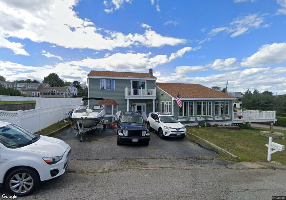
1 Bunker Hill Rd Ipswich, MA 01938
Estimated Value: $1,055,301 - $1,147,000
2
Beds
2
Baths
2,750
Sq Ft
$403/Sq Ft
Est. Value
About This Home
This home is located at 1 Bunker Hill Rd, Ipswich, MA 01938 and is currently estimated at $1,109,325, approximately $403 per square foot. 1 Bunker Hill Rd is a home located in Essex County with nearby schools including Ipswich High School.
Ownership History
Date
Name
Owned For
Owner Type
Purchase Details
Closed on
Oct 17, 2008
Sold by
Lennon Joanne M and Lennon Ronald F
Bought by
Hill Robert D
Current Estimated Value
Purchase Details
Closed on
Aug 23, 2007
Sold by
Castonguay Rebecca and Castonguay Shawn
Bought by
Lennon Ronald F and Lennon Joanne M
Purchase Details
Closed on
Feb 24, 2003
Sold by
Black Dean C
Bought by
Castonguay Shawn and Castonguay Rebecca
Create a Home Valuation Report for This Property
The Home Valuation Report is an in-depth analysis detailing your home's value as well as a comparison with similar homes in the area
Home Values in the Area
Average Home Value in this Area
Purchase History
| Date | Buyer | Sale Price | Title Company |
|---|---|---|---|
| Hill Robert D | $110,000 | -- | |
| Hill Robert D | $110,000 | -- | |
| Lennon Ronald F | $477,000 | -- | |
| Lennon Ronald F | $477,000 | -- | |
| Castonguay Shawn | $415,000 | -- | |
| Castonguay Shawn | $415,000 | -- |
Source: Public Records
Mortgage History
| Date | Status | Borrower | Loan Amount |
|---|---|---|---|
| Open | Castonguay Shawn | $206,000 |
Source: Public Records
Tax History
| Year | Tax Paid | Tax Assessment Tax Assessment Total Assessment is a certain percentage of the fair market value that is determined by local assessors to be the total taxable value of land and additions on the property. | Land | Improvement |
|---|---|---|---|---|
| 2025 | $11,283 | $1,011,900 | $563,300 | $448,600 |
| 2024 | $10,875 | $955,600 | $564,400 | $391,200 |
| 2023 | $11,296 | $923,600 | $530,100 | $393,500 |
| 2022 | $9,192 | $714,800 | $366,000 | $348,800 |
| 2021 | $8,758 | $662,500 | $342,000 | $320,500 |
| 2020 | $8,512 | $607,100 | $335,200 | $271,900 |
| 2019 | $8,458 | $600,300 | $335,200 | $265,100 |
| 2018 | $7,843 | $550,800 | $299,300 | $251,500 |
| 2017 | $7,599 | $535,500 | $290,700 | $244,800 |
| 2016 | $7,464 | $502,600 | $280,500 | $222,100 |
| 2015 | $6,813 | $504,300 | $282,200 | $222,100 |
Source: Public Records
Map
Nearby Homes
- 19 Dartmouth Rd
- 15 Clark Rd
- 3 Skytop Rd
- 63 N Ridge Rd
- 23 Jeffrey's Neck Rd
- 57 East St
- 5 Tansey Ln
- 11 County St
- 29 Argilla Rd
- 31 Argilla Rd
- 64 County Rd Unit 1
- 8 Hammatt St Unit 2
- 8 Hammatt St Unit 1
- 11 Washington St Unit 8
- 11 Washington St Unit 7
- 13 Brown St
- 20-22 Lafayette Rd
- 59 Washington St
- 1 Hayward St Unit 1
- 29 Heartbreak Rd
- 3 Bunker Hill Rd
- 9 Stagehill Rd
- 4 Bunker Hill Rd
- 1 Chattanooga Rd
- 6 Stagehill Rd
- 5 Bunker Hill Rd
- 11 Stagehill Rd
- 6 Bunker Hill Rd
- 12 Stagehill Rd
- 2 Stagehill Rd
- 7 Stagehill Rd
- 7 Bulls Eye Rd
- 5 Chattanooga Rd
- 10 Bulls Eye Rd
- 14 Stage Hill Rd
- 7 Bunker Hill Rd
- 8 Bunker Hill Rd
- 6 Chattanooga Rd
- 15 Stagehill Rd
- 5 Stagehill Rd
Your Personal Tour Guide
Ask me questions while you tour the home.