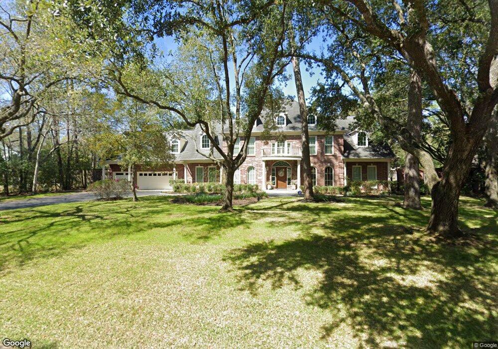
1 Patrick Ct Houston, TX 77024
Estimated Value: $2,357,000 - $2,807,000
About This Home
This home is located at 1 Patrick Ct, Houston, TX 77024 and is currently estimated at $2,508,662, approximately $487 per square foot. 1 Patrick Ct is a home located in Harris County with nearby schools including Bunker Hill Elementary School, Memorial Middle, and Memorial High School.
Ownership History
We collect this data history from publicly available records. To have your information removed, we recommend requesting removal directly through your county’s website.
Purchase Details
Home Financials for this Owner
Home Financials are based on the most recent Mortgage that was taken out on this home.Purchase Details
Home Financials for this Owner
Home Financials are based on the most recent Mortgage that was taken out on this home.Purchase Details
Home Financials for this Owner
Home Financials are based on the most recent Mortgage that was taken out on this home.Purchase Details
Home Financials for this Owner
Home Financials are based on the most recent Mortgage that was taken out on this home.Purchase Details
Home Values in the Area
Average Home Value in this Area
Purchase History
We collect this data history from publicly available records. To have your information removed, we recommend requesting removal directly through your county’s website.
| Date | Buyer | Sale Price | Title Company |
|---|---|---|---|
| -- | None Available | ||
| -- | First American Title | ||
| -- | Texas American Title Company | ||
| -- | First American Title | ||
| -- | -- |
Mortgage History
We collect this data history from publicly available records. To have your information removed, we recommend requesting removal directly through your county’s website.
| Date | Status | Borrower | Loan Amount |
|---|---|---|---|
| Open | $1,175,000 | ||
| Previous Owner | $219,550 | ||
| Previous Owner | $999,500 | ||
| Previous Owner | $700,000 | ||
| Previous Owner | $525,000 | ||
| Closed | $0 |
Tax History
We collect this data history from publicly available records. To have your information removed, we recommend requesting removal directly through your county’s website.
| Year | Tax Paid | Tax Assessment Tax Assessment Total Assessment is a certain percentage of the fair market value that is determined by local assessors to be the total taxable value of land and additions on the property. | Land | Improvement |
|---|---|---|---|---|
| 2025 | $25,902 | $2,085,896 | $1,080,648 | $1,005,248 |
| 2024 | $26,853 | $1,725,000 | $1,044,626 | $680,374 |
| 2023 | $26,853 | $1,910,720 | $990,594 | $920,126 |
| 2022 | $35,042 | $1,685,317 | $990,594 | $694,723 |
| 2021 | $35,495 | $1,639,000 | $936,562 | $702,438 |
| 2020 | $36,858 | $1,664,250 | $936,562 | $727,688 |
| 2019 | $38,617 | $1,674,139 | $936,562 | $737,577 |
| 2018 | $8,384 | $1,650,000 | $936,562 | $713,438 |
| 2017 | $40,431 | $1,752,800 | $936,562 | $816,238 |
| 2016 | $41,255 | $1,788,500 | $936,562 | $851,938 |
| 2015 | $30,783 | $1,822,600 | $936,562 | $886,038 |
| 2014 | $30,783 | $1,625,000 | $810,486 | $814,514 |
Map
- 12115 Beauregard Dr
- 11909 Knippwood Ln
- 601 Strey Ln
- 11840 Stuckey Ln
- 345 Knipp Rd
- 12127 Overcup Dr
- 12222 Old Oaks Dr
- 12302 Beauregard Dr
- 26 Valley Forge Dr
- 634 Knipp Rd
- 318 Knipp Rd
- 306 Gessner Rd
- 337 Folwell Ln
- 12334 Beauregard Dr
- 8 Greyton Ln
- 727 Bunker Hill Rd Unit 103
- 215 Tamerlaine Dr
- 735 Timber Hill Dr
- 1 Gage Ct
- 12122 Kimberley Ln
- 2 Rip Van Winkle Ln
- 3 Patrick Ct
- 2 Patrick Ct
- 4 Patrick Ct
- 12010 Tall Oaks St
- 4 Rip Van Winkle Ln
- 5 Patrick Ct
- 1 Rip Van Winkle Ln
- 11934 Surrey Ln
- 451 Strey Ln
- 431 Strey Ln
- 11930 Surrey Ln
- 6 Patrick Ct
- 3 Rip Van Winkle Ln
- 12010 Surrey Ln
- 1 Duchess Ct
- 11926 Surrey Ln
- 12014 Tall Oaks St
- 6 Rip Van Winkle Ln
- 7 Patrick Ct
Ask me questions while you tour the home.