G
Seller's Agent in 2026
Geoffrey Crain
RE/MAX
(207) 400-6758
1 in this area
13 Total Sales
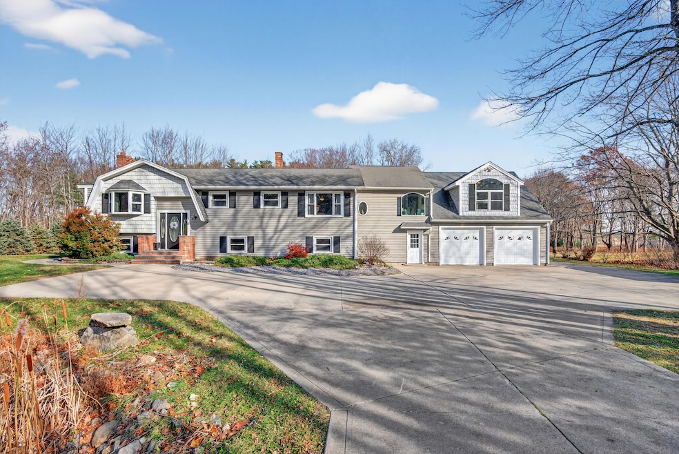


Tucked along Willow Ridge Way, this peaceful coastal retreat offers over 3,200± sq ft of flexible living space, located just a half-mile walk to Hills Beach. Set in a quiet neighborhood near the University of New England, 1 Willow Ridge Way blends space, comfort, and indoor-outdoor living in a desirable coastal setting. Sunlight fills the dining room through oversized windows, naturally drawing gatherings toward the heart of the home and out to the expansive deck beyond. Multiple living areas provide flexibility for entertaining, remote work, guests, or multi-generational living. The expansive primary suite offers a private retreat with a large bath, walk-in closet, and direct deck access. Outdoor living is a highlight, featuring morning sun and afternoon shade on the deck, overlooking a grassy backyard with fire pit area and wooded backdrop. Seasonal glimpses toward Biddeford Pool and visits from local wildlife enhance the tranquil setting. Interior features include hardwood floors throughout the first floor, stainless steel appliances, four heat pumps installed in 2022, a newer furnace, and a roof with ample remaining life. An oversized two-car garage, workshop/storage room, shed, and additional utility space provide exceptional storage for a coastal property. Enjoy an easy, mostly flat walk to Hills Beach, nearby routes along Old Pool Road for walking and running, summer paddleboarding, and sunset beach walks. The University of New England is approximately a quarter mile away via wooded road access, with Biddeford's downtown, shops, and dining just minutes away. Well maintained and offering an opportunity to personalize, 1 Willow Ridge Way presents a versatile option for a primary residence, seasonal home, or investment opportunity in a sought-after coastal location.
We collect this data history from publicly available records. To have your information removed, we recommend requesting removal directly through your county’s website.
We collect this data history from publicly available records. To have your information removed, we recommend requesting removal directly through your county’s website.
| Date | Type | Sale Price | Title Company |
|---|---|---|---|
| Warranty Deed | $550,000 | -- | |
| Quit Claim Deed | -- | -- | |
| Quit Claim Deed | -- | -- |
We collect this data history from publicly available records. To have your information removed, we recommend requesting removal directly through your county’s website.
| Date | Status | Loan Amount | Loan Type |
|---|---|---|---|
| Previous Owner | $228,200 | Purchase Money Mortgage |
We collect this data history from publicly available records. To have your information removed, we recommend requesting removal directly through your county’s website.
| Date | Event | Price | List to Sale | Price per Sq Ft |
|---|---|---|---|---|
| 03/09/2026 03/09/26 | Sold | $550,000 | -15.3% | $171 / Sq Ft |
| 02/17/2026 02/17/26 | Pending | -- | -- | -- |
| 02/10/2026 02/10/26 | Price Changed | $649,000 | -7.3% | $202 / Sq Ft |
| 01/21/2026 01/21/26 | Price Changed | $699,900 | -5.4% | $218 / Sq Ft |
| 12/12/2025 12/12/25 | Price Changed | $739,900 | -3.9% | $230 / Sq Ft |
| 11/21/2025 11/21/25 | For Sale | $769,900 | -- | $240 / Sq Ft |
We collect this data history from publicly available records. To have your information removed, we recommend requesting removal directly through your county’s website.
| Year | Tax Paid | Tax Assessment Tax Assessment Total Assessment is a certain percentage of the fair market value that is determined by local assessors to be the total taxable value of land and additions on the property. | Land | Improvement |
|---|---|---|---|---|
| 2025 | $8,398 | $562,100 | $182,500 | $379,600 |
| 2024 | $7,889 | $554,800 | $182,500 | $372,300 |
| 2023 | $7,237 | $551,600 | $179,300 | $372,300 |
| 2022 | $7,183 | $437,700 | $104,300 | $333,400 |
| 2021 | $6,329 | $372,200 | $88,300 | $283,900 |
| 2020 | $6,835 | $340,900 | $80,200 | $260,700 |
| 2019 | $2,872 | $340,900 | $80,200 | $260,700 |
| 2018 | $2,740 | $340,900 | $80,200 | $260,700 |
| 2017 | $2,636 | $320,500 | $80,200 | $240,300 |
| 2016 | $2,529 | $320,500 | $80,200 | $240,300 |
| 2015 | $6,045 | $320,500 | $80,200 | $240,300 |
| 2014 | $5,896 | $320,500 | $80,200 | $240,300 |
| 2013 | -- | $340,500 | $89,200 | $251,300 |
G
Seller's Agent in 2026
Geoffrey Crain
RE/MAX
(207) 400-6758
1 in this area
13 Total Sales

Seller Co-Listing Agent in 2026
Derrick Buckspan
RE/MAX
(207) 939-0207
1 in this area
188 Total Sales
S
Buyer's Agent in 2026
Steve Foran
First Maine Real Estate
(207) 282-7588
12 in this area
51 Total Sales
Source: Maine Listings
MLS Number: 1644124
APN: BIDD-000009-000000-000002-000003
Disclaimer: Certain information contained herein is derived from information provided by parties other than Homes.com. All information provided is deemed reliable, but is not guaranteed to be accurate and should be independently verified.
![]() Listing data is derived in whole or in part from Maine Real Estate Information System, Inc. (d/b/a Maine Listings) and is for consumers' personal, noncommercial use only. Dimensions are approximate and not guaranteed. All data should be independently verified.
Listing data is derived in whole or in part from Maine Real Estate Information System, Inc. (d/b/a Maine Listings) and is for consumers' personal, noncommercial use only. Dimensions are approximate and not guaranteed. All data should be independently verified.
© 2026 Maine Real Estate Information System, Inc. All Rights Reserved. Equal Housing Opportunity.
Homes.com, LLC, 17600 Laguna Canyon Rd Irvine, CA 92618 (888)-952-6393
![]()
Ask me questions while you tour the home.