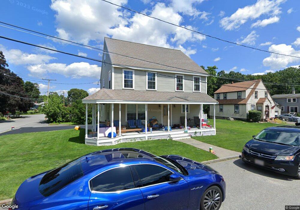
1 Winstead Ave Woburn, MA 01801
Mishawum NeighborhoodEstimated Value: $644,000 - $739,000
About This Home
This home is located at 1 Winstead Ave, Woburn, MA 01801 and is currently estimated at $694,595, approximately $890 per square foot. 1 Winstead Ave is a home located in Middlesex County with nearby schools including Malcolm White Elementary School, John F. Kennedy Middle School, and Woburn High School.
Ownership History
We collect this data history from publicly available records. To have your information removed, we recommend requesting removal directly through your county’s website.
Purchase Details
Purchase Details
Home Financials for this Owner
Home Financials are based on the most recent Mortgage that was taken out on this home.Purchase Details
Home Values in the Area
Average Home Value in this Area
Purchase History
We collect this data history from publicly available records. To have your information removed, we recommend requesting removal directly through your county’s website.
| Date | Buyer | Sale Price | Title Company |
|---|---|---|---|
| -- | -- | ||
| -- | -- | ||
| $250,000 | -- | ||
| $250,000 | -- | ||
| -- | -- | ||
| -- | -- |
Mortgage History
We collect this data history from publicly available records. To have your information removed, we recommend requesting removal directly through your county’s website.
| Date | Status | Borrower | Loan Amount |
|---|---|---|---|
| Previous Owner | $200,000 |
Tax History
We collect this data history from publicly available records. To have your information removed, we recommend requesting removal directly through your county’s website.
| Year | Tax Paid | Tax Assessment Tax Assessment Total Assessment is a certain percentage of the fair market value that is determined by local assessors to be the total taxable value of land and additions on the property. | Land | Improvement |
|---|---|---|---|---|
| 2025 | $5,224 | $611,700 | $283,000 | $328,700 |
| 2024 | $4,701 | $583,300 | $269,600 | $313,700 |
| 2023 | $4,600 | $528,700 | $245,100 | $283,600 |
| 2022 | $4,486 | $480,300 | $213,100 | $267,200 |
| 2021 | $4,309 | $461,800 | $202,900 | $258,900 |
| 2020 | $4,164 | $446,800 | $202,900 | $243,900 |
| 2019 | $4,089 | $430,400 | $193,300 | $237,100 |
| 2018 | $3,888 | $393,100 | $177,300 | $215,800 |
| 2017 | $3,625 | $364,700 | $168,900 | $195,800 |
| 2016 | $3,468 | $345,100 | $157,900 | $187,200 |
| 2015 | $3,346 | $329,000 | $147,500 | $181,500 |
| 2014 | $3,271 | $313,300 | $147,500 | $165,800 |
Map
- 37 Maple Ave
- 74 Beach St Unit 6-8
- 6 Fairview Terrace
- 0 Fryeburg Rd
- 42 Wood St
- 18 Sherman Place
- 106 Mishawum Rd
- 50 Mishawum Rd
- 159 Mishawum Rd
- 17 Cronin Way
- 6 Packard St
- 49 Eaton Ave
- 15 Cronin Way
- 8 Woods Hill Cir
- 16 Felton St
- 6 Cooley Dr Unit 6
- 305 Salem St Unit 312
- 605 Main St
- 555 Main St Unit 6
- 7 Dewey Ave
Ask me questions while you tour the home.