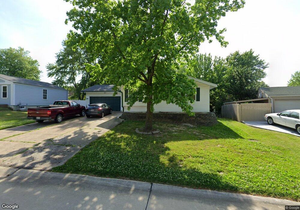
10 Antelope Dr Saint Peters, MO 63376
Estimated Value: $252,000 - $273,000
3
Beds
2
Baths
1,094
Sq Ft
$239/Sq Ft
Est. Value
About This Home
This home is located at 10 Antelope Dr, Saint Peters, MO 63376 and is currently estimated at $261,370, approximately $238 per square foot. 10 Antelope Dr is a home located in St. Charles County with nearby schools including Progress South Elementary School, Fort Zumwalt South Middle School, and Fort Zumwalt South High School.
Ownership History
Date
Name
Owned For
Owner Type
Purchase Details
Closed on
May 22, 2018
Sold by
Luedloff Thomas E
Bought by
Luedloff Thomas W
Current Estimated Value
Home Financials for this Owner
Home Financials are based on the most recent Mortgage that was taken out on this home.
Original Mortgage
$120,000
Outstanding Balance
$103,324
Interest Rate
4.4%
Mortgage Type
New Conventional
Estimated Equity
$158,046
Purchase Details
Closed on
Dec 17, 1999
Sold by
York Ronald J and York Laura D
Bought by
Luedloff Thomas W
Create a Home Valuation Report for This Property
The Home Valuation Report is an in-depth analysis detailing your home's value as well as a comparison with similar homes in the area
Home Values in the Area
Average Home Value in this Area
Purchase History
| Date | Buyer | Sale Price | Title Company |
|---|---|---|---|
| Luedloff Thomas W | -- | Freedom Title | |
| Luedloff Thomas W | $48,000 | -- |
Source: Public Records
Mortgage History
| Date | Status | Borrower | Loan Amount |
|---|---|---|---|
| Open | Luedloff Thomas W | $120,000 |
Source: Public Records
Tax History
| Year | Tax Paid | Tax Assessment Tax Assessment Total Assessment is a certain percentage of the fair market value that is determined by local assessors to be the total taxable value of land and additions on the property. | Land | Improvement |
|---|---|---|---|---|
| 2025 | $2,616 | $46,581 | -- | -- |
| 2023 | $2,615 | $42,855 | $0 | $0 |
| 2022 | $2,121 | $32,375 | $0 | $0 |
| 2021 | $2,120 | $32,375 | $0 | $0 |
| 2020 | $2,017 | $29,781 | $0 | $0 |
| 2019 | $2,010 | $29,781 | $0 | $0 |
| 2018 | $1,822 | $25,827 | $0 | $0 |
| 2017 | $1,812 | $25,827 | $0 | $0 |
| 2016 | $1,652 | $23,503 | $0 | $0 |
| 2015 | $1,531 | $23,503 | $0 | $0 |
| 2014 | $1,549 | $23,221 | $0 | $0 |
Source: Public Records
Map
Nearby Homes
- 5 Covered Wagon Trail Ct
- 14 Canter Ct
- 15 Canter Ct
- 23 Oak Knoll Dr
- 42 Oak Knoll Dr
- 32 Queensboro Dr
- 474 Calumet Ranch Trail
- 83 Foxgate Ct
- 179 Abington Dr
- 7 Shetland Pony Ct
- 118 Arabian Path
- 1 the Madison 2 Car at Strawberry Farms
- 2073 Williamstown Dr
- 1 the Hamilton II 2 Car at Strawberry Farms
- 1 the Washington 2 Car at Strawberry Farms
- 1 the Adams 2 Car at Strawberry Farms
- 1 the Franklin 2 Car at Strawbery Farms
- 366 Strawberry Grove Dr
- 369 Strawberry Grove Dr
- 190 Hutchings Farm Dr N
Your Personal Tour Guide
Ask me questions while you tour the home.