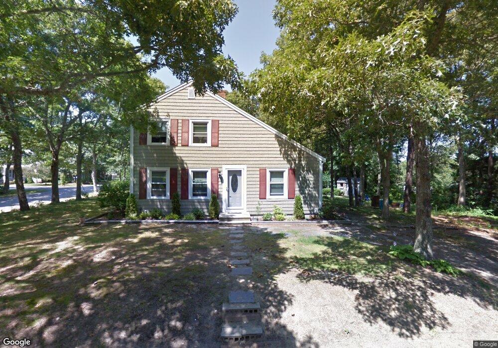
10 Captain Prestons Rd Dennis, MA 02638
Dennis Village NeighborhoodEstimated Value: $547,979 - $698,000
3
Beds
2
Baths
1,344
Sq Ft
$459/Sq Ft
Est. Value
About This Home
This home is located at 10 Captain Prestons Rd, Dennis, MA 02638 and is currently estimated at $616,745, approximately $458 per square foot. 10 Captain Prestons Rd is a home located in Barnstable County with nearby schools including Dennis-Yarmouth Regional High School and St. Pius X. School.
Ownership History
Date
Name
Owned For
Owner Type
Purchase Details
Closed on
Oct 31, 1989
Sold by
Franchino James H
Bought by
Mailloux Catherine
Current Estimated Value
Home Financials for this Owner
Home Financials are based on the most recent Mortgage that was taken out on this home.
Original Mortgage
$118,700
Interest Rate
9.94%
Mortgage Type
Purchase Money Mortgage
Create a Home Valuation Report for This Property
The Home Valuation Report is an in-depth analysis detailing your home's value as well as a comparison with similar homes in the area
Home Values in the Area
Average Home Value in this Area
Purchase History
| Date | Buyer | Sale Price | Title Company |
|---|---|---|---|
| Mailloux Catherine | $125,000 | -- |
Source: Public Records
Mortgage History
| Date | Status | Borrower | Loan Amount |
|---|---|---|---|
| Open | Mailloux Catherine | $213,766 | |
| Closed | Mailloux Catherine | $118,700 |
Source: Public Records
Tax History
| Year | Tax Paid | Tax Assessment Tax Assessment Total Assessment is a certain percentage of the fair market value that is determined by local assessors to be the total taxable value of land and additions on the property. | Land | Improvement |
|---|---|---|---|---|
| 2025 | $1,985 | $458,500 | $176,400 | $282,100 |
| 2024 | $2,028 | $462,000 | $177,700 | $284,300 |
| 2023 | $1,962 | $420,200 | $161,600 | $258,600 |
| 2022 | $1,818 | $324,600 | $132,300 | $192,300 |
| 2021 | $1,769 | $293,300 | $129,700 | $163,600 |
| 2020 | $1,687 | $276,500 | $129,700 | $146,800 |
| 2019 | $1,771 | $287,100 | $139,900 | $147,200 |
| 2018 | $1,581 | $249,300 | $121,100 | $128,200 |
| 2017 | $1,533 | $249,300 | $121,100 | $128,200 |
| 2016 | $1,687 | $258,300 | $151,300 | $107,000 |
| 2015 | $1,653 | $258,300 | $151,300 | $107,000 |
| 2014 | $1,495 | $235,500 | $121,100 | $114,400 |
Source: Public Records
Map
Nearby Homes
- 14 S Yarmouth Rd
- 59 Main St Unit 7-3
- 59 Main St Unit 19-2
- 59 Route 6a Unit 9-2
- 59 Route 6a Unit 7-3
- 59 Massachusetts 6a Unit 19-2
- 568 Route 6a
- 39 Whittier Dr
- 1014 Route 6a
- 26 S West Dr
- 20 Bray Farm Rd S
- 268 Main St
- 111 Merchant Ave
- 15 Musket Ln
- 150 Merchant Ave
- 17 Eileen St
- 10 Lake Dr
- 16 Hazelwood Rd
- 150 Merchant Ave
- 154 Bayridge Dr
- 11 Capt Prestons Rd
- 20 Captain Prestons Rd
- 41 S Yarmouth Rd
- 23 Capt Prestons Rd
- 47 S Yarmouth Rd
- 23 Captain Prestons Rd
- 11 Captain Prestons Rd
- 17 Captain Prestons Rd
- 3 Captain Prestons Rd
- 26 Captain Prestons Rd
- 46 S Yarmouth Rd
- 53 S Yarmouth Rd
- 42 S Yarmouth Rd
- 29 Captain Prestons Rd
- 40 S Yarmouth Rd
- 37 S Yarmouth Rd
- 50 S Yarmouth Rd
- 29 S Yarmouth Rd
- 52 S Yarmouth Rd
- 1 Flax St
Your Personal Tour Guide
Ask me questions while you tour the home.