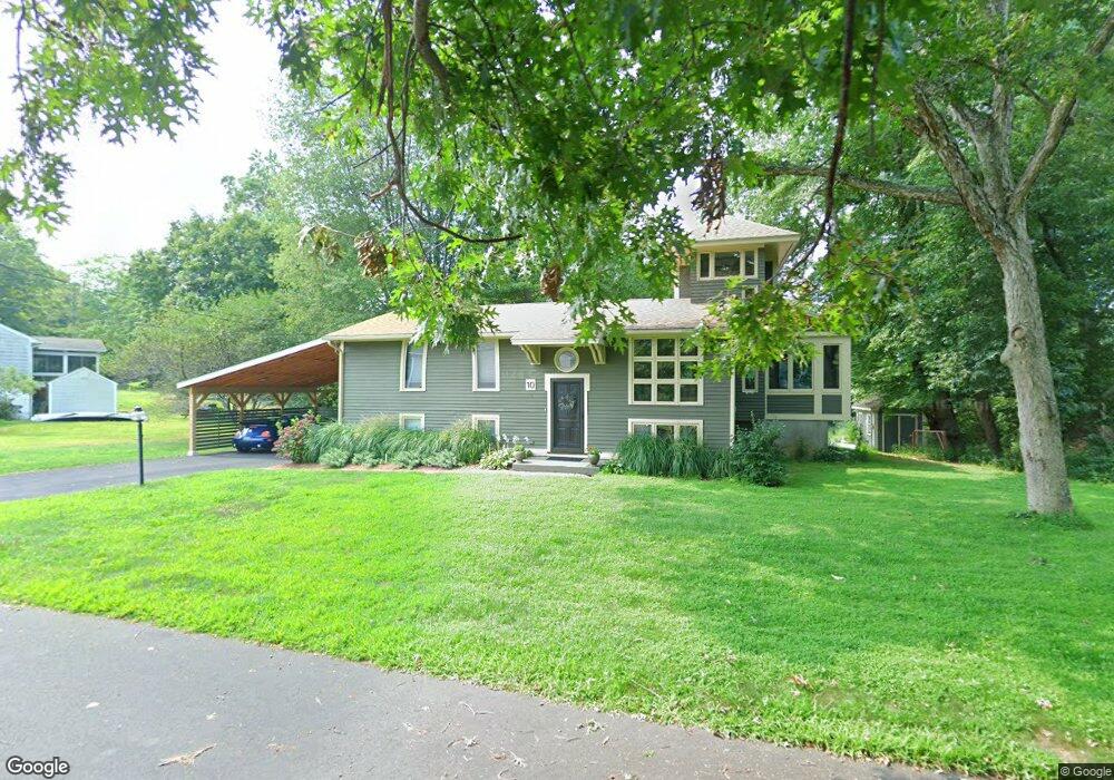
10 Fieldbrook Ave Clinton, CT 06413
Estimated Value: $533,000 - $684,000
3
Beds
2
Baths
1,799
Sq Ft
$328/Sq Ft
Est. Value
About This Home
This home is located at 10 Fieldbrook Ave, Clinton, CT 06413 and is currently estimated at $590,886, approximately $328 per square foot. 10 Fieldbrook Ave is a home located in Middlesex County with nearby schools including Lewin G. Joel Jr. School and The Morgan School.
Ownership History
Date
Name
Owned For
Owner Type
Purchase Details
Closed on
Jan 31, 2022
Sold by
Polk Jamie
Bought by
Vanness Polk T
Current Estimated Value
Purchase Details
Closed on
May 27, 2004
Sold by
Lasky William A
Bought by
Polk Jamie M
Home Financials for this Owner
Home Financials are based on the most recent Mortgage that was taken out on this home.
Original Mortgage
$279,900
Interest Rate
5.88%
Purchase Details
Closed on
Mar 21, 1988
Sold by
Mitchell Gary D
Bought by
Lasky William A
Purchase Details
Closed on
Jan 16, 1987
Sold by
Robicheau Allen P
Bought by
Mitchell Gary D
Create a Home Valuation Report for This Property
The Home Valuation Report is an in-depth analysis detailing your home's value as well as a comparison with similar homes in the area
Home Values in the Area
Average Home Value in this Area
Purchase History
We collect this data history from publicly available records. To have your information removed, we recommend requesting removal directly through your county’s website.
| Date | Buyer | Sale Price | Title Company |
|---|---|---|---|
| Vanness Polk T | -- | None Available | |
| Vanness Polk T | -- | None Available | |
| Polk Jamie M | $379,900 | -- | |
| Polk Jamie M | $379,900 | -- | |
| Lasky William A | $138,500 | -- | |
| Mitchell Gary D | $140,000 | -- |
Source: Public Records
Mortgage History
We collect this data history from publicly available records. To have your information removed, we recommend requesting removal directly through your county’s website.
| Date | Status | Borrower | Loan Amount |
|---|---|---|---|
| Previous Owner | Mitchell Gary D | $50,000 | |
| Previous Owner | Mitchell Gary D | $279,900 |
Source: Public Records
Tax History
| Year | Tax Paid | Tax Assessment Tax Assessment Total Assessment is a certain percentage of the fair market value that is determined by local assessors to be the total taxable value of land and additions on the property. | Land | Improvement |
|---|---|---|---|---|
| 2025 | $7,475 | $240,055 | $51,255 | $188,800 |
| 2024 | $7,264 | $240,055 | $51,255 | $188,800 |
| 2023 | $7,161 | $240,055 | $51,255 | $188,800 |
| 2022 | $7,161 | $240,055 | $51,255 | $188,800 |
| 2021 | $6,616 | $221,800 | $51,200 | $170,600 |
| 2020 | $6,931 | $221,800 | $51,200 | $170,600 |
| 2019 | $6,931 | $221,800 | $51,200 | $170,600 |
| 2018 | $6,774 | $221,800 | $51,200 | $170,600 |
| 2017 | $6,634 | $221,800 | $51,200 | $170,600 |
| 2016 | $6,020 | $221,800 | $51,200 | $170,600 |
| 2015 | $5,624 | $210,100 | $54,500 | $155,600 |
| 2014 | $5,519 | $210,100 | $54,500 | $155,600 |
Source: Public Records
Map
Nearby Homes
- 166 Glenwood Rd
- 15 Brickyard Rd
- 28 Rocky Ledge Dr
- 0 Fairy Dell Rd
- 50 Jefferson Cir
- 51 Ironworks Rd
- 49 Kelseytown Rd
- 48A Ironworks Rd
- 145 Liberty St
- 43 Evergreen Park
- 9 Ben Merrill Rd
- 14 Hill View Ln
- 4 Laurel Ln
- 15 Partridge Ln
- 244 Cow Hill Rd
- 64 W Main St
- 0 Cow Hill Rd
- 51 Nod Place
- 24 Tower Hill Rd
- 102 Lantern Ct
- 8 Fieldbrook Ave
- 12 Fieldbrook Ave
- 4 Fieldbrook Ave
- 14 Fieldbrook Ave
- 19 Fieldbrook Ave
- 13 Fieldbrook Ave
- 17 Fieldbrook Ave
- 15 Fieldbrook Ave
- 150 Glenwood Rd
- 152 Glenwood Rd
- 144 Glenwood Rd
- 168 Glenwood Rd
- 170 Glenwood Rd
- 164 Glenwood Rd
- 7 Fieldbrook Ave
- 9 Fieldbrook Ave
- 172 Glenwood Rd
- 5 Fieldbrook Ave
- 7 Lochbourne Dr
- 0 Glenwood Rd Unit M9143405
Your Personal Tour Guide
Ask me questions while you tour the home.